MyTopo
Kinzel Springs Tennessee US Topo Map
Couldn't load pickup availability
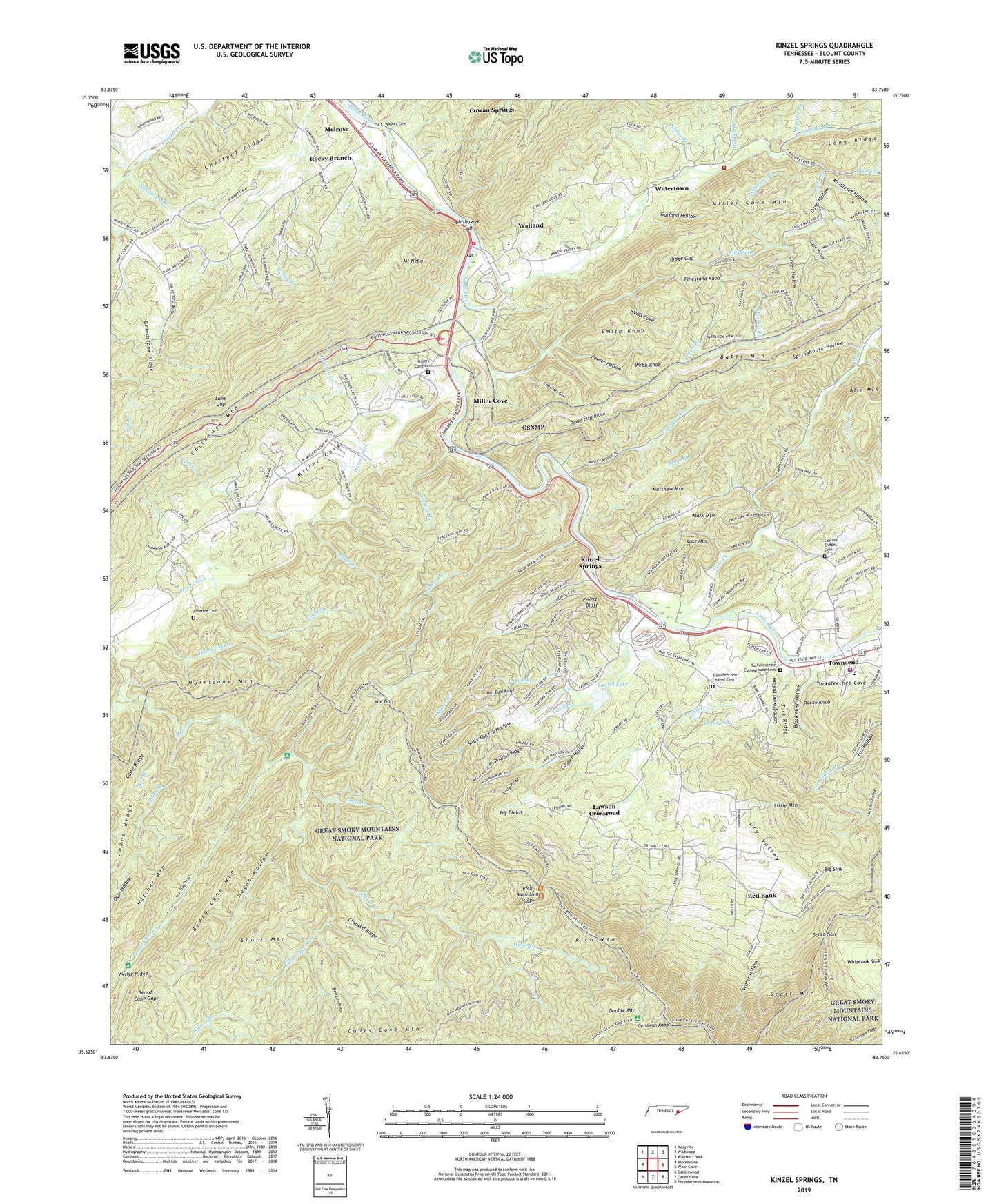
2022 topographic map quadrangle Kinzel Springs in the state of Tennessee. Scale: 1:24000. Based on the newly updated USGS 7.5' US Topo map series, this map is in the following counties: Blount. The map contains contour data, water features, and other items you are used to seeing on USGS maps, but also has updated roads and other features. This is the next generation of topographic maps. Printed on high-quality waterproof paper with UV fade-resistant inks.
Quads adjacent to this one:
West: Blockhouse
Northwest: Maryville
North: Wildwood
Northeast: Walden Creek
East: Wear Cove
Southeast: Thunderhead Mountain
South: Cades Cove
Southwest: Calderwood
This map covers the same area as the classic USGS quad with code o35083f7.
Contains the following named places: Ace Gap, Ace Gap Campsite, Alie Mountain, Amerine Cemetery, Amrines Forge, Bark Camp Run, Beard Cane Campsite, Beard Cane Creek, Beard Cane Gap, Beard Cane Mountain, Bearpen Ridge, Big Sink, Black Mash Hollow, Blair Branch, Blount County Fire Protection District Station 5, Briar Branch, Cagle Hollow, Campground Church, Campground Hollow, Cane Creek, Cane Ridge, Capshaw Branch, Carr Creek, Caylor Chapel, Caylor School, Caylors Chapel Cemetery, Cerulean Knob, Chestnut Cove, Chestnut Ridge, Chilhowee Gap, City of Townsend, Cold Spring Gap, College Hill School, Commissioner District 8, Cooper Hollow, Coughron School, Cowan Springs, Crooked Ridge, Dan Branch, Davis Branch, Double Branch, Double Mountain, Double Mountain Campsite, Dry Valley, Dunn Hollow, Dunn Spring, East Mountain View Church, Emert Bluff, Flat Creek, Fowler Hollow, Fry Fields, Garland Hollow, Green Hollow, Grindstone Ridge, Hatcher Creek, Hatcher Mountain, Henrys Fort, Hesse Creek, Hesse Creek Campsite, Hodge Branch, Hogan Hollow, Hurricane Branch, Hurricane Mountain, Huskey Branch, Johns Branch, Kelly Gap Campsite, Kelly Ridge, Kinzel Branch, Kinzel Springs, Lane Gap, Laurel Lake, Laurel Lake Dam, Laurel Valley Golf Course, Laws School, Lawson Crossroad, Lick Branch, Little Mountain, Luke Mountain, Mark Mountain, Martins Mill, Matthew Mountain, Meadow Branch, Melrose, Middleset Hollow, Mill Dam Ridge, Miller Cove, Miller Cove Mountain, Millers Cove Baptist Church, Millers Cove Cemetery, Millers Cove Church, Mount Nebo, Pinestand Knob, Powell Ridge, Raven Cliff Ridge, Red Bank, Red Bank School, Reed Creek, Rich Mountain, Rich Mountain Gap, Ridge Gap, Rigsby Branch, Roaring Branch, Rocky Branch, Rocky Branch Church, Rocky Branch School, Rocky Knob, Scott Gap, Seaton, Shell Branch, Short Creek, Short Mountain, Slate Quarry Hollow, Smith Branch, Smith Knob, Spicewood Branch, Springhouse Hollow, Stillhouse Branch, Stony Ridge, Sunshine, Tennessee Department of Agriculture Division of Forestry Blount, Tipton Branch, Townsend, Townsend Area Volunteer Fire Department Station 1, Townsend Area Volunteer Fire Department Station 2, Townsend Division, Townsend High School, Townsend Police Department, Townsend School, Trunk Branch, Tuckaleechee, Tuckaleechee Campground Cemetery, Tuckaleechee Chapel, Tuckaleechee Chapel Cemetery, Tuckaleechee Cove, Turkey Pen Ridge Campsite, Walker Cemetery, Walker Chapel, Walland, Walland Census Designated Place, Walland Elementary School, Walland High School, Walland Middle School, Walland Post Office, Water Hollow, Watertown, Webb Cove, Webb Knob, West Millers Cove, Wilburn Branch, Wolf Creek, Zack Ridge, ZIP Code: 37886