MyTopo
Cades Cove Tennessee US Topo Map
Couldn't load pickup availability
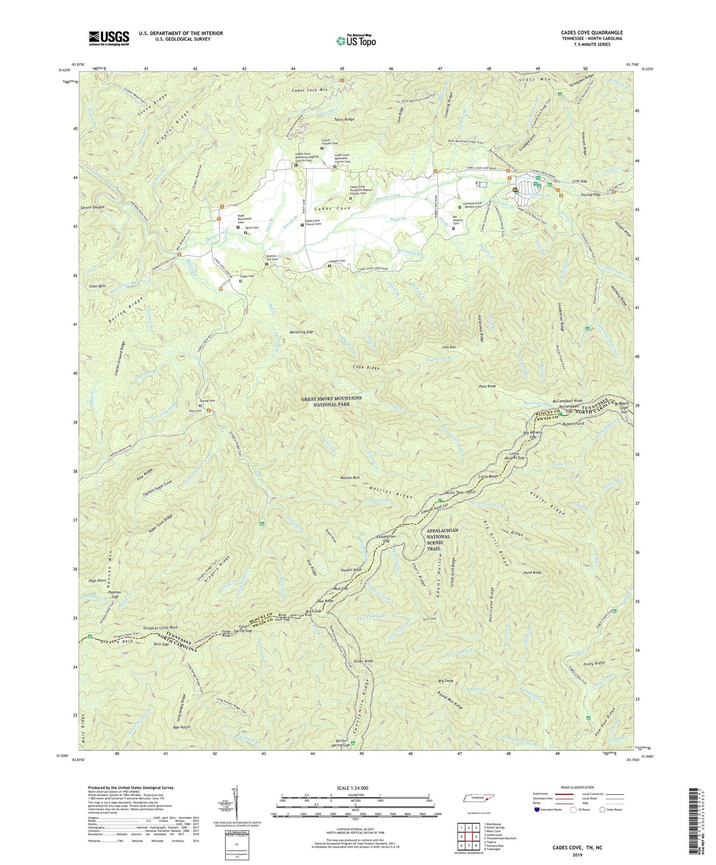
2022 topographic map quadrangle Cades Cove in the states of Tennessee, North Carolina. Scale: 1:24000. Based on the newly updated USGS 7.5' US Topo map series, this map is in the following counties: Blount, Swain. The map contains contour data, water features, and other items you are used to seeing on USGS maps, but also has updated roads and other features. This is the next generation of topographic maps. Printed on high-quality waterproof paper with UV fade-resistant inks.
Quads adjacent to this one:
West: Calderwood
Northwest: Blockhouse
North: Kinzel Springs
Northeast: Wear Cove
East: Thunderhead Mountain
Southeast: Tuskeegee
South: Fontana Dam
Southwest: Tapoco
This map covers the same area as the classic USGS quad with code o35083e7.
Contains the following named places: Abrams Falls Trail, Adams Hollow, Anthony Creek, Anthony Creek Horse Camp, Anthony Creek Trail, Arbutus Branch, Arbutus Ridge, Asgini Branch, Asgini Ridge, Becky Cable House, Big Abrams Gap, Big Grill Ridge, Big Swag, Big Tommy Branch, Birch Spring Gap, Birch Spring Shelter Spring, Boring Cemetery, Boring Ridge, Boulder Branch, Bower Creek, Brier Lick Branch, Brier Lick Gap, Brier Lick Knob, Browns Hill Cemetery, Buck Gap, Bunting Branch, Burnt Ridge Branch, Cable Cemetery, Cable School, Cades Branch, Cades Cove, Cades Cove Bloomery Forge, Cades Cove Campground, Cades Cove Group Campground, Cades Cove Methodist Church, Cades Cove Methodist Church Cemetery, Cades Cove Missionary Baptist Church, Cades Cove Missionary Baptist Church Cemetery, Cades Cove Mountain, Cades Cove Primitive Baptist Church, Cades Cove Primitive Baptist Church Cemetery, Cades Cove Visitor Center, Camp Ten Branch, Carter Shields Place, Carver - Feezell Cemetery, Cave Ridge, Chickadee Branch, Coalen Ground Branch, Coalen Ground Ridge, Cobb Butt, Cobb Ridge, Cold Spring Gap, Coon Butt, Cooper Branch, Cork Branch, Crib Gap, Crooked Arm, Crooked Arm Branch, Davis Cemetery, Devils Tater Patch, Devils Tater Patch Branch, Doe Knob, Doe Ridge, Ekaneetlee Branch, Ekaneetlee Gap, Elijah Oliver Place, Fanny Branch, Feezell Branch, Forge Creek, Forge Creek Campsite, Forge Knob, Forge Knob Branch, Graveyard Hill - Rowans Cemetery, Green Branch, Greer Knob, Gregory Bald, Gregory Ridge, Gregorys Little Bald, Grill Cove, Gunna Creek, Harrison Branch, Henry Whitehead Cabin, High Point, Horseshoe Ridge, Hurricane Branch, Hurricane Ridge, Hyatt Lane Church Cemetery, Ike Lequire Cemetery, Incline Gap, Indian Grave Gap, Ivy Branch, Ivy Ridge, John Oliver Cabin, John P Cable Mill Area, Lane Branch, Law Branch, Lawson Cemetery, Lawson Gant Lot, Lawson Gant Lot Branch, Leadbetter Ridge, Leading Ridge, Ledbetter Ridge Campsite, Left Prong Anthony Creek, Licklog Branch, Little Abrams Gap, Little Bald, Little Grill Ridge, Little Tommy Branch, Lonesome Branch, Long Hungry Ridge, Long Hungry Ridge Trail, Maple Branch, Maple Sugar Gap, Marthas Branch, Maynard Creek, McCampbell Gap, McCampbell Knob, McCaulley Branch, Mill Creek, Mollies Butt, Mollies Ridge, Mollies Ridge Shelter, Moore Springs Shelter, More Licker Branch, Mud Gap, Mud Gap Branch, Narrow Creek, Noah Burchfield Cemetery, Oliver Branch, Panther Branch, Panther Gap, Peter Cable Place, Pine Oak Trail, Pine Ridge, Piney Ridge, Pinkroot Ridge, Pole Knob, Pole Knob Branch, Pond Knob, Post Cemetery, Powell Knob, Powell Ridge, Proctor Sang Branch, Rich Gap, Rich Mountain Trail, Round Mountain Branch, Round Mountain Ridge, Rowans Creek, Russell Field, Russell Field Branch, Russell Field Shelter, Russell Field Trail, Rye Patch, Rye Patch Branch, Scott Mountain, Sea Branch, Sheep Pen Gap, Sheep Pen Gap Campsite, Shelter Branch, Short Ridge, Spruce Double, Stillhouse Branch, Stony Branch, Stony Gap, Sugar Cove Branch, Sugar Cove Ridge, Tater Branch, Tater Ridge, Thomas Cove Branch, Tipton Oliver Place, Tiptons Sugar Cove, Tiptons Sugar Cove Branch, Titmouse Branch, Tub-Mill Creek, Turkeypen Ridge, Twentymile Ridge, Victory Branch, Vista Trail, Whistling Branch, Whistling Gap, Wildcat Branch, ZIP Code: 37882