MyTopo
Thunderhead Mountain North Carolina US Topo Map
Couldn't load pickup availability
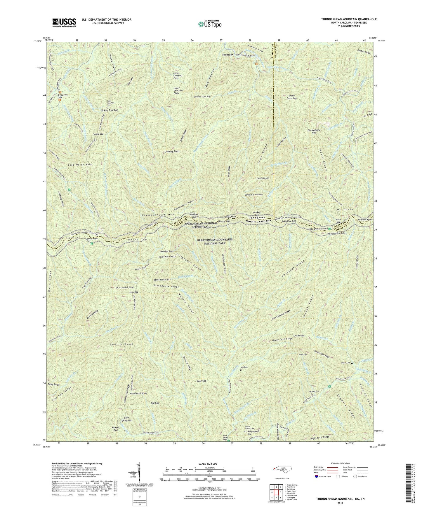
2022 topographic map quadrangle Thunderhead Mountain in the states of North Carolina, Tennessee. Scale: 1:24000. Based on the newly updated USGS 7.5' US Topo map series, this map is in the following counties: Swain, Blount, Sevier. The map contains contour data, water features, and other items you are used to seeing on USGS maps, but also has updated roads and other features. This is the next generation of topographic maps. Printed on high-quality waterproof paper with UV fade-resistant inks.
Quads adjacent to this one:
West: Cades Cove
Northwest: Kinzel Springs
North: Wear Cove
Northeast: Gatlinburg
East: Silers Bald
Southeast: Noland Creek
South: Tuskeegee
Southwest: Fontana Dam
Contains the following named places: Allnight Ridge, Anthony Creek Campsite, Anthony Ridge, Bee Cove Creek, Bee Gum Branch, Beechnut Gap, Big Chestnut Bald, Big Flats Branch, Big Hollow, Big Medicine Gap, Big Spring Cove, Blockhouse Mountain, Blockhouse Ridge, Bote Mountain, Bote Mountain Cemetery, Brier Knob, Brier Ridge, Brushy Branch, Calhoun Branch, Calhoun Campsite, Calhoun Cemetery, Cherry Knob, Chestnut Ridge, Chimney Rocks, Churn Hollow, Cold Spring Branch, Cold Water Knob, Cope Branch, Davis Ridge, De Armond Bald, De Armond Ridge, Deep Gap, Deerhobble Branch, Deerhobble Ridge, Deerkill Branch, Defeat Branch, Defeat Ridge, Derrick Knob Shelter, Desolation Branch, Devils Bench, Devils Bench Branch, Devils Courthouse, Devils Nest Creek, Devils Race Patch, Doghobble Branch, Double Trestle Branch, Edens Garden Creek, Flint Spring Gap, Forrester Ridge, Green Camp Gap, Greenbriar Branch, Hall Cemetery, Haw Gap, Hawk Ridge Branch, Hickory Tree Branch, Hickory Tree Gap, Hornet Tree Top, Horse Cove Ridge, Huggins Branch, Indian Flats Prong, Jenkins Trail Ridge, Killpecker Ridge, Laurel Cove Creek, Little Chestnut Bald, Little Chestnut Ridge, Little Fork, Little Huggins Branch, Locust Gap, Locust Ridge, Log Ridge Branch, Long Branch, Long Cove Creek, Lost Branch, Lower Chestnut Flats, Lynn Camp Prong, Marks Creek, McCampbell Gap, Meadow Gap, Mill Branch, Mineral Gap, Mineral Gap Branch, Mount Davis, Mount Squires, New World, Nuna Ridge, Nunda Branch, Old House Branch, Panther Creek, Panther Den Ridge, Paw Paw Creek, Paw Paw Ridge, Pickens Gap, Pinkroot Branch, Raven Den, Roaring Creek, Rock Camp Branch, Rocky Top, Saddleback Ridge, Sally Sam Branch, Sams Creek, Sams Gap, Sams Ridge, Sandy Gap, Sawbrier Branch, Sawbrier Ridge, Seng Patch Branch, Shut-in Creek, Spence Cabin Branch, Spence Field, Spence Field Shelter, Starkey Creek, Starkey Gap, Starkey Ridge, Stone Camp Branch, Sugar Cove Prong, Sugartree Gap, Tali Gap, Thunderhead Mountain, Thunderhead Prong, Tremont, Unorganized Territory of Forneys Creek, Upper Chestnut Flats, Walker Cemetery, Walkers Creek, White Walnut Branch, Wildcat Branch, Wilkinson Ridge, Wilson Family Cemetery, Woodchuck Branch, Woodward Knob, Woolly Ridge, Woolly Ridge Branch