MyTopo
Leesburg Tennessee US Topo Map
Couldn't load pickup availability
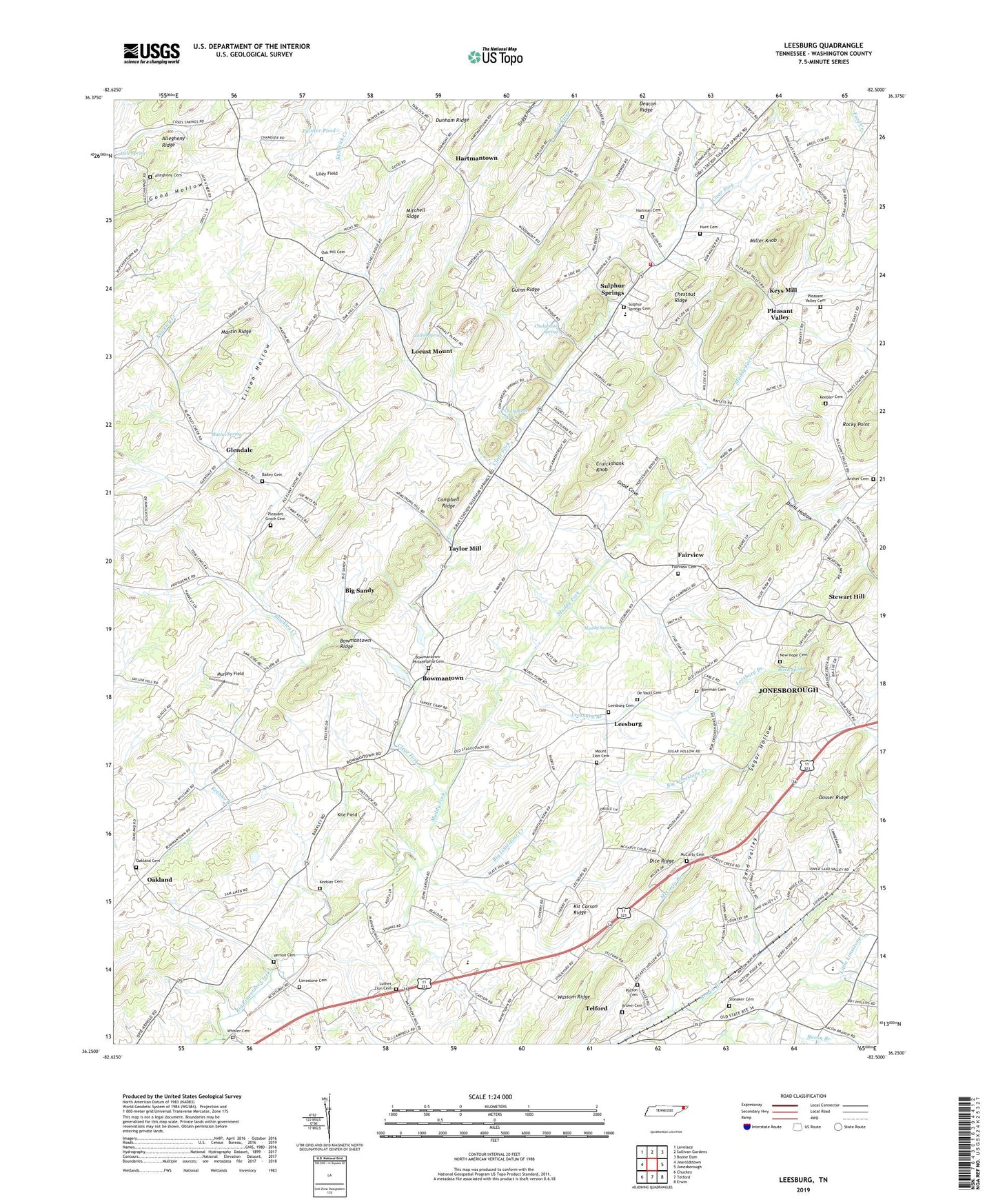
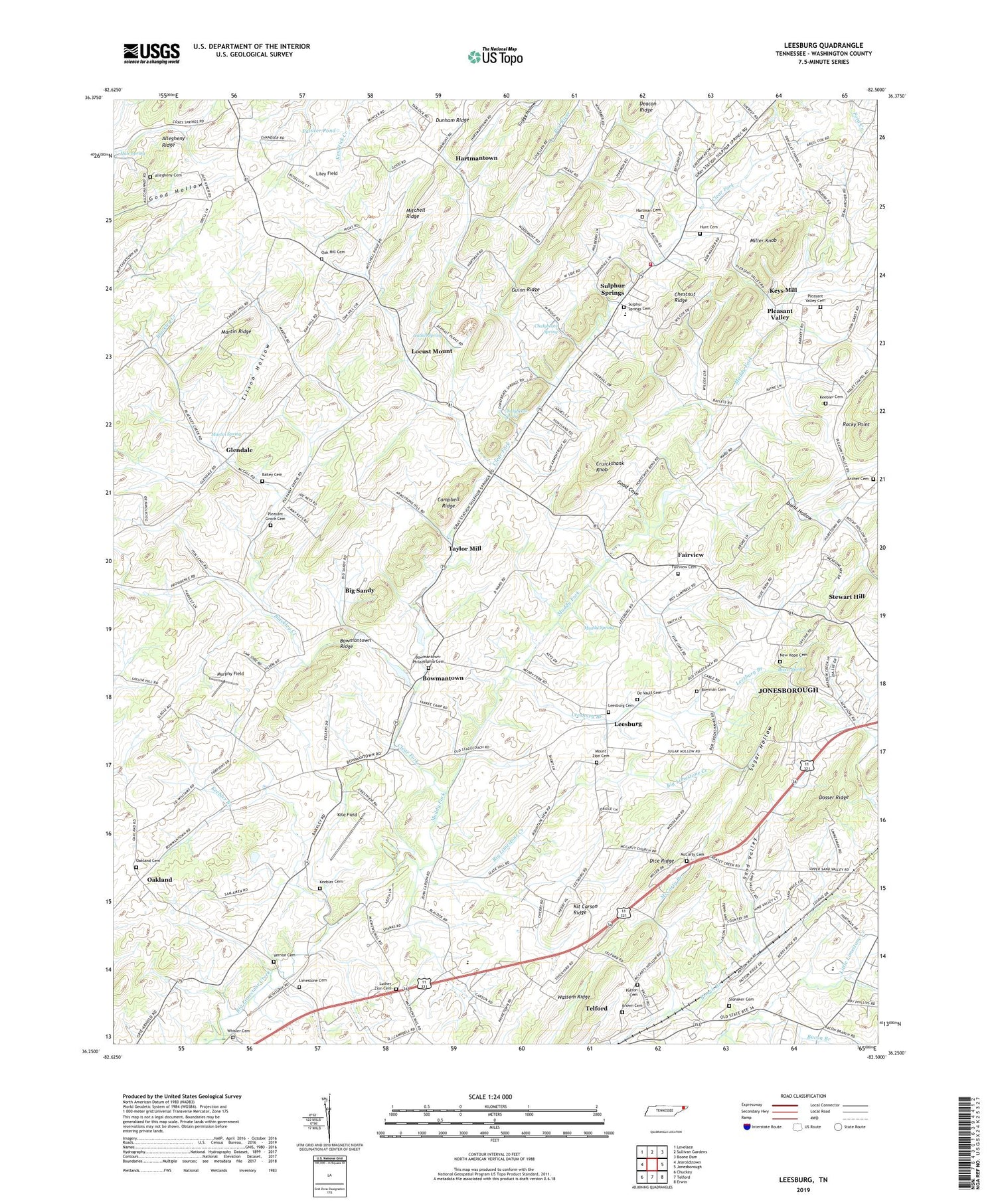
2019 topographic map quadrangle Leesburg in the state of Tennessee. Scale: 1:24000. Based on the newly updated USGS 7.5' US Topo map series, this map is in the following counties: Washington. The map contains contour data, water features, and other items you are used to seeing on USGS maps, but also has updated roads and other features. This is the next generation of topographic maps. Printed on high-quality waterproof paper with UV fade-resistant inks.
Quads adjacent to this one:
West: Jearoldstown
Northwest: Lovelace
North: Sullivan Gardens
Northeast: Boone Dam
East: Jonesborough
Southeast: Erwin
South: Telford
Southwest: Chuckey
Contains the following named places: Allegheny Cemetery, Allegheny Freewill Baptist Church, Allegheny School, Archer Cemetery, Bacon Branch, Bailey Cemetery, Bald Crossing, Bashors Mill, Beech Spring, Big Sandy, Blackley Creek, Bowman Cemetery, Bowmantown, Bowmantown Baptist Church, Bowmantown Ridge, Bowmantown School, Bowmantown-Philadelphia Cemetery, Brown Cemetery, Campbell Ridge, Campbell School, Chalybeate Spring, Chestnut Ridge, Christie, Clear Fork, Commissioner District 8, Cruickshank Knob, David Crockett High School, De Vault Cemetery, Deacon Store, Dice Ridge, Diehl Hollow, District 14, District 16, District 17, Dosser Ridge, Dunkard Church, Fairview, Fairview Cemetery, Fairview School, Ford Crossing, Gathel Spring, Glendale, Glendale School, Good Cove, Guinn Ridge, Hale Spring, Hartman Cemetery, Hartmantown, Hunt Cemetery, Johnson City Airport, Keebler Branch, Keebler Cemetery, Keebler Institute, Keys Mill, Kit Carson Ridge, Kite Field, Leesburg, Leesburg Branch, Leesburg Cemetery, Leesburg Presbyterian Church, Liley Field, Limestone Cemetery, Locust Mount, Luke, Luther Zion Cemetery, Martin Ridge, Martin Spring, Matuta, Mayflower, McCarty Branch, McCarty Cemetery, McCarty United Methodist Church, Miller Knob, Mitchell Ridge, Mount Zion Cemetery, Mount Zion Methodist Church, Mountain View School, Muddy Fork, Muddy Spring, Murphy Field, New Hope Cemetery, New Hope Church, Oak Hill, Oak Hill Cemetery, Oak Hill Church, Oakland, Oakland Cemetery, Oakland Cumberland Presbyterian Church, Painter Pond, Patton Cemetery, Pleasant Grove Cemetery, Pleasant Grove United Methodist Church, Pleasant Valley, Pleasant Valley Cemetery, Pleasant Valley Church of the Brethren, Progressive Church, Rocky Point, Sand Valley, Slonaker Cemetery, Stewart Hill, Sugar Hollow, Sulphur Springs, Sulphur Springs Baptist Church, Sulphur Springs Cemetery, Sulphur Springs Division, Sulphur Springs Elementary School, Sulphur Springs Volunteer Fire Department, Taylor Mill, Telford Census Designated Place, Tilson Hollow, Unaka View, Unaka View School, Union Tabernacle, Vernon Cemetery, Wassom Ridge, Whisler Cemetery, Zion Church, ZIP Codes: 37681, 37690