MyTopo
Paris Landing Tennessee US Topo Map
Couldn't load pickup availability
Also explore the Paris Landing Forest Service Topo of this same quad for updated USFS data
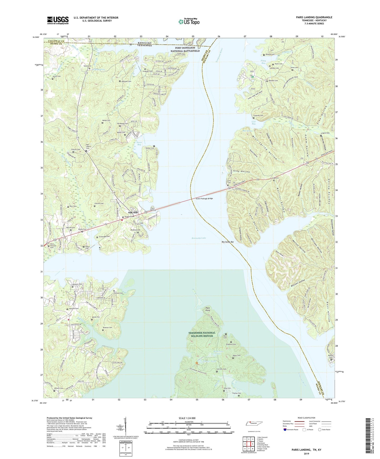
2022 topographic map quadrangle Paris Landing in the states of Tennessee, Kentucky. Scale: 1:24000. Based on the newly updated USGS 7.5' US Topo map series, this map is in the following counties: Henry, Stewart, Calloway. The map contains contour data, water features, and other items you are used to seeing on USGS maps, but also has updated roads and other features. This is the next generation of topographic maps. Printed on high-quality waterproof paper with UV fade-resistant inks.
Quads adjacent to this one:
West: Buchanan
Northwest: New Concord
North: Hamlin
Northeast: Tharpe
East: Standing Rock
Southeast: McKinnon
South: Poplar Creek
Southwest: West Sandy Dike
This map covers the same area as the classic USGS quad with code o36088d1.
Contains the following named places: Abernathy Landing, Antioch Cemetery, Antioch Church, Antioch Landing, Antioch School, Baker Cemetery, Bass Hollow, Bennetts Creek, Betsy Branch, Betsy Spring, Big Eagle Recreation Area, Big Sandy Bar, Big Sandy Island, Big Sandy River, Billie Branch, Bodock Landing, Bradford Cemetery, Bradford Landing, Brannon Cemetery, Brownfield Resort, Buchanan Landing, Buchanans Resort, Bull Durhan Resort Dock, Bunch Hollow, Burtons Landing, Cabana Estates, Campbell Hollow, Causey Hollow, Centerville Landing, Chilcutt Cemetery, Coaling Hollow, Coleman Cemetery, Crutcher Hollow, Cypress Bay Resort, Cypress Creek, Cypress Creek Cabin Area, Dodson Cemetery, Dodson Landing, Dortch Hollow, Dortch Landing, Dover Landing, Driftwood Dock, Dunaway Landing, Eagle Creek, Eagle Nest Marina, Fairview Cemetery, Fairview Church, Fairview School, Farmer Pond, Farmer Pond Dam, Ferguson Cemetery, Gardner Cemetery, Graveyard Hollow, Gray Cemetery, Gray Hollow, Gray School, Grays Landing Lake Access Area, Hamm Hollow, Henderson Branch, Hephzibah Church, Jarrell Cemetery, Kays Landing, LaGrange Landing, Lang Cemetery, Largent Cemetery, Lemond Cemetery, Liberty, Liberty School Number 13, Little Eagle Creek, Lost Bay, Lost Creek, Lost Creek Church, Lumberyard Landing, Lynn Hollow, McGees Landing, Melton Hollow, Mill Dam Hollow, Mint Spring, Mint Spring Hollow, Mitchell Hollow, Mobley, Mobley Cemetery, Mobley hollow, Mobley Landing, Moltkes Landing, Moody Branch, Moody Cemetery, Moores Landing, Morgans Dock, Mount Zion Church, Mouth of Sandy Landing, Mullins Hollow, Mullins School, New Liberty Cemetery, New Liberty Church, Nolen Hollow, North Piney Creek, Oak Haven Acres, Oak Haven Acres Dock, Oak Hill, Oak Hill Cemetery, Oak Hill School, Oak Wood Estates, Old Liberty Church, Old Maple Grove Church, Old Moody Cemetery, Pace, Pace Cemetery, Pace Point, Paris Landing, Paris Landing Fire Department Station 1, Paris Landing Fire Department Station 3, Paris Landing Marina, Paris Landing State Park, Parker Cemetery, Pine Hollow, Pine Point Dock, Piney Bay, Piney Campground, Pleasant Valley School, Point Pleasant Cemetery, Point Pleasant Church, Prairie Branch, Ratteree Cemetery, Rattlesnake Hollow, Red Bank Landing, Reelfoot Girl Scout Council Camp, Rice Cemetery, Riverwood Hills, Robbins Creek, Robertson Lake, Robertson Lake Dam, Ross Branch, Rowlett Cemetery, Rutland Cemetery, Saint Mary Church, Sand Hill Church, Scarbough Cemetery, Scott Fitzhugh Bridge, Shamrock Dock, Shamrock Resort, Short Creek, Sikes Hollow, Slaughters Dock, Snow Cemetery, South Piney Creek, Standing Rock Creek, Standing Rock Dock, Stone Cemetery, Street Cemetery, Sulphur Branch, Swan Bay, Swan Bay Resort Dock, Swan Pond Branch, Swan Pond Swamp, Taylor Cemetery, Thomas Cemetery, Todds Landing, Tupelo Slough, Walker Hollow, Weldon Landing, Williams Cemetery, Williams Dock, Williams Hollow, Wofford Hollow, Woods Cemetery