MyTopo
Mount Pleasant Tennessee US Topo Map
Couldn't load pickup availability
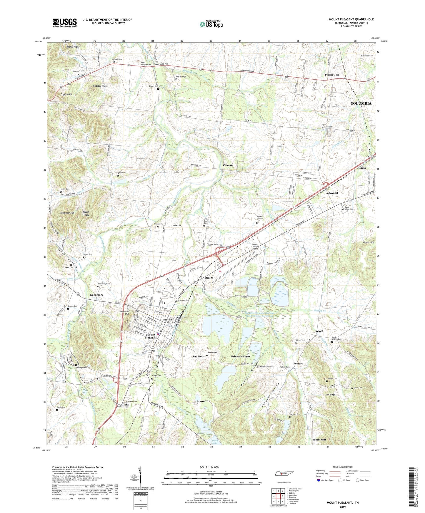
2022 topographic map quadrangle Mount Pleasant in the state of Tennessee. Scale: 1:24000. Based on the newly updated USGS 7.5' US Topo map series, this map is in the following counties: Maury. The map contains contour data, water features, and other items you are used to seeing on USGS maps, but also has updated roads and other features. This is the next generation of topographic maps. Printed on high-quality waterproof paper with UV fade-resistant inks.
Quads adjacent to this one:
West: Mount Joy
Northwest: Greenfield Bend
North: Williamsport
Northeast: Godwin
East: Columbia
Southeast: Lynnville
South: Sandy Hook
Southwest: Summertown
This map covers the same area as the classic USGS quad with code o35087e2.
Contains the following named places: Arlington Cemetery, Arrow, Arrow Lake Dam, Ashwood, Bailey Cemetery, Beard Branch, Bigby, Bobs Lake Number One, Bobs Lake Number One Dam, Bobs Lake Number Two, Bobs Lake Number Two Dam, Bruce Cemetery, Bynum-Williams Cemetery, Camp Branch, Campbell Lake, Campbell Lake Dam, Canaan, Canaan School, Cecil Cemetery, City of Mount Pleasant, Commissioner District 10, Cross Bridges, Cross Bridges Cemetery, Cross Bridges Church, Cross Bridges Junior High School, Cross Cemetery, Davis Mine, Dawson Cemetery, District 10, District 13, District 7, Dog Branch, English Cemetery, English Hill, First Baptist Church of Mount Pleasant, Frierson Town, Gardenia Park, Giddens Cemetery, Ginger Hill, Gipson Hollow, Gipson Hollow Branch, Granberry Cemetery, Grimes Cemetery, Hackney Cemetery, Halls Chapel Church of Christ, Hay Long Elementary School, Hay Long High School, Hills Chapel Cemetery, Hills Chapel School, Hoover-Mason School, Howard Field Park, Howard High School, Hunter Cemetery, Hunter-Kittrell Cemetery, Institute Hill, Isbell, Isbell Branch, James E Woody Elementary School, Jennings Cemetery, Jonesboro, Lawrence Cemetery, Long Branch, Lusk Ridge, Maury County Airport, Maury County Airport Mine, Mayhorn Hollow, McKennan Cemetery, Mount Pleasant, Mount Pleasant City Hall, Mount Pleasant Fire Department Station 2, Mount Pleasant High School, Mount Pleasant Little League Park, Mount Pleasant Police Department, Mount Pleasant Post Office, Mount Pleasant Public Library, Neale Cemetery, Needmore, Patterson Branch, Poplar Top, Porter Cemetery, Porters, Porters Chapel United Methodist Church, Porters School, Pulliam Cemetery, Quality Creek, Red Row, Reservoir Hill, Ridley, Saint Johns Cemetery, Saint Johns Church, Salem Church, Scotts Creek, Shiloh Cemetery, Shiloh Church, Siglo, Spain Cemetery, Stauffer Chemical Dike Number Nineteen, Stauffer Chemical Dike Number Seventeen, Stauffer Chemical Tailings Pond Number Nineteen, Stauffer Chemical Tailings Pond Number Seventeen, Stauffer Globe Pond Dam Number Twenty-one, Stauffer Globe Pond Number Twenty-one, Strayhorn Cemetery, Sugar Creek, Sugar Fork, Tennessee Hill, Thompson Hill, Upper Big Bigby Division, Victor Mine, Virginia-Carolina Mine, Walker-Spatswell Cemetery, Webster Cemetery, Webster Knob, West Fork Big Bigby Creek, West Point Church, Westbrook Church, Westbrook School, Wheeler Hollow, Williams Cemetery, WXRQ-AM (Mount Pleasant), Zion, Zion Cemetery, Zion Presbyterian Church, Zion School, ZIP Code: 38474