MyTopo
Normandy Lake Tennessee US Topo Map
Couldn't load pickup availability
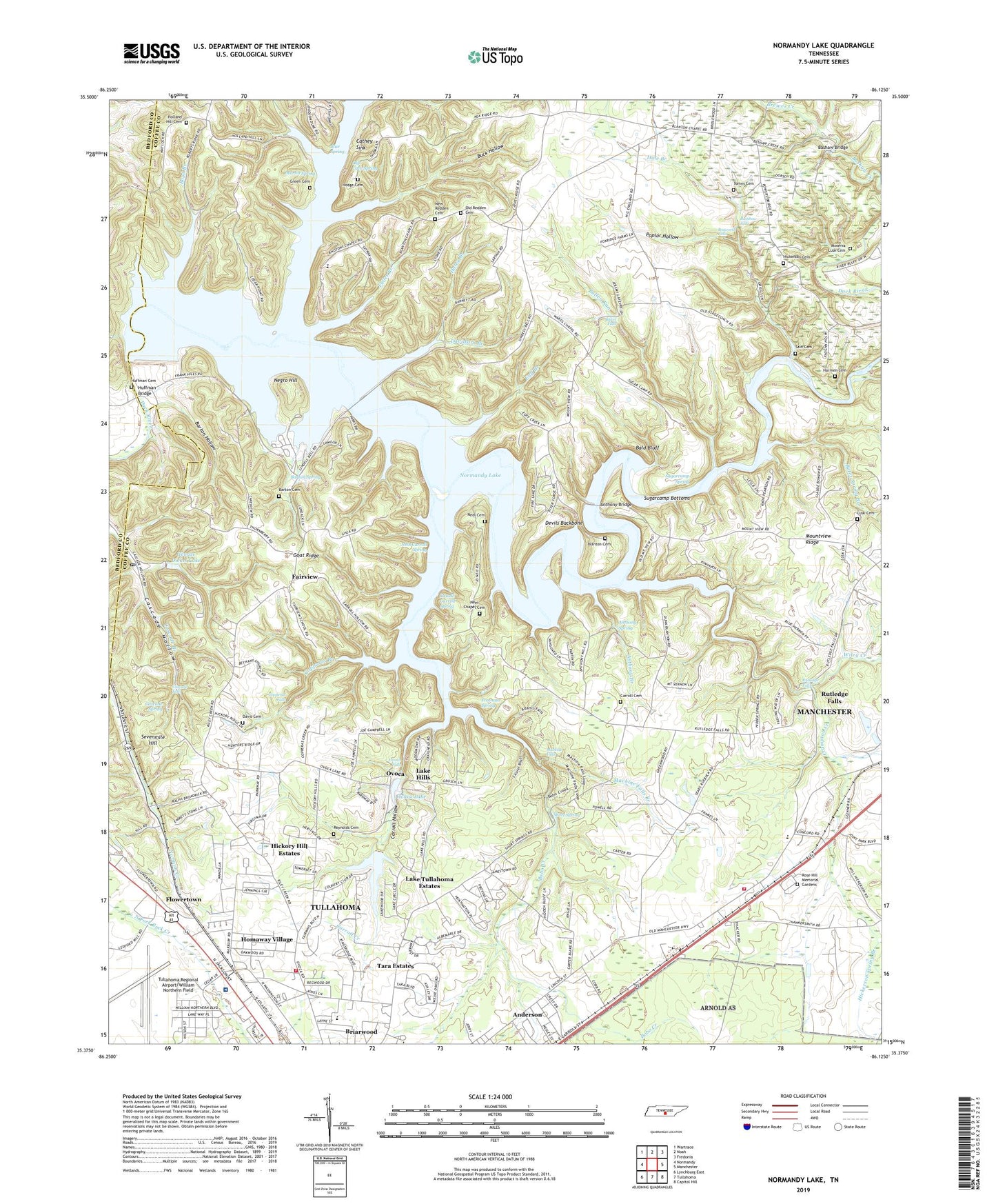
2022 topographic map quadrangle Normandy Lake in the state of Tennessee. Scale: 1:24000. Based on the newly updated USGS 7.5' US Topo map series, this map is in the following counties: Coffee, Bedford. The map contains contour data, water features, and other items you are used to seeing on USGS maps, but also has updated roads and other features. This is the next generation of topographic maps. Printed on high-quality waterproof paper with UV fade-resistant inks.
Quads adjacent to this one:
West: Normandy
Northwest: Wartrace
North: Noah
Northeast: Fredonia
East: Manchester
Southeast: Capitol Hill
South: Tullahoma
Southwest: Lynchburg East
This map covers the same area as the classic USGS quad with code o35086d2.
Contains the following named places: Allen Bridge, Anderson, Anthony Branch, Anthony Bridge, Anthony Spring, Baker Falls, Bald Bluff, Barton Cemetery, Barton Hollow, Barton Spring, Barton Spring Public Use Area, Bashaw Bridge, Bashaw Ford, Bates Spring Branch, Beckman Ford, Bethany Church, Bible Missionary Church, Blanton Cemetery, Blanton Chapel, Blantons School, Blue Spring, Bluff Ford, Bobo Creek, Bobs Cross Roads, Bosworth Falls, Boyd Branch, Brandon Cemetery, Brewer Creek, Briarwood, Buck Hollow, Bullen Run, Camp Bells Mill, Carroll Cemetery, Carroll Creek, Carroll Hollow, Carroll School, Cascade Falls, Cascade Hollow, Cascade Spring, Cat Creek, Cathey Sink, Cedar Point Public Use Area, Cherokee Square Shopping Center, Claude Carroll Spring, Commissioner District 13, Commissioner District 15, Commissioner District 16, Commissioner District 18, Concord Church, Copperas Branch, Copperas Falls, Crumpton Creek, Daniels Mill, Davidson Branch, Davis Cemetery, Denny Waite Bridge, Devils Backbone, Dickel Post Office, Dug Ford, East Middle School, Eoff Branch, Fairview, Fairview School, Flower Town School, Flowertown, Fourth Model Community Center, Fourth Model School, Freeman Spring, Friendship Church, Friendship School, Fuller Branch, George Dickel Dam, George Dickel Lake, Goat Ridge, Goosage Mill, Grace Church, Green Cemetery, Haggard Branch, Hale Branch, Haley Branch, Harmen Cemetery, Harton Regional Medical Center, Hickerson, Hickerson Cemetery, Hickerson Elementary School, Hickerson Spring Branch, Hickerson Station Church, Hickerson Volunteer Fire Department, Hickory Hill Estates, Hiles Bridge, Hodge Cemetery, Holland Hill Cemetery, Homaway Village, Huffman Bridge, Huffman Cemetery, John Carroll Spring, Johnson Cemetery, Jones Elementary School, Lake Hills, Lake Tullahoma, Lake Tullahoma Dam, Lake Tullahoma Estates, Lees Ford, Lincoln Heights Church, Lusk Cemetery, Machine Falls, Machine Falls Branch, Martin Spring, McQuidys Mill, Minerva Lusk Cemetery, Mount Vernon Church of the Nazarene, Mount Vernon School, Mountview Ridge, Mountview School, Neal Ford, Neel Cemetery, Neel Chapel Cemetery, Negro Hill, New Antwerp, New Redden Cemetery, Normandy Dam, Normandy Lake, Old Cave Spring, Old Millrace Ford, Old Redden Cemetery, Ovoca, Ovoca Falls, Ovoca Lake, Ovoca Lake Dam, Ovoca Orphans Home, Parish Aerodrome Airport, Poplar Hollow, Ragan School, Rainbow Falls, Reddens Chapel, Reddens Chapel School, Reynolds Cemetery, Richardson Ford, Riley Creek, Riverside Church, Robert E Lee Elementary School, Rose Hill Memorial Gardens, Rutledge Falls, Rutledge Falls Baptist Church, Sain Cemetery, Sevenmile Hill, Short Spring, Sugarcamp Bottoms, Sugarcamp Ford, Sugarcamp Spring, Tara Estates, Tomes Cemetery, Tullahoma Fire Department Station 2, Tullahoma Golf and Country Club, Tullahoma Regional Airport/William Northern Field, Waite Ford, Ward Chapel, Ward Chapel School, WBGY-FM (Tullahoma), Wesley Heights Church, White Oak Trailer Park, Wiley Creek, William Northern Army Air Field