MyTopo
Tullahoma Tennessee US Topo Map
Couldn't load pickup availability
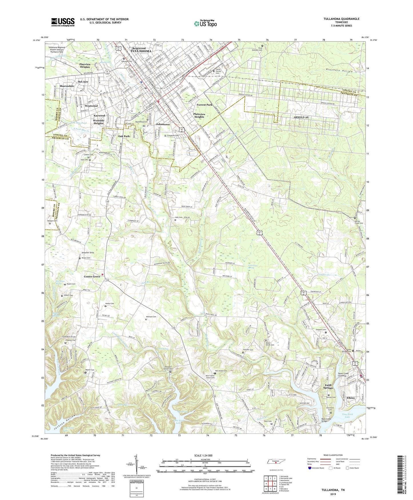
2022 topographic map quadrangle Tullahoma in the state of Tennessee. Scale: 1:24000. Based on the newly updated USGS 7.5' US Topo map series, this map is in the following counties: Franklin, Coffee, Moore. The map contains contour data, water features, and other items you are used to seeing on USGS maps, but also has updated roads and other features. This is the next generation of topographic maps. Printed on high-quality waterproof paper with UV fade-resistant inks.
Quads adjacent to this one:
West: Lynchburg East
Northwest: Normandy
North: Normandy Lake
Northeast: Manchester
East: Capitol Hill
Southeast: Winchester
South: Belvidere
Southwest: Lois
This map covers the same area as the classic USGS quad with code o35086c2.
Contains the following named places: Allen Chapel, Amacher Strip, Atlantic Temple Church of God in Christ, Bel Aire Church of Christ, Bel Aire Elementary School, Bel-Aire, Bethel Baptist Church, Big Spring, Big Spring Park, Blue Creek, Blue Spring, Brandon Training School, Brown Cemetery, Camp Forest Military Reservation, Camp Forrest Cemetery, Center Grove, Center Grove Baptist Church, Center Grove School, Chastain Cemetery, Church of Jesus Christ Pentacostal, City of Tullahoma, Cleek Spring, Clemmons Cemetery, College Street Baptist Church, Commissioner District 17, Commissioner District 19, Commissioner District 20, Commissioner District 21, Commissioner District 7, Crit May Pond, Cummings Spring, Davidson Academy, Dry Creek, Duncan Cemetery, East Junior High School, East Lincoln Elementary School, Elkins, Emmanuel Baptist Church, Emmanuel Church of Christ, Emorys Mill, Estill Springs, Estill Springs Cemetery, Estill Springs City Hall, Estill Springs Division, Estill Springs Park, Estill Springs Police Department, Estill Springs Post Office, Estill Springs School, Estill Springs Volunteer Fire Department, Evergreen Cemetery, Faith Lutheran Church, Faith Temple Church of God in Christ, Fellowship Baptist Church, First Assembly of God Church, First Baptist Church, First Christian Church, First Church of God, First Church of Jesus Christ, First Church of the Nazarene, Fitzgerald and Clarke Preparatory School, Fletcher Cemetery, Forrest Lake, Forrest Park, Frog Chapel, Frog Hollow, Gilbert Cemetery, Gospel Tabernacle, Grundy Street Church of Christ, Heffners Mill, Highland Church, Highland Rim Experimental Farm, Highland Rim School for Girls, Hinkle Cemetery, Holiday Marina and Resort, Holt Cemetery, Hunt Cemetery, Island Ford, Jack T Farrar Elementary School, Jackson Hollow, Jessie Mai Aydelott College, Johnstown, June Branch, Kaywood, Lakeside Estates, Lasater Cemetery, Living Word Fellowship Church, Lowndes Airport, Majors Cemetery, Mangum Cemetery, Maplewood Cemetery, Martin College for Girls, Mount Olivet Cemetery, Mount Olivet Church, Mount Zion Baptist Church, New Awalt Cemetery, New Center Grove Cemetery, New Center Grove Church, New Hope Spring, North Atlantic Street Historic District, North Fork Blue Creek, North Fork Rock Creek, North Franklin County Volunteer Fire Department, Northgate Mall Shopping Center, Oak Park, Oakwood Cemetery, Pineview Heights, Plainview Heights, Pleasant Grove, Pleasant Grove Cemetery, Pleasant Grove Church, Pleasant Grove Public Use Area, Poorhouse Creek, Price Essmann Cemetery, Pylant Cemetery, Pylant Springs, Rock Creek, Rock Creek Bridge, Rock Creek Church, Rock Creek Elementary School, Rock Creek Public Use Area, Saint Barnabas Episcopal Church, Saint Pauls Catholic Church, Saint Pauls Catholic School, Saltwell Hollow, Sarvis Branch, Seventh Day Adventist Church, Sharondale, Shorter Chapel African Methodist Episcopal Church, Simpson Cemetery, South Fork Blue Creek, Southgate Park, Southside Park, Spring Creek Cemetery, Spring Creek Church, Taylor Creek, Taylor Creek Causeway, The Church of Jesus Christ of Latter Day Saints, Town of Estill Springs, Trans Med Ambulance, Trans Med Ambulance Franklin County, Trinity Lutheran Church, Tullahoma, Tullahoma City Hall, Tullahoma Division, Tullahoma Fire Department Station 1, Tullahoma First Baptist Church, Tullahoma First United Methodist Church, Tullahoma First United Presbyterian Church, Tullahoma High School, Tullahoma Plaza Shopping Center, Tullahoma Police Department, Tullahoma Post Office, Tullahoma Public School, Victory Baptist Church, Vine Street Church of God, Waggoner Memorial Park, WBGY-AM (Tullahoma), West End Baptist Church, West Fork Rock Creek, West Junior High School, Westside Church of the Nazarene, Westside Heights, Westside United Pentacostal Church, Westwood, Westwood Church of Christ, Whites Mill, Wilson Avenue Church of Christ, Womack Cemetery, Woolwine School, ZIP Codes: 37330, 37388