MyTopo
Normandy Tennessee US Topo Map
Couldn't load pickup availability
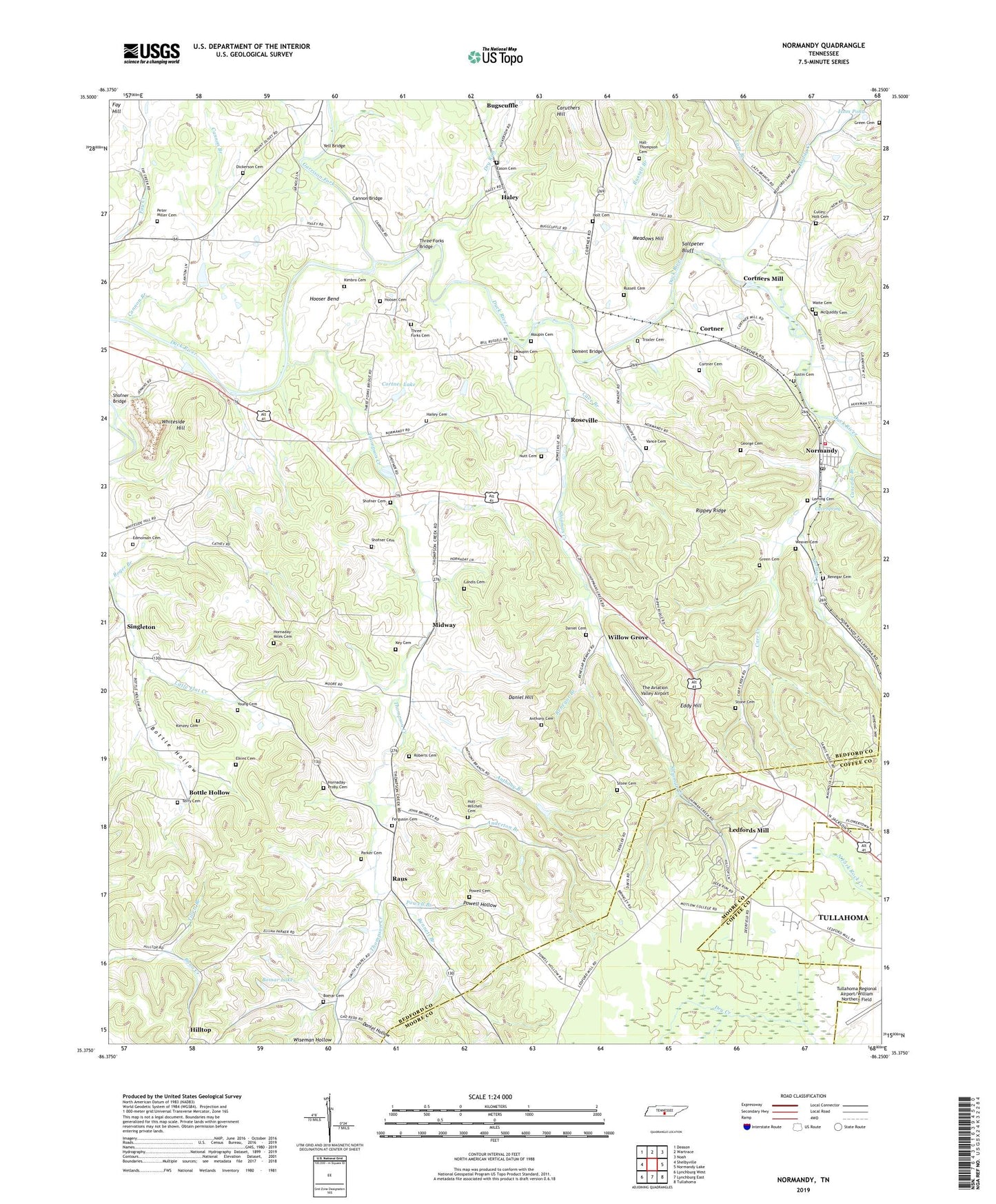
2022 topographic map quadrangle Normandy in the state of Tennessee. Scale: 1:24000. Based on the newly updated USGS 7.5' US Topo map series, this map is in the following counties: Bedford, Moore, Coffee. The map contains contour data, water features, and other items you are used to seeing on USGS maps, but also has updated roads and other features. This is the next generation of topographic maps. Printed on high-quality waterproof paper with UV fade-resistant inks.
Quads adjacent to this one:
West: Shelbyville
Northwest: Deason
North: Wartrace
Northeast: Noah
East: Normandy Lake
Southeast: Tullahoma
South: Lynchburg East
Southwest: Lynchburg West
This map covers the same area as the classic USGS quad with code o35086d3.
Contains the following named places: Anderton Branch, Anthony Branch, Anthony Cemetery, Austin Cemetery, Bennett Branch, Bomar Cemetery, Bomar Lake, Bomar Lake Dam, Bottle Hollow, Bugscuffle, Cannon Branch, Cannon Bridge, Carr Creek, Caruthers Hill, Cascade Branch, Cave Branch, Cave Spring, Cortner, Cortner Cemetery, Cortner Lake, Cortner Lake Dam, Cortners Mill, Culley-Holt Cemetery, Daniel Cemetery, Daniel Hill, Daniel Hollow, Dement Bridge, Dickerson Cemetery, Doddy Creek, Dry Run, Eason Cemetery, Eddy Hill, Edmonson Cemetery, Elkins Cemetery, Ferguson Cemetery, Flat Creek-Normandy Division, Garrison Fork, George Cemetery, Gordon Branch, Green Cemetery, Hailey Cemetery, Haley, Haley School, Hall-Thompson Cemetery, Holt Cemetery, Holt-Mitchell Cemetery, Hooser Bend, Hooser Cemetery, Hornaday-Miles Cemetery, Hornaday-Proby Cemetery, Isom Pond, Key Cemetery, Kimbro Cemetery, Kimzey Cemetery, Landis Cemetery, Lazy Branch, Ledfords Mill, Leming Cemetery, Maupin Cemetery, McQuiddy Cemetery, Meadows Hill, Midway, Mount Olive Church, Mount Olivet United Methodist Church, Mount Zion Church, Mullins Mill, Norman Creek, Normandy, Normandy First Baptist Church, Normandy Historic District, Normandy Post Office, Normandy School, Normandy United Methodist Church, Nutt Cemetery, Parker Cemetery, Peter Miller Cemetery, Powell Branch, Powell Cemetery, Powell Hollow, Quail Hollow Landfill, Raus, Raus Church of Christ, Raus School, Renegar Branch, Renegar Cemetery, Rippey Ridge, Roberts Cemetery, Roberts Chapel, Rocky Point Church, Roger Branch, Roseville, Rowesville United Methodist Church, Russell Branch, Russell Cemetery, Rutledge Field, Saltpeter Bluff, Shipman Creek, Shipmans Creek School, Shofner Bridge, Shofner Cemetery, Shofner Church, Shorts Store, Singleton, Singleton Baptist Church, Singleton Methodist Church, Singleton School, Stone Cemetery, Terry Cemetery, The Aviation Valley Airport, The Stone Man Quarry, Thompson Creek, Thompson Creek Baptist Church, Three Forks Bridge, Three Forks Cemetery, Three Forks Church, Three Forks Mill, Tillett Branch, Town of Normandy, Troxler Cemetery, Vance Cemetery, Volunteer Fire Services Station 4 - Normandy Volunteer Fire Department, Waite Cemetery, Weaver Cemetery, Whiteside Hill, Willow Grove, Willow Grove School, Wiseman Hollow, Yell Bridge, Young Cemetery, ZIP Codes: 37183, 37360