MyTopo
Riverside Tennessee US Topo Map
Couldn't load pickup availability
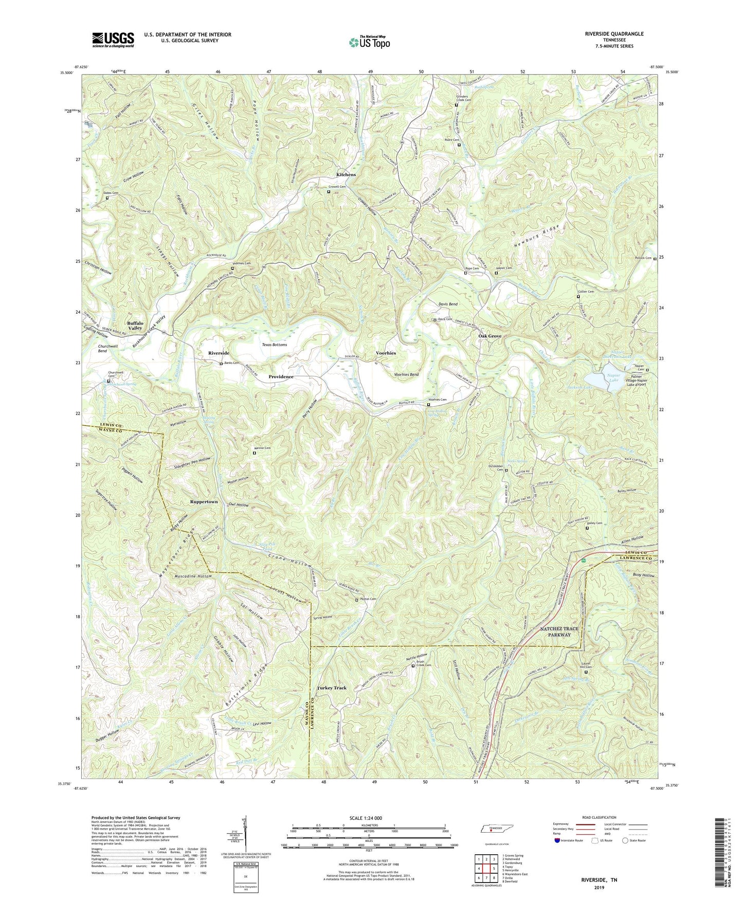
2022 topographic map quadrangle Riverside in the state of Tennessee. Scale: 1:24000. Based on the newly updated USGS 7.5' US Topo map series, this map is in the following counties: Lewis, Wayne, Lawrence. The map contains contour data, water features, and other items you are used to seeing on USGS maps, but also has updated roads and other features. This is the next generation of topographic maps. Printed on high-quality waterproof paper with UV fade-resistant inks.
Quads adjacent to this one:
West: Topsy
Northwest: Graves Spring
North: Hohenwald
Northeast: Gordonsburg
East: Henryville
Southeast: Deerfield
South: Ovilla
Southwest: Waynesboro East
This map covers the same area as the classic USGS quad with code o35087d5.
Contains the following named places: Alf Branch, Allen Hollow, Allens Creek, Allens Creek Mines, Ash Spring Branch, Bailey Cemetery, Bailey Hollow, Banks Cemetery, Barber Branch, Bill Branch, Blowing Spring, Bold Branch, Brown Branch, Brown Prospect, Brush Creek, Brush Creek Bank Prospect Number One, Brush Creek Bank Prospect Number Two, Brush Creek Bank Prospect Three, Brush Creek Cemetery, Buffalo Valley, Buffalo Valley School, Buffalo Valley United Methodist Church, Buoy Hollow, Buttermilk Ridge, Cedar Bluff Branch, Chief Creek, Christian Hollow, Christian Prospect Number Four, Christian Prospect Number One, Christian Prospect Number Three, Christian Prospect Number Two, Christian-Floyd Prospect, Churchwell Bend, Churchwell Cemetery, Churchwell Ford, Churchwell Spring, Civilian Conservation Corps Camp Number 1472, Coaling Hollow, Collier Cemetery, Commissioner District 5, Cow Hollow Branch, Cow Hollow Spring, Crane Hollow, Crow Hollow, Crowell Cemetery, Crowell Hollow, Crowl Branch, Dabbs Cemetery, Davis Bend, Davis Cemetery, Davis Ford, Dirtdobber Cemetery, Dry Branch, Fall Hollow, Falls Hollow, Gildridge Branch, Giles Hollow, Gobble Hollow, Grinders Creek, Grinders Creek Cemetery, Grinders Creek Church, Howard, Hurricane Branch, Jacks Branch, Jacks Branch-Rockhouse Creek Prospects, Jackson Dam, Jackson Lake, John Hollow, Keeling Branch, Kitchens, Laurel Hill, Laurel Hill Cemetery, Levi Hollow, Little Allens Creek, Little Brush Creek, Little Buffalo River, Locust Hollow, Mannie Cemetery, Manny Furnace, Maple Valley School, McLean, Metal Ford, Morton Prospect, Muscadine Hollow, Nancy, Napier Cemetery, Napier Dam, Napier Diversion Dam, Napier Diversion Lake, Napier Lake, Nettle Hollow, Newburg Ridge, Nichols Branch, Nicks Spring, Nixon Craig Prospect, Oak Grove, Oak Grove Church, Owl Hollow, Palmer Village-Napier Lake Airport, Payton Cemetery, Percy Mines, Perry Hollow, Pine Bluff Branch, Pine Bluff Branch Prospect, Pollock Cemetery, Poore Cemetery, Pope Cemetery, Pope Hollow, Providence, Providence Church, Providence School, Ramsey Branch, Red Dirt Branch, Reed Branch, Riverside, Riverside Church, Riverside School, Rochell-Slayden Prospect, Rockhouse Creek, Rockhouse Creek Valley, Rockhouse Hollow, Rocky Hollow, Ruppertown, Rush Branch, Rush Spring, Sal Hollow, Schoolhouse Hollow, Simmons Gin Branch, Slag Pile Pond, Slaughter Pen Hollow, Smith Prospect, Spring Hollow, Staggs Hollow, Still Hollow, Strathmore, Texas Bottoms, Trace Creek, Turkey Track, Turkey Track Church, Turkey Track School, Turkeypen Branch, Voorhies, Voorhies Bend, Voorhies Cemetery, Washer Hollow, Watery Branch, Waynesboro Ridge, Wye Hollow