MyTopo
Ten Mile Tennessee US Topo Map
Couldn't load pickup availability
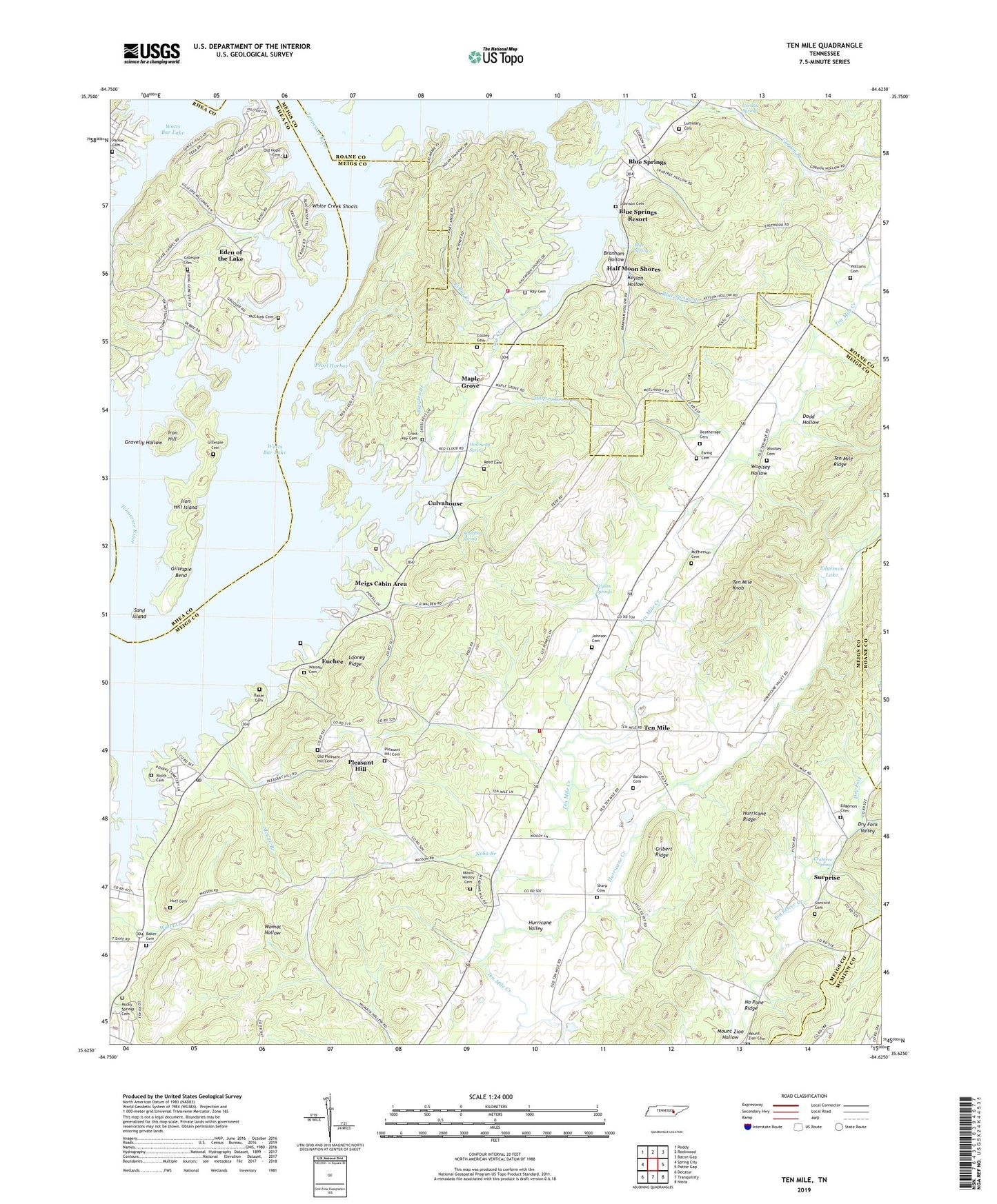
2022 topographic map quadrangle Ten Mile in the state of Tennessee. Scale: 1:24000. Based on the newly updated USGS 7.5' US Topo map series, this map is in the following counties: Meigs, Roane, Rhea, McMinn. The map contains contour data, water features, and other items you are used to seeing on USGS maps, but also has updated roads and other features. This is the next generation of topographic maps. Printed on high-quality waterproof paper with UV fade-resistant inks.
Quads adjacent to this one:
West: Spring City
Northwest: Roddy
North: Rockwood
Northeast: Bacon Gap
East: Pattie Gap
Southeast: Niota
South: Tranquillity
Southwest: Decatur
This map covers the same area as the classic USGS quad with code o35084f6.
Contains the following named places: Apollo Shores, Arrowhead Dock, Baker Cemetery, Baldwin Cemetery, Bayside, Bayside Dock, Big Springs Access Area, Bills Pier, Blue Spring, Blue Spring Branch, Blue Springs, Blue Springs Dock, Blue Springs Resort, Bowdens Store, Branham Hollow, Camp Oo-tah-nee-noh-chee, Campground on the Lakeshore, Cane Creek, Cedine Bible Camp, Commissioner District 5, Concord Cemetery, Concord Church, Concord School, Cooley Cemetery, Crabtree Spring, Cross Key Cemetery, Cross Key Chapel, Culvahouse, Culvahouse Cemetery, Deatherage Cemetery, Dodd Hollow, Dry Fork, Dry Fork Valley, Eden of the Lake, Edgemon Cemetery, Edgemon Church, Edgemon Lake, Euchee, Euchee Chapel, Euchee Dock, Euchee Old Fields, Euchee School, Evans Branch, Ewing Cemetery, Ewings School, Fellowship Baptist Church, Gilbert Ridge, Gillaspies Ferry, Gillespie Bend, Gillespie Cemetery, Gordon Spring, Gravelly Hollow, Half Moon Shores, Holloway Spring, Hornsby Chapel Cemetery, Hornsby Hollow Recreation Area, Hornsbys Chapel Methodist Church, Huff Cemetery, Hurricane Creek, Hurricane Valley, Iron Hill, Iron Hill Island, Johnson Cemetery, Keylon Hollow, Keylon Springs, Looney Ridge, Luminary Cemetery, Maple Grove, Maple Grove Church, Marney Creek, Mary Crabtree School, McCaleb Cemetery, McCall Branch, McPherson Cemetery, Meigs Cabin Area, Meigs County Emergency Services Fire Rescue Station 5, Morris Island, Mount Wesley Cemetery, Mount Wesley Methodist Church, Mount Zion Cemetery, Nebo Branch, No Pone Ridge, Old Hope Cemetery, Old Pleasant Hill Cemetery, Old Ten Mile Cemetery, Parker Cemetery, Peakland Church, Pearl Harbor, Pleasant Hill, Pleasant Hill Baptist Church Cemetery, Pleasant Hill Methodist Church, Pleasant Hill School, Ponderosa Resort, Ray Cemetery, Rector Branch, Red Cloud Campground, Reed Cemetery, Rocky Springs Cemetery, Rocky Springs Church, Roork Cemetery, Rowden Branch, Sams Dock, Sand Island, Sensaboy Spring, Sharp Cemetery, South Roane County Volunteer Fire Department Station 5 Half Moon Shores Fire Station, Stump Hollow Campground, Surprise, Tabor, Ten Mile, Ten Mile Division, Ten Mile Elementary School, Ten Mile Knob, Ten Mile Methodist Church, Ten Mile Post Office, Ten Mile Ridge, Terrace View Resort, Wann Branch, Wasson Cemetery, Watts Bar Estates, White Creek Shoals, Williams Cemetery, Woodys Mill, Woolsey Cemetery, Woolsey Hollow, ZIP Code: 37880