MyTopo
Decatur Tennessee US Topo Map
Couldn't load pickup availability
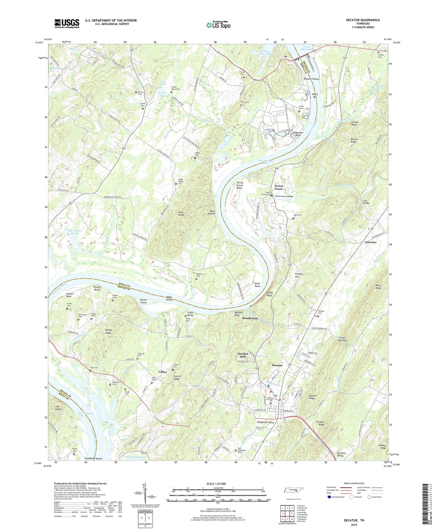
2022 topographic map quadrangle Decatur in the state of Tennessee. Scale: 1:24000. Based on the newly updated USGS 7.5' US Topo map series, this map is in the following counties: Meigs, Rhea, McMinn. The map contains contour data, water features, and other items you are used to seeing on USGS maps, but also has updated roads and other features. This is the next generation of topographic maps. Printed on high-quality waterproof paper with UV fade-resistant inks.
Quads adjacent to this one:
West: Evensville
Northwest: Pennine
North: Spring City
Northeast: Ten Mile
East: Tranquillity
Southeast: Riceville
South: Goodfield
Southwest: Big Spring
This map covers the same area as the classic USGS quad with code o35084e7.
Contains the following named places: Asbury Chapel, Ball Cemetery, Blalock Ridge, Blue Spring Slough, Bogles Chapel, Bogles Chapel School, Breedenton, Buck Hollow, Burttram Cemetery, Bush Creek, Butcher Bluff, Calico, Calvary Church, Carp School, Carpenter Spring, Cave Spring, Clear Creek, Commissioner District 3, Concord Cemetery, Concord Church, Concord School, Cooke Cemetery, Cooke Landing, Cooley Cemetery, Correll Cemetery, Correll Ridge, Dake Branch, DeArmond Cemetery, Decatur, Decatur Branch, Decatur Cemetery, Decatur Church of God, Decatur Division, Decatur Fire Department Station 1, Decatur Fire Department Station 2, Decatur First Baptist Church, Decatur Hills, Decatur Post Office, Decatur Ridge, Decatur United Methodist Church, Ditney Ridge, Dry Branch, Eaves Bluff, Eaves Cemetery, Eaves Spring, Englerock Landing, Eves Ferry, Ewing Cemetery, Fairview, Fairview Elementary School, Five Point Church, Forest Grove, Forest Grove Bend, Forest Grove Bridge, Forest Grove Cemetery, Forest Grove School, Guinn Narrows, Henleys Mill, Hunter Bend, Hunter Bluff, Hunter Cemetery, Hunter Island, Hutsell Branch, Ingle Cemetery, Ingle Rocks, Iron Bridge, Iron Bridge School, Johns Chapel, Kincaid Spring, Kings Mill, Leuty Cemetery, Lick Branch, Lillard Bluff, M and M Dock, McDonald Bend, McDonald School, McKinley Branch, McPherson Landing, Meigs County, Meigs County Courthouse, Meigs County School, Meigs County Sheriff Department, Moss Fishing Dock, No Pone Ridge, Old Goodfield Cemetery, Old Stewarts Landing, Piney River Shoals, Pinhook Ferry, Poe Branch, Poe Cemetery, Porter - Ward Cemetery, Porter Cemetery, Porter Lake, Porter Lake Dam, Powers Landing, Presley Hill, Prices Ferry, River Knobs, Seventh Day Adventist Church, Sewee Creek, Sewee Iron Works, Sewee Landing, Sims Cemetery, Slabtown, Smith - Wilkey Cemetery, Smith Bend, Smith Cemetery, Stewart Branch, Stewart Cemetery, Stewarts Chapel, Stumptoe School, Tadpole Branch, Taylor Cemetery, Texas Grove Church, Town of Decatur, Vineyard Landing, Waltons Islands, Waltons Shoals, Ward Ridge, Ward Spring, Watkins Cemetery, Watts Bar, Watts Bar Dam, Watts Bar Dam Post Office, Watts Bar Nuclear Plant, Watts Bar Resort, Watts Bar Steam Plant, Watts Creek, Wells Shoals, Yellow Creek, Yellow Creek Church, Yellow Creek Fish Hatchery, Yellow Creek Wildlife Management Area, ZIP Code: 37322