MyTopo
Waynesboro East Tennessee US Topo Map
Couldn't load pickup availability
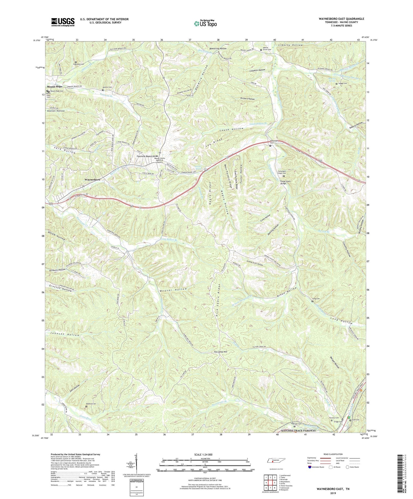
2019 topographic map quadrangle Waynesboro East in the state of Tennessee. Scale: 1:24000. Based on the newly updated USGS 7.5' US Topo map series, this map is in the following counties: Wayne. The map contains contour data, water features, and other items you are used to seeing on USGS maps, but also has updated roads and other features. This is the next generation of topographic maps. Printed on high-quality waterproof paper with UV fade-resistant inks.
Quads adjacent to this one:
West: Waynesboro
Northwest: Leatherwood
North: Topsy
Northeast: Riverside
East: Ovilla
Southeast: Westpoint
South: Collinwood
Southwest: Three Churches
Contains the following named places: Barlow Branch, Barnett Branch, Bedford Cemetery, Blowing Spring, Blowing Springs Creek, Blowing Springs School, Broach Mine, Buchanan Prospects, Churchwell Prospects, Cole Cemetery, Commissioner District 1, Commissioner District 7, Copeland Cemetery, Crews Hollow, Crews Mine, Deering Hollow, Dick Cabin Ridge, Dixon Hollow, Dunmire Hollow, East Furnace Ridge, East Furnace Ridge Mine, Factory Cemetery, Fall Branch, Flat Hollow, Forge Stack Bridge, Fortyeight Cemetery, Fortyeight Creek Bridge, Fortyeight Creek Bridge School, Fortyeight Creek School, Fortyeight Forge, Fortyeight Forge Cemetery, Fortyeight Freewill Baptist Church, Foster Hollow, Foster Hollow Prospect, Fourmile Board Hill, Furnace Branch, Geissler Spring, Granny Scott Hollow, Griggs Cemetery, Hurricane School, Irontop Mine, John Hollow, Keaton Springs Mine, Keeton Cemetery, Lee Hollow, Lee Hollow Mines, Lee Ridge, Lee Ridge Mines, Liberty Church, Liberty Hollow, Limekiln Hollow, Little Fortyeight Creek, Long Cemetery, Long Hollow, Long Hollow Branch, Louse Hollow, Louse Hollow Branch, Mc Gee Cemetery, Morgan Hollow, Mount Hope, Mount Hope Cemetery, Mount Hope Christian Church, Mount Hope Methodist Church, Mount Hope School, Murphy Hollow, Murphy Mine, Negro Hollow, Negro Ridge, Negro Ridge Mine, Nutt Prospect, Oldtown Branch, Orchard Hollow, Perigo Mine, Raburn Hollow, Robinette Prospect, Sapling Mine, Shell Church, South Fork Blowing Springs Creek, Staggs Cemetery, Stoeball Branch, Sweetwater Branch, Tie Camp Hill, Timothy Hollow, Walnut Grove Cemetery, Wayne County Memorial Gardens, Wayne Furnace, Waynesboro Division, Weaver Hollow, West Fork Fortyeight Creek, West Furnace Ridge, West Furnace Ridge Mine, West Mine, WNBG-AM (Waynesboro)