MyTopo
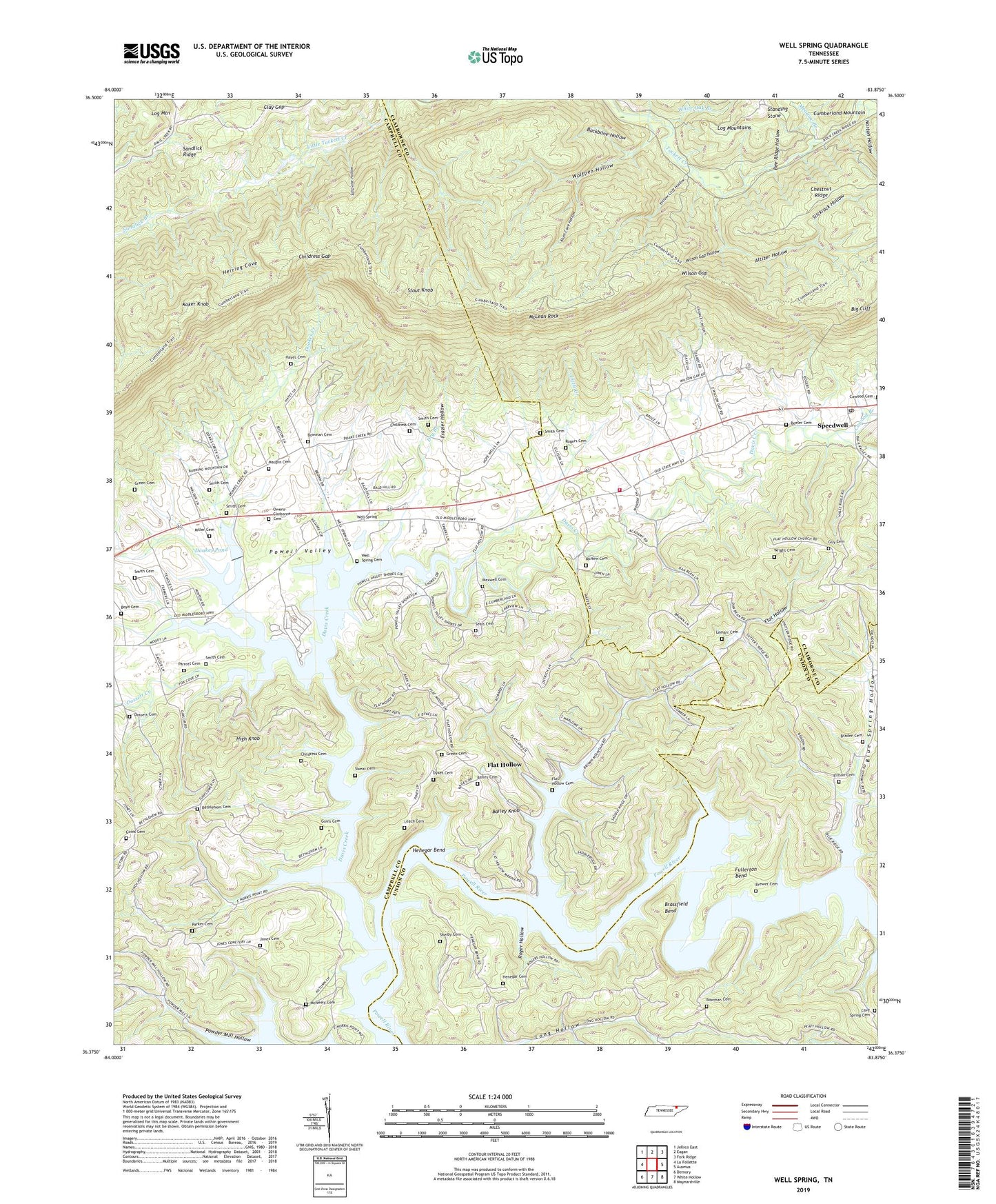
Well Spring Tennessee US Topo Map
Couldn't load pickup availability
2019 topographic map quadrangle Well Spring in the state of Tennessee. Scale: 1:24000. Based on the newly updated USGS 7.5' US Topo map series, this map is in the following counties: Campbell, Claiborne, Union. The map contains contour data, water features, and other items you are used to seeing on USGS maps, but also has updated roads and other features. This is the next generation of topographic maps. Printed on high-quality waterproof paper with UV fade-resistant inks.
Quads adjacent to this one:
West: La Follette
Northwest: Jellico East
North: Eagan
Northeast: Fork Ridge
East: Ausmus
Southeast: Maynardville
South: White Hollow
Southwest: Demory
Contains the following named places: Altizer Hollow, Alum Cave Hollow, Backbone Hollow, Bailey Cemetery, Bailey Knob, Bee Ridge Hollow, Beeler Cemetery, Bethlehem, Bethlehem Baptist Church, Bethlehem Cemetery, Bethlehem School, Big Cliff, Blue Spring Hollow, Blue Springs Hollow Dock, Bowman Cemetery, Boyd Cemetery, Braden, Braden Cemetery, Braden School, Brassfield Bend, Brewer Cemetery, Cave Spring Cemetery, Cave Spring Church, Cawood Branch, Cawood Cemetery, Cawood School, Cawood United Methodist Church, Chestnut Ridge, Childress Cemetery, Childress Gap, Clay Gap, Davis Creek, Doakes Creek, Doakes Creek Dam, Doakes Pond, Dossett Cemetery, Dossett Creek, Dry Branch, Dykes Cemetery, Ellison Cemetery, Flat Hollow, Flat Hollow Boat Dock, Flat Hollow Cemetery, Flat Hollow Church, Flat Hollow School, Frazier Hollow, Fullerton Bend, Goins Cemetery, Green Cemetery, Greens Ford, Guy Cemetery, Hayes Cemetery, Henegar Bend, Henegar Cemetery, Herring Cove, High Knob, Jones Cemetery, Koker Knob, Leach Cemetery, Lemarr Cemetery, Little Creek, Log Mountain, Long Hollow, Long Hollow School, Maupin Cemetery, Maxwell Cemetery, McLean Rock, McNeely Cemetery, McNew Cemetery, Meadow Branch, Miller Cemetery, No Business Hollow, Norton Hollow, Owens-Claiborne Cemetery, Parker Cemetery, Parrott Cemetery, Phebe, Pine Grove Church, Powder Mill Hollow, Powell Valley Conservation League Camp, Powell Valley Resort and Marina, Roger Hollow, Rogers Cemetery, Rogers Dock, Saltpeter Hollow, Sandlick Ridge, Seals Cemetery, Shelby Cemetery, Slickrock Hollow, Smith Cemetery, Speedwell Academy, Speedwell Academy Baptist Church, Speedwell Freewill Baptist Church, Speedwell Post Office, Speedwell Volunteer Fire Department Station 2, Standing Stone, Stockville, Stout Knob, Sweat Cemetery, Upper Flat Hollow School, Well Spring, Well Spring Cemetery, Well Springs Church of God, Well Springs School, Well Springs United Methodist Church, White Oak Branch, Wilson Gap, Wilson Gap Hollow, Wolfpen Hollow, Wright Cemetery, Yellow Cliff Hollow