MyTopo
South Pittsburg Tennessee US Topo Map
Couldn't load pickup availability
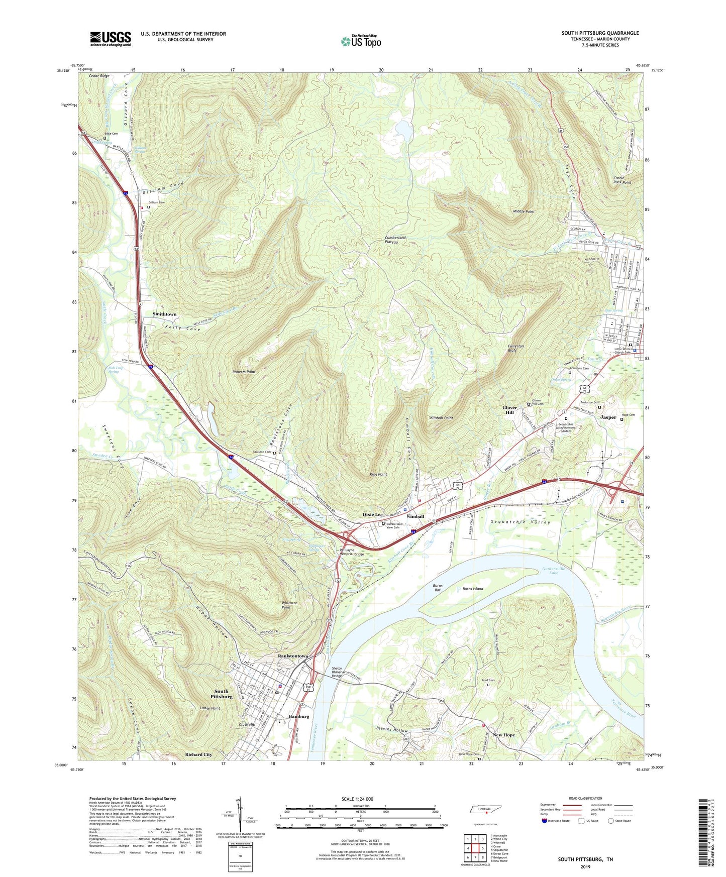
2022 topographic map quadrangle South Pittsburg in the state of Tennessee. Scale: 1:24000. Based on the newly updated USGS 7.5' US Topo map series, this map is in the following counties: Marion. The map contains contour data, water features, and other items you are used to seeing on USGS maps, but also has updated roads and other features. This is the next generation of topographic maps. Printed on high-quality waterproof paper with UV fade-resistant inks.
Quads adjacent to this one:
West: Orme
Northwest: Monteagle
North: White City
Northeast: Whitwell
East: Sequatchie
Southeast: New Home
South: Bridgeport
Southwest: Doran Cove
This map covers the same area as the classic USGS quad with code o35085a6.
Contains the following named places: Alleys Ferry, Anderson Cemetery, Antioch Church, Battle Creek, Battle Creek Institute, Battle Creek Volunteer Fire Department, Beene Cove, Beene Stadium, Beene-Pearson Memorial Library, Bethel African Methodist Episcopal Church, Bible Cemetery, Bible Spring, Big Fiery Gizzard Creek, Blevins Hollow, Blue Spring, Browder Switch Industrial Park, Burns Bar, Burns Island, Calvary Baptist Church, Castle Rock Point, Cedar Ridge, Chaudoin Cemetery, Christ Episcopal Church, City of New Hope, City of South Pittsburg, Clute Hill, Cumberland View Cemetery, Dixie Lee, Druin Spring, Ebenezer Church, Faith Baptist Church, Faith Christian Academy, Fish Trap Ford, Fish Trap Spring, Ford Cemetery, Fullerton Bluff, Gilliam Cemetery, Gilliam Cove, Gilliam Spring, Gizzard Cove, Glover Branch, Glover Hill, Glover Hill Cemetery, Glover Hill Church of God, Grahams Ferry, Grandview EMS, Hamburg, Happy Hollow, Hightower Spring, Hise Cove, Hoge Cemetery, Holly Avenue United Methodist Church, Jasper, Jasper Church of Christ, Jasper Cumberland Presbyterian Church, Jasper First Baptist Church, Jasper Middle School, Jasper Post Office, Jasper Public Library, Kelly Cove, Kelly Cove Branch, Ketchall, Ketchall Quarry, Ketchalls Ford, Kimball, Kimball Baptist Church, Kimball Church of Christ, Kimball Cove, Kimball Cove Branch, Kimball Fire and Rescue Department, Kimball Point, Kimball Police Department, Kimball School, Kimball Station, King Point, King Spring, Kings Ford, Little Bethel Church, Little White Church, Little White Church Cemetery, Lodge Point, Lowrys Ferry, Loyd Park, Marion County Courthouse, Marion County Sheriff's Office, McDaniel Annex Church, Middle Point, Monteagle-South Pittsburg Division, Mount Bethelehem Baptist Church, Mount Olive Primitive Baptist Church, Mount Vernon Church, New Hope, New Hope Cemetery, New Hope Fire Department, New Hope School, Our Lady of Lourdes Catholic Church, Parkridge West Hospital, Pat Layne Memorial Bridge, Patton School, Pinhook, Pryor Cove, Raulston Branch, Raulston Cemetery, Raulstons Cove, Raulstontown, Richard City Quarry, Roberts Point, Sequatchie River, Sequatchie Valley, Sequatchie Valley Golf and Country Club, Sequatchie Valley Memorial Gardens, Shelby Rhinehart Bridge, Smithtown, South Pittsburg, South Pittsburg Church of Christ, South Pittsburg Church of the Nazarene, South Pittsburg City Hall, South Pittsburg Cumberland Presbyterian Church, South Pittsburg Ferry, South Pittsburg First Baptist Church, South Pittsburg High School, South Pittsburg Historic District, South Pittsburg Municipal Hospital, South Pittsburg Municipal Park, South Pittsburg Police Department, South Pittsburg Post Office, South Pittsburg Primitive Baptist Church, South Pittsburg School, South Pittsburg Volunteer Fire Department, Standifer Branch, Sweden Creek, Sweetens Cove, Town of Kimball, Wells Chapel United Methodist Church, WEPG-AM (South Pittsburg), Wesley Methodist Church, West Fork Pryor Cove Branch, Whitacre Point