MyTopo
Sequatchie Tennessee US Topo Map
Couldn't load pickup availability
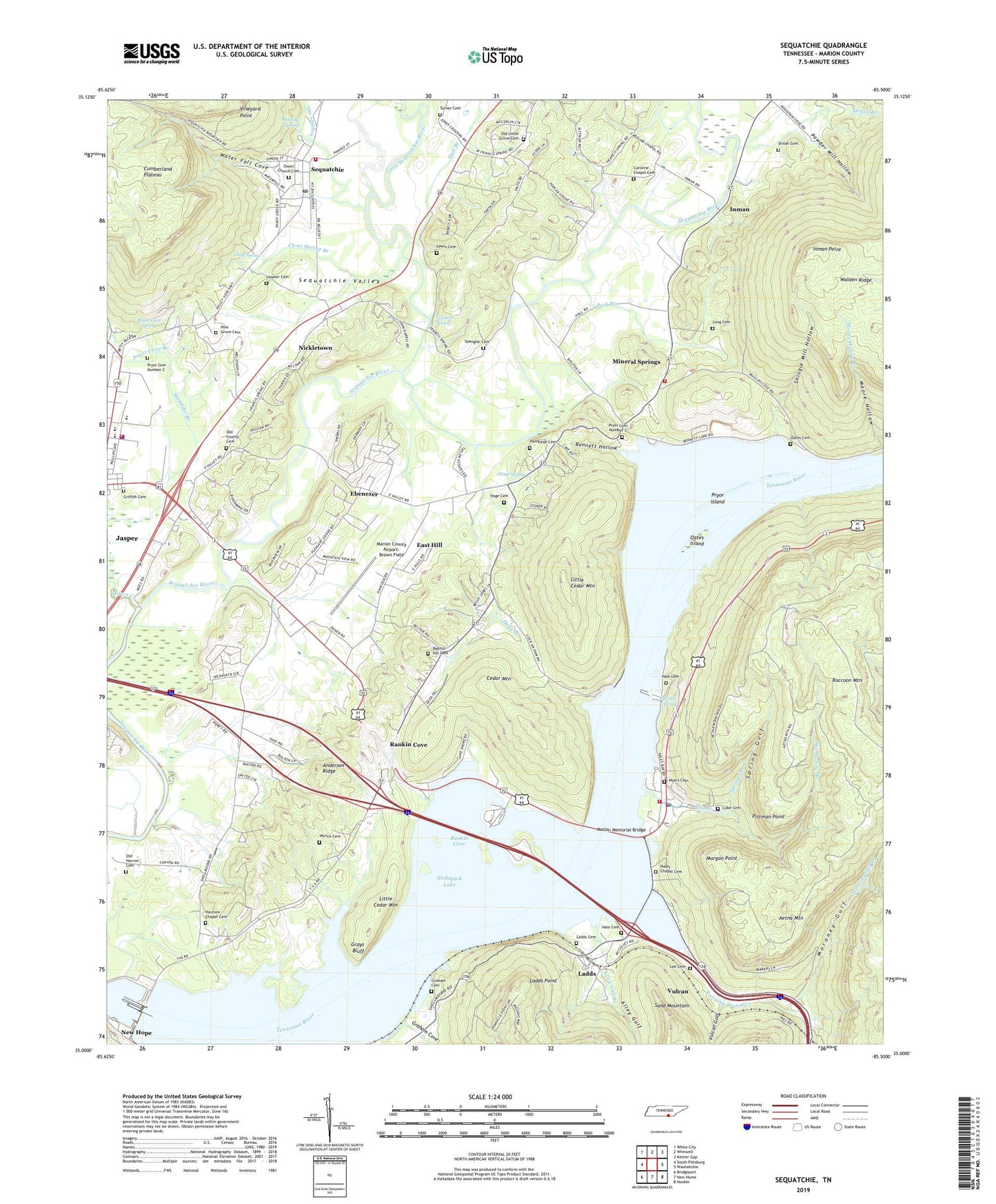
2022 topographic map quadrangle Sequatchie in the state of Tennessee. Scale: 1:24000. Based on the newly updated USGS 7.5' US Topo map series, this map is in the following counties: Marion. The map contains contour data, water features, and other items you are used to seeing on USGS maps, but also has updated roads and other features. This is the next generation of topographic maps. Printed on high-quality waterproof paper with UV fade-resistant inks.
Quads adjacent to this one:
West: South Pittsburg
Northwest: White City
North: Whitwell
Northeast: Ketner Gap
East: Wauhatchie
Southeast: Hooker
South: New Home
Southwest: Bridgeport
This map covers the same area as the classic USGS quad with code o35085a5.
Contains the following named places: Aetna Mountain, Alley Gulf, Alley Gulf Branch, Amazing Grace Chapel, Anderson Ridge, Baptist Hill Cemetery, Baptist Hill Church, Bennett Hollow, Bennett Lake, Bennetts Lake Quarry, Blowing Spring, Blowing Spring Park, Cabe Cemetery, Caroline Chapel, Caroline Chapel Cemetery, Cedar Mountain, Clear Spring, Clear Spring Branch, Commissioner District 3, Dry Creek, East Hill, Ebenezer, Ebenezer Church, Ebenezer School, Francis Spring, Francis Spring School, Gardenhires Ferry, Graham Cemetery, Graham Cove, Graham Cove Branch, Grays Bluff, Griffith Cemetery, Guild First Baptist Church, Guild Post Office, Guild School, Hale Cemetery, Hales Bar Dam, Hales Bar Power Plants, Hales Bar Resort and Marina, Hales Chapel Cemetery, Hales Chapel United Methodist Church, Haletown, Haletown Volunteer Fire Department, Hall Branch, Halls Ferry, Havron Chapel, Havrons Chapel Cemetery, Hix Hollow Branch, Hoge Branch, Hoge Cemetery, Hoge Spring, Hornbeak Cemetery, Inman, Inman Mine, Inman Point, Jasper Church of the Nazarene, Jasper City Hall, Jasper City Park, Jasper Division, Jasper Elementary School, Jasper Fire Department, Jasper Police Department, Jasper School, Jasper Seventh Day Adventist Church, Kelleys Mill, Killian School, Knox School, Ladds, Ladds Cemetery, Ladds Point, Lasater Cemetery, Lee Cemetery, Lewis Cemetery, Little Cedar Mountain, Little Sequatchie River, Long Cemetery, Marion County Airport-Brown Field, Marion County High School, Marion County Home, Marion County Park, Marion Memorial Bridge, McKendree United Methodist Church, Mineral Springs, Mineral Springs Baptist Church, Morgan Point, Moroney Gulf, Moroney Gulf Branch, Mullens Cove Checking Station, Myers Cemetery, Myers Spring, Nickajack Dam, Nickajack Lake, Nickletown, Oates Cemetery, Oates Island, Old County Cemetery, Old Havron Cemetery, Old Union Grove Cemetery, Owen Church, Owen Church Cemetery, Owen Spring Branch, Peck Branch, Peck School, Pine Grove Cemetery, Pittman Point, Pleasant Grove Church, Poplar Grove Church, Powder Mill Hollow, Pryor Cave Spring, Pryor Cemetery Number 2, Pryor Cemetery Number 3, Pryor Cove Branch, Pryor Island, Raccoon Mountain, Rankin Cove, Rankin Cove School, Rankin Ferry, Riggles Ferry, Roope Spring, Running Water Creek, Running Water Public Use Area, Sam Houston Academy, Sequatchie, Sequatchie Census Designated Place, Sequatchie First Baptist Church, Sequatchie Post Office, Sequatchie School, Sequatchie Volunteer Fire Department, Shiloh Branch, Shiloh Cemetery, Shingle Mill Hollow, Spangler Cemetery, Spring Creek, Spring Gulf, Stateline Church of Christ, The Lagoon, The Narrows, Town Creek, Town of Jasper, Turner Cemetery, Vineyard Point, Vulcan, Vulcan Gulf, Water Fall Cove, Wesley Chapel, Wyrick Cemetery, ZIP Codes: 37340, 37347