
MyTopo
Addicks Texas US Topo Map
Couldn't load pickup availability
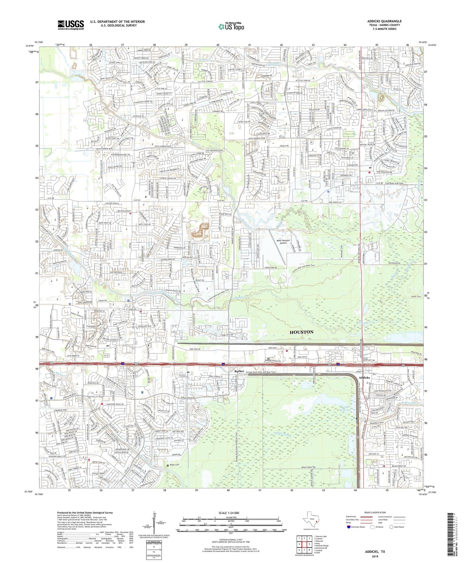
2019 topographic map quadrangle Addicks in the state of Texas. Scale: 1:24000. Based on the newly updated USGS 7.5' US Topo map series, this map is in the following counties: Harris. The map contains contour data, water features, and other items you are used to seeing on USGS maps, but also has updated roads and other features. This is the next generation of topographic maps. Printed on high-quality waterproof paper with UV fade-resistant inks.
Quads adjacent to this one:
West: Katy
Northwest: Warren Lake
North: Cypress
Northeast: Satsuma
East: Hedwig Village
Southeast: Alief
South: Clodine
Southwest: Richmond NE
Contains the following named places: Addicks, Addicks Barker Post Office, Anchor Baptist Church, Autumn Creek Baptist Church Preschool, Autumn Run, Baker Cemetery, Barbara Bush Elementary School, Barker, Barker Post Office, Barker Reservoir, Barkers Landing Office Park Heliport, Bear Creek, Bear Creek Baptist Church, Bear Creek Community Church, Bear Creek Elementary School, Bear Creek Heliport, Bear Creek Park, Bear Creek Plantation, Bear Creek Post Office, Bear Creek Village, Bradford Colony, Briar Hills, Bridgewater Baptist Church, Church of Christ, Church of the Nazarene, Clay Hill Plaza Shopping Center, Concord Colony, Cy - Fair Volunteer Fire Department Station 5, Cy-Fair Volunteer Fire Station 5, Cypress Meadow, Deerfield Village, Dinner Creek, Eckels Heliport, Epiphany of the Lord Catholic Community Church, Faith Community Church, Fleetwood Church of Christ, Fleetwood Post Office, Glen Cairn, Glen Cairn West, Glencairn Park, Green Tree Shopping Center, Harris County Clay Road Courthouse Heliport, Harris County Constable's Office Precinct 5, Harris County Emergency Services Division 48 Fire - EMS Station 3, Harris County Sheriff's Office - Clay Road Substation, Harris County Sheriff's Office - Franz Road Substation, Hazel S Pattison Elementary School, Hearthstone Corners Shopping Center, Horne Elementary School, Houston Covenant Church, Houston Fire Department Station 86, Houston Fire Department Station 90, Houston Heliport, Houston Methodist Continuing Care Hospital, Iglesia Pentecostal Unida Hispana Church, Islamic Society of Greater Houston, James E Taylor High School Baseball Field, James E Taylor High School Basketball Gym, Jamestown Colony, Jean and Betty Schmalz Elementary School, Jeanette Hayes Elementary School, Jowell Elementary School, Katy Church of the Nazarene, Katy Independent School District Police Department, Katy Post Office, Kickerillo Company Heliport, Kingsland Baptist Church, Kingsland Village Shopping Center, Lakes of Bridgewater, Langham Creek, Lieder Elementary School, Loraine T Golbow Elementary School, Mason Park Center Shopping Center, Mason Park West, Maurice L Wolfe Elementary School, Maurice Wolfe Elementary School, Mayde Creek Elementary School, Mayde Creek Farms, Mayde Creek High School, Mayde Creek Junior High School, Mayde Creek Junior High School Baseball Field, Mayde Creek Junior High School Football Field, McRoberts Elementary School, Meadow Walk, Memorial Hermann Rehabilitation Hospital Katy, Memorial Parkway, Memorial Parkway Elementary School, Memorial Thicket, Metcalf Elementary School, Mustang Field, Northglen, Nottingham Country Elementary School, One Mason Plaza Shopping Center, Park Plaza I and II Shopping Center, Parkstone, Parkway Fellowship Church, Parkway Villages, Parkway West, Patterson Elementary School, Peace Community Church, Pine Forest Village, Progressive Baptist Church, Radiant Life Fellowship Church, Robert H Smith Heliport, Rockstone, Rolling Green, Saint Edith Stein Catholic Church, Saint Elizabeth Ann Seton Church, Saint Johns Old South Anglican Catholic Church, Saint Matthias Church, Saint Peters United Methodist Church, Settlers Village, Sheridan Elementary School, Silvermill, Strathmore, Sundown Elementary School, Sundown Glen, T H McDonald Junior High School, Taylor High School, Thornton Junior High School, Trinity Presbyterian Church, Truitt Junior High School, Walker Elementary School, Watkins Junior High School, West Glen, West Harris County Emergency Medical Services Station 3, West Harris County Emergency Medical Services Station 5, West Houston Airport, West Houston Indoor Soccer, West Interstate 10 Fire Department Station 2, West Interstate 10 Fire Department Station 5, West Junction Shopping Center, Westfield, Westfield Free Will Baptist Church, Westfield Village, Westgreen, Westlake, Westlake Forest, Westlake Place, Westlake Village, Westlake Volunteer Fire Department, Westside Church of Christ, Westside Church of the Nazarene, Westside Community Church, Westside High School Baseball Field, Westside High School Football Field and Track, Westside High School Softball Field, Wilson Elementary School - Cypress, Windsong, Windsor Park Lakes, Windstone, Wood Fern, Yorktown Colony, ZIP Codes: 77084, 77094, 77449


