MyTopo
Satsuma Texas US Topo Map
Couldn't load pickup availability
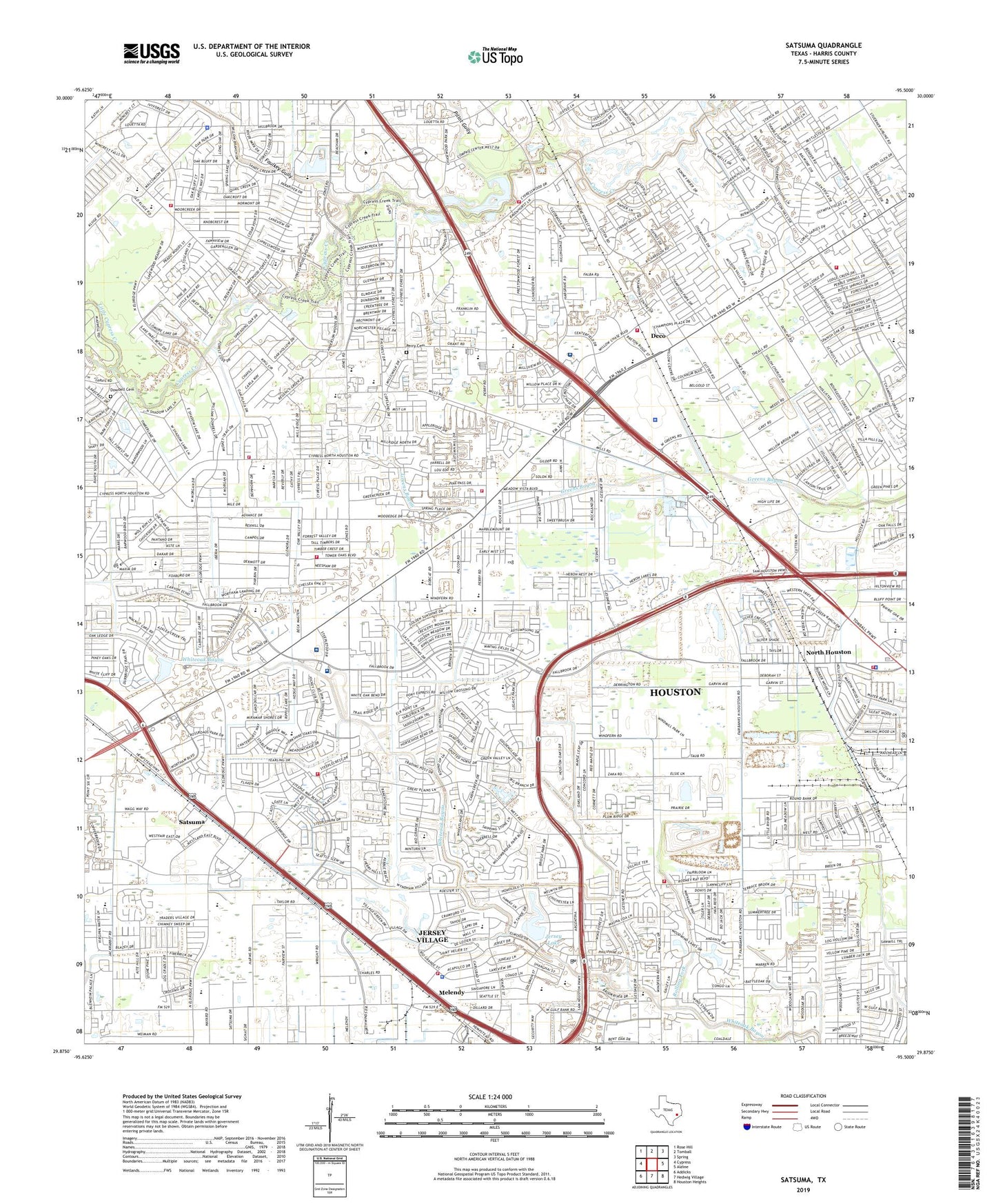
2022 topographic map quadrangle Satsuma in the state of Texas. Scale: 1:24000. Based on the newly updated USGS 7.5' US Topo map series, this map is in the following counties: Harris. The map contains contour data, water features, and other items you are used to seeing on USGS maps, but also has updated roads and other features. This is the next generation of topographic maps. Printed on high-quality waterproof paper with UV fade-resistant inks.
Quads adjacent to this one:
West: Cypress
Northwest: Rose Hill
North: Tomball
Northeast: Spring
East: Aldine
Southeast: Houston Heights
South: Hedwig Village
Southwest: Addicks
This map covers the same area as the classic USGS quad with code o29095h5.
Contains the following named places: Action Number 2 Heliport, Adaptive Behavior Center, Aerodrome Willowbrook, B F Adam Elementary School, Bang Elementary School, Barwood, Baylor Methodist Church, Bell Meads, Bleyl Junior High School, Brookhollow West, Camp Holden, Campbell Junior High School, Canterbury Forest, Cashel Forest, Champion Park, Champions Area Volunteer Fire Department, Champions Covenant Church, Champions East, Champions Forest Plaza Shopping Center, Champions Village I Shopping Center, Chasewood Village Shopping Center, Christ Apostolic Church, Christ the Redeemer Presbyterian Church, Church of Christ - Jersey Village, Church of God of Prophecy, City of Jersey Village, City of Jersey Village Fire Department, Coastal Emergency Medical Service, Cook Junior High School, Creekside Estates South, Cutten Green, Cy - Fair Volunteer Fire Department Station 1, Cy - Fair Volunteer Fire Department Station 10, Cy - Fair Volunteer Fire Department Station 2, Cy Fair Community Church Unity of the Brethren, Cy-Fair Church of the Nazarene, Cy-Fair Surgery Center, Cypress Alternative Learning Center, Cypress Community Christian School Football and Baseball Fields, Cypress Creek Estates, Cypress Creek Fire Department Station 22, Cypress Creek High School, Cypress Creek Volunteer Fire Department Station 21, Cypress Creek Volunteer Fire Department Station 23, Cypress Creek Volunteer Fire Department Station 24, Cypress Fairbanks Medical Center Hospital, Cypress Fairbanks Shopping Center, Cypress Glen, Cypress Plaza, Cypress United Methodist Church, Deco, Dowdell Cemetery, Emmott Elementary School, Epiphany Lutheran Church, Fairbanks Oil Field, Faulkey Gully, Flying Acres Airport, Foundry United Methodist Church, Francone Elementary School, Frazier Elementary School, Gleason Elementary School, Grant Woods Park, Grantwood, Greenwood Forest, Greenwood Forest Elementary School, Hairgrove Elementary School, Hamilton Elementary School, Hamilton Intermediate High School, Harris County Constable's Office Precinct 4 Westside Patrol Substation, Harris County Rural Fire Prevention District Number 20 Fire Station, Harris County Sheriff's Office - Willowood Storefront, Harvest Meadows, Hastings Green, Henry Park, Hickory Hollow Heliport, Hope Community Evangelical Covenant Church, Houston Church of Christ Jesus, Houston Fire Department Station 96, Houston Methodist Willowbrook Hospital, Houston Northwest Baptist Church, Houston Police Department - Willowbrook, Hudson, Huntwick Forest, Jersey Lake, Jersey Village, Jersey Village Baptist Church, Jersey Village City Hall, Jersey Village Fire Department, Jersey Village High School, Jersey Village Police Chief's Office, Jersey Village Police Department, John Wesley United Methodist Church, Jones Square Shopping Center, Kindern Hospital Houston Northwest, Kindred Hospital - Houston Northwest Campus, Kingsmen Lutheran Church, KLAT-AM (Houston), Klenk Elementary School, KPFT-FM (Houston), Lakewood Forest Police Department, Lakewood West, Little Cypress Creek, Long Meadows Country Club, Marshall Dam, Marshall Lake, Matzke Elementary School, Matzke School, Meadowbriar Home, Melendy, Metropolitan Baptist Church, Mill Ridge North, Mills Road Baptist Church, Moore Elementary School, Neuhaus Lake Dam, New Life Pentecostal Church, Norchester, Norchester Shopping Center, North Houston, Northwest Chinese Baptist Church, Northwest Fellowship Church, Northwest Green, Northwest Park, Northwest United Pentecostal Church, Northwest Volunteer Fire Department Station 43, Old Champions Village Shopping Center, Owens Elementary School, Patriot Emergency Medical Services, Pedegrel Forest, Perry Cemetery, Pillot Gully, Post Elementary School, Post School, Pridgeon Stadium, Prince of Peace Catholic Community, Ravensway, Ravensway South, Reed Elementary School, Rolling Fork, Sabacen Park, Saint Boniface Emergency Medical Service, Saint Dunstan Church, Saint Dunstans Episcopal Church, Saint Marys Episcopal Church, Saint Maximilian Kolbe Catholic Community Church, Saint Timothy Lutheran Church, Satsuma, Satsuma Chapel, Shiloh Church, Steeplechase Heliport, Steeplechase Shopping Center, T S Hancock Elementary School, Tallowwood, Texas Department of Public Safety Region 2 Headquarters, Texas Department of Public Safety Texas Rangers Company A, Texas Highway Patrol Office - Houston, The Commons at Willowbrook, Tower Oak Bend, Tower Oak Plaza, Tower Oaks, Tower Oaks Meadows, Turtle Lake, United Methodist Church Lakewood, Westbank, Western Estates, Westway Baptist Church, Willbern Elementary School, Willow Place Post Office, Willowbrook Community Church, Willowbrook Mall Shopping Center, Willowbrook Shopping Center, Willowbrook Sports Complex, Willowchase Shopping Center, Willowood, Winchester Country, Windfern Forest, Windfern High School, Windwood Church, Woodedge Village, Woodland Oaks, Woodland Trails North, Woods of Wimbledon, Wright Grove Baptist Church, Wunderlich Intermediate School, Yeager Elementary School, ZIP Codes: 77064, 77065, 77066, 77069, 77070