MyTopo
Katy Texas US Topo Map
Couldn't load pickup availability
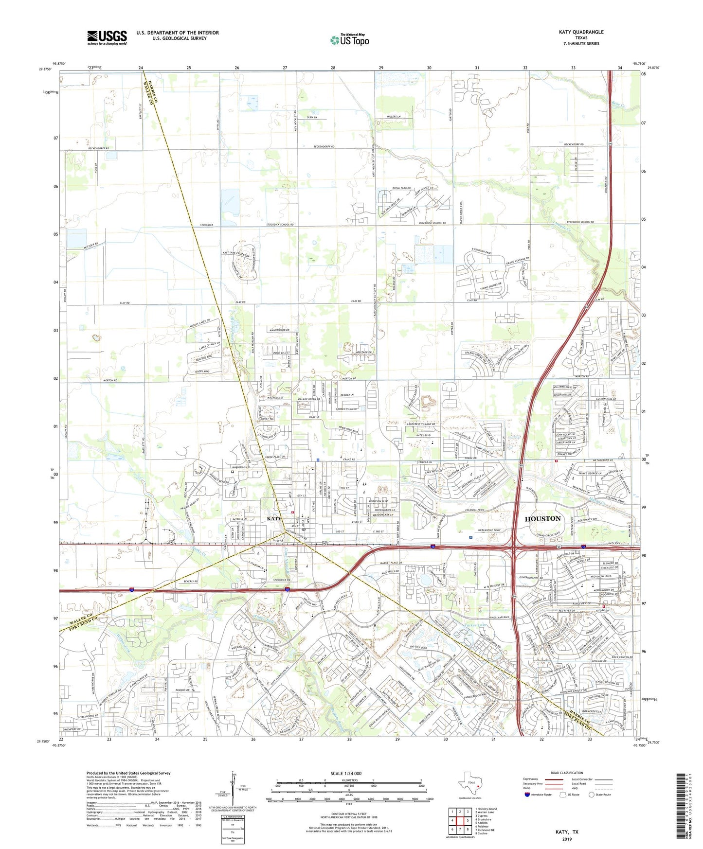
2022 topographic map quadrangle Katy in the state of Texas. Scale: 1:24000. Based on the newly updated USGS 7.5' US Topo map series, this map is in the following counties: Harris, Waller, Fort Bend. The map contains contour data, water features, and other items you are used to seeing on USGS maps, but also has updated roads and other features. This is the next generation of topographic maps. Printed on high-quality waterproof paper with UV fade-resistant inks.
Quads adjacent to this one:
West: Brookshire
Northwest: Hockley Mound
North: Warren Lake
Northeast: Cypress
East: Addicks
Southeast: Clodine
South: Richmond NE
Southwest: Fulshear
This map covers the same area as the classic USGS quad with code o29095g7.
Contains the following named places: Antioch Baptist Church, Arthur R Miller Vocational School and Opportunity Awareness Center, Assembly of God in Katy Church, Cane Island Branch, Christian Center Assembly of God Church, Cimarron, Cimarron Elementary School, Cimmaron Elementary School, Cimmaron South, City of Katy, Cornerstone Evangelical Presbyterian Church, Creekstone Elementary School, Darmar Medical Emergency Heliport, Diane Winborn Elementary School, Doctor James M and Dove Stewart House, Edna Mae Fielder Elementary School, El Shaddai Assembly of God Church, Faith West Academy, Falcon Point, Family Life Assembly of God Church, Fawn Lake, First Baptist Church of Katy, First United Methodist Church Katy, Freeman Property Airport, Good News Baptist Church of Greater Houston, Governor Place, Harris County Fire Department, Heritage Meadows, Hoffpauir Airport, Horn-Katy Hawk International Airport, Jack Rhodes Memorial Stadium, Katy, Katy Branch Library, Katy Chamber of Commerce, Katy City Hall, Katy City Park, Katy Elementary School, Katy Estates, Katy Finance Post Office, Katy Fire Department, Katy Heritage Society, Katy High School, Katy High School Baseball Field, Katy High School Football Stadium, Katy Junior High School, Katy Mills, Katy Mills Mall Shopping Center, Katy Mills Shopping Center, Katy Municipal Complex, Katy Opportunity Awareness Center, Katy Park, Katy Pentecostal Church, Katy Police Department, Katy Senior High School, Katyland, King Air Airport, Krause Education Center, Magnolia Cemetery, Mason Creek Community Church, Mason Creek Village Shopping Center, Mason Road Assembly of God Church, Mason Village Shopping Center, Memorial Hermann Katy Hospital, Memorial Lutheran Center, Memorial Lutheran Church, Memorial Parkway Junior High School, New Vision Baptist Church, Odessa Kilpatric School, Phillipe, Phoenix Emergency Medical Service West, Pin Oak Village, Pine Forest, Pineview Terrace, Redeemer Community Church, Robert King Elementary School, Saint Bartholomew Catholic Church, Saint Pauls Episcopal Church, Snake Creek, Tri-County Baptist Church, Tucker Lake, Tucker Lake Dam, West Harris County Emergency Medical Services Station 1, West Harris County Emergency Medical Services Station 4, West I-10 Volunteer Fire Department, West Interstate 10 Fire Department Station 1, West Interstate 10 Fire Department Station 4, West Memorial Elementary School, West Memorial Junior High School, Whispering Lakes, Williams Chase, Williamsburg Colony, Williamsburg Hamlet, Williamsburg Parish, Williamsburg Parish II, Williamsburg Settlement, Willow Fork, Zelma Hutsell Elementary School, Zelma Hutshell Elementary School, ZIP Code: 77493