MyTopo
Clodine Texas US Topo Map
Couldn't load pickup availability
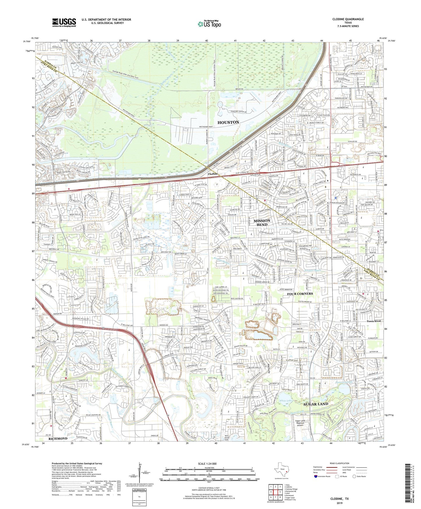
2022 topographic map quadrangle Clodine in the state of Texas. Scale: 1:24000. Based on the newly updated USGS 7.5' US Topo map series, this map is in the following counties: Fort Bend, Harris. The map contains contour data, water features, and other items you are used to seeing on USGS maps, but also has updated roads and other features. This is the next generation of topographic maps. Printed on high-quality waterproof paper with UV fade-resistant inks.
Quads adjacent to this one:
West: Richmond NE
Northwest: Katy
North: Addicks
Northeast: Hedwig Village
East: Alief
Southeast: Missouri City
South: Sugar Land
Southwest: Richmond
This map covers the same area as the classic USGS quad with code o29095f6.
Contains the following named places: Albright Middle School, Alief Church of the Nazarene, Arizona Fleming Elementary School, Austin High School Baseball Field, Austin High School Football Field and Track, Austin High School Softball Field, Barker Dam, Beechnut Village Shopping Center, Chelsea at Mission Bend, Clayton Park, Clodine, Community Volunteer Fire Department Station 1, Community Volunteer Fire Department Station 2, Community Volunteer Fire Department Station 3, Community Volunteer Fire Department Training Center, Dover, Figure Four Lake, First Hispanic Baptist Mission Church, Fish Lake, Flem Rees Elementary School, Forest Wood, Fort Bend Company WCID 1 Harlem Prison Dam, Fort Bend County Alternative School - Fort Bend, Four Corners, Four Corners Census Designated Place, Friendship Church, Gannoway Lake, Garcia Middle School, Grace Assembly Church, Grace United Pentecostal Church, Great Southwest Equestrian Center, Harris County Sheriff's Office - Mission Bend Substation, Hearne Elementary School, Hicks Elementary School, Hidden Lake Estates, Hodges Bend Middle School, Houston Chinese Grace Memorial Church, Joshuas Covenant Church, Kempner High School, Kempner High School Baseball Field, Kempner Stadium, Kerr High School, KEYH-AM (Houston), Kings Landing, Magee Chapel, Manantial Baptist Church, Mason Creek, Mcgee Chapel Baptist Church, Mission Bend, Mission Bend Baptist Church, Mission Bend Census Designated Place, Mission Bend Elementary School, Mission Bend South, Mission Bend United Methodist Church, Mission Glen, Mission Glen Elementary School, Mission Green North, Mission West, Mission West Elementary School, Mount Pleasant Baptist Church, Northeast Fort Bend County Fire Department Station 1, Oak Park Trails, Oakhill Missionary Baptist Church, O'Donnell Middle School, Oyster Creek Elementary School, Park Ridge, Parkhollow Place, Pecan Grove, Pecan Grove Elementary School, Petrosky Elementary School, Pheasant Creek, Pilgrims Frontier Fellowship Church, Pleasant Green Church, Presidio Square Shopping Center, Providence, Providence Baptist Church, Ragus Lake Estates, Randalls Shopping Center at Mission Bend, Red Gully, Saint Theresa Church, Saint Theresa School, San Miguel, Sardar Patel Stadium, Shiloh Church, Shiloh Lake Estates, Southwest Calvary Baptist Church Spanish Ministry, Stratford Park, Sugar Land Church of Christ, Sugar Land Middle School, Sugar Land Regional Airport, Sugar Mill Elementary School, Sugar Mill Park, Summerfield, The Commons at Presidio Square Shopping Center, Town West, University of Houston West Houston Institute, Village at West Oaks, Village of Oak Lakes, Waterford, West Hollow Park, West Oaks Baptist Church, West Oaks Central Shopping Center, West Oaks Fellowship Church, West Oaks Shopping Center, West Oaks Village, West Oaks Village Shopping Center, West Wind, Westheimer Oaks Shopping Center, White Lake, ZIP Codes: 77082, 77083, 77407, 77450, 77498