MyTopo
Amarillo West Texas US Topo Map
Couldn't load pickup availability
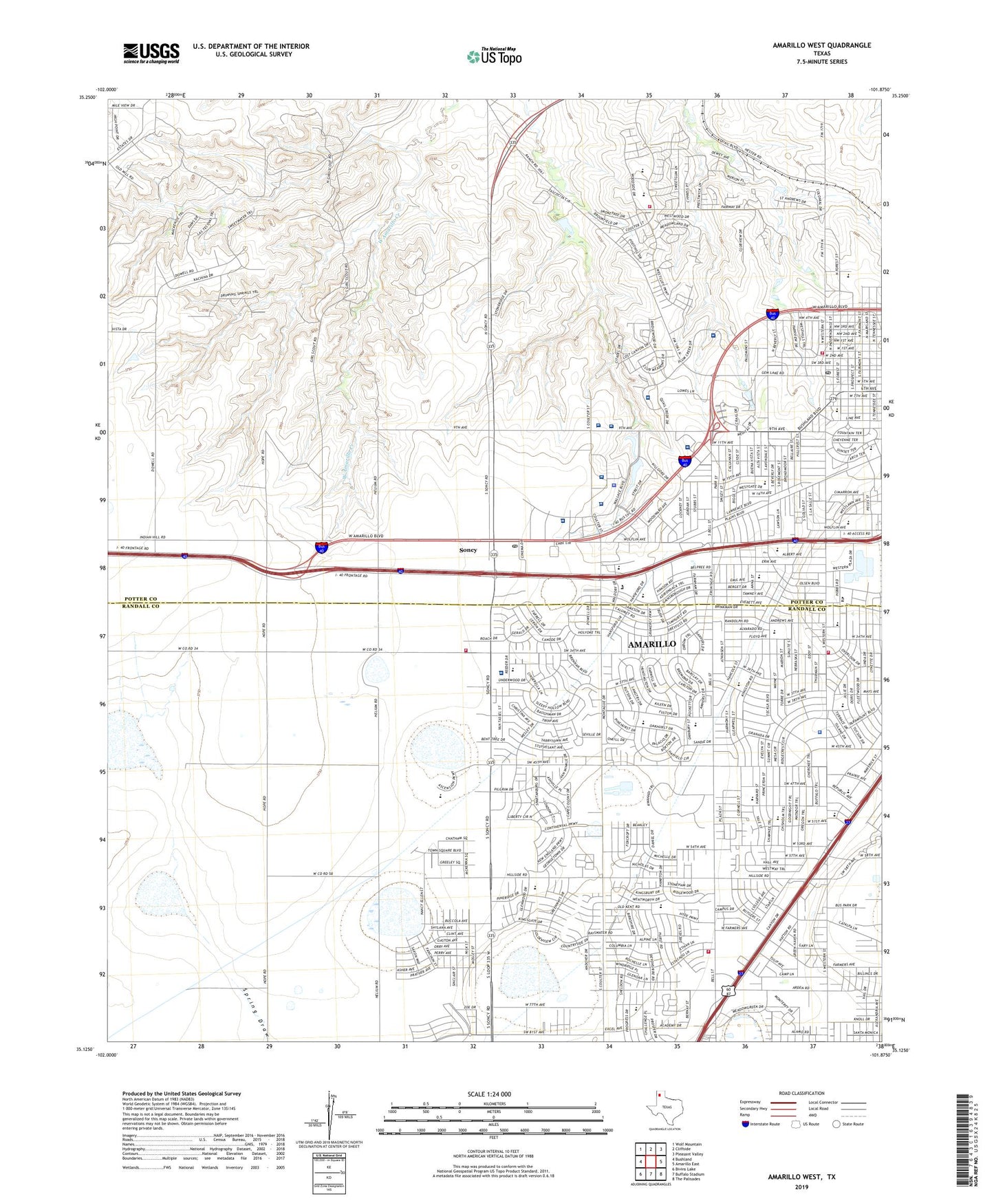
2023 topographic map quadrangle Amarillo West in the state of Texas. Scale: 1:24000. Based on the newly updated USGS 7.5' US Topo map series, this map is in the following counties: Potter, Randall. The map contains contour data, water features, and other items you are used to seeing on USGS maps, but also has updated roads and other features. This is the next generation of topographic maps. Printed on high-quality waterproof paper with UV fade-resistant inks.
Quads adjacent to this one:
West: Bushland
Northwest: Wolf Mountain
North: Cliffside
Northeast: Pleasant Valley
East: Amarillo East
Southeast: The Palisades
South: Buffalo Stadium
Southwest: Bivins Lake
This map covers the same area as the classic USGS quad with code o35101b8.
Contains the following named places: Amarillo Area Center for Advanced Learning, Amarillo Country Club, Amarillo Dillas Pro Baseball Field, Amarillo Fire Department Station 11, Amarillo Fire Department Station 2, Amarillo Fire Department Station 3, Amarillo Fire Department Station 8, Amarillo Fire Department Station 9, Amarillo Post Office San Jacinto Station, Arden Road Elementary School, Austin Middle School, Avondale Elementary School, Avondale School, Baptist Saint Anthonys Hospital, Bell Avenue Baptist Church, Bell Avenue Church of Christ, Belmar Elementary School, Bonham Middle School, Christ Community Church, Christ Covenant Presbyterian Church, Christ Lutheran Church, Christian Church of God, Church of Christ Anna Street, Church of Christ Olsen Park, Coulter Road Baptist Church, Crockett Middle School, David Crockett Junior High School, Don Harrington Discovery Center, First Temple Assembly of God Church, Freedom Baptist Church, High Plains Baptist Church, Highland Baptist Church, Homebound School - Amarillo, Houston Middle School, Jordan Post Office, Kindred Hospital Amarillo, Kiwanis Camp, KLMN-FM (Amarillo), KMML-FM (Amarillo), KZIP-AM (Amarillo), LIFESTAR Ambulance, Lone Star Post Office, Northwest Texas Hospital, Northwest Texas Surgery Center, O'Hara Flying Service II, Olsen Park Elementary School, Olsen Park School, Olsen Park Seventh Day Adventist Church, Panhandle Surgical Hospital, Paramount Baptist Deaf Church, Paramount Park, Paramount Terrace Elementary School, Paramount Terrace School, Plum Creek Specialty Hospital, Potter County Constables Office Precinct 3, Prince of Peace Lutheran Church, Puckett Elementary School, Quail Creek Surgical Hospital, Randall County Sheriff's Office - Annex Station, Ridgecrest Elementary School, Saint John Greek Orthodox Church, Saint Peters Episcopal Church, Sam Houston Junior High School, Sam Houston Park, San Jacinto Baptist Church, Sleepy Hollow Elementary School, Soncy, Southwest Church of Christ, Southwest Park, Tascosa Country Club, Tascosa High School, Texas Tech University Police Department - Amarillo Campus, Thomas E Creek Veterans Affairs Medical Center, Valleyview Church of the Nazarene, Vibra Rehabilitation Hospital of Amarillo, West Hill Park, West Lawn Park, Western Plateau Elementary School, Western Plaza Shopping Center, Westgate Shopping Center, Wills Elementary School, Wills School, Windsor Elementary School, ZIP Codes: 79106, 79109, 79110, 79121