MyTopo
Brownwood Texas US Topo Map
Couldn't load pickup availability
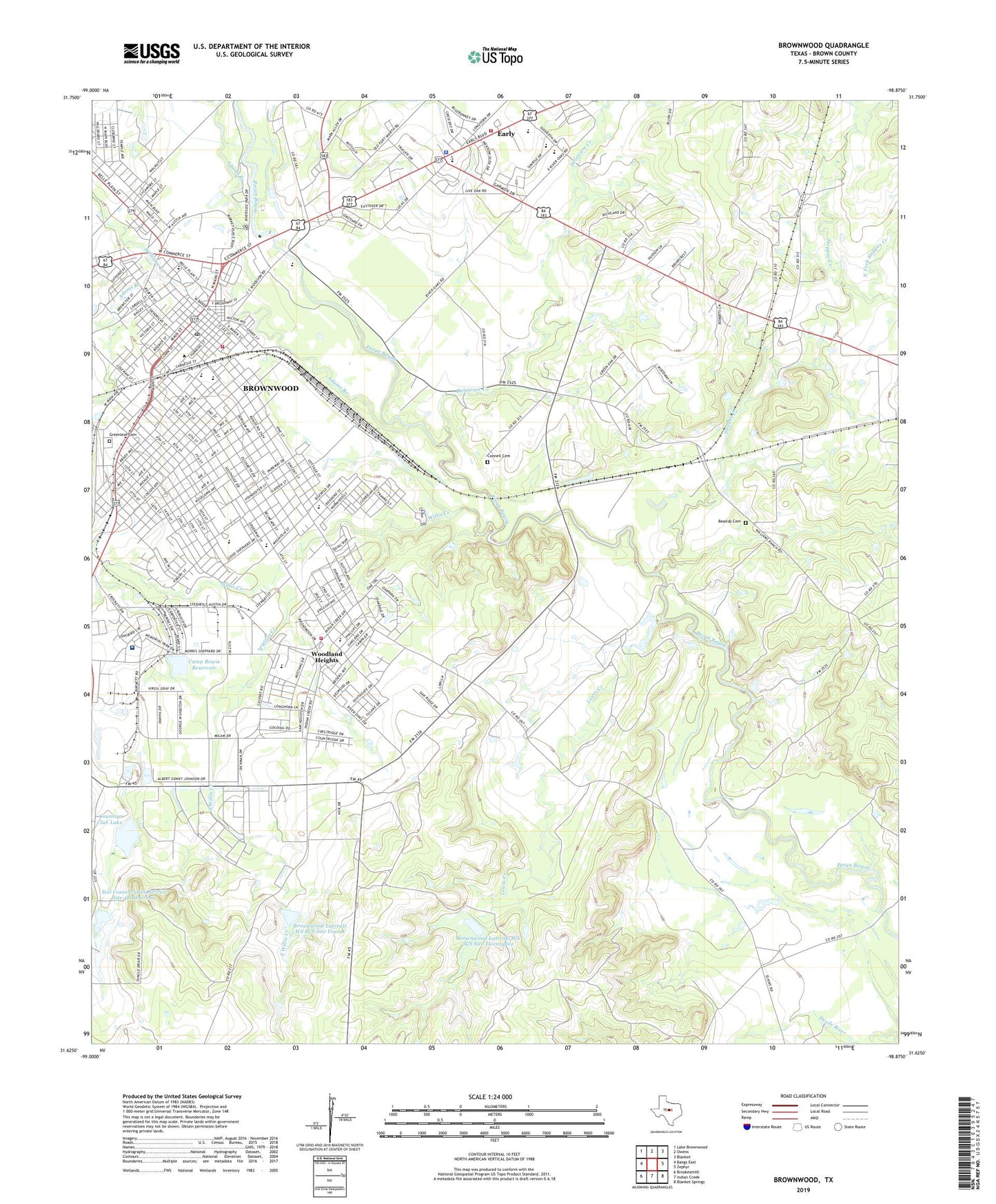
2019 topographic map quadrangle Brownwood in the state of Texas. Scale: 1:24000. Based on the newly updated USGS 7.5' US Topo map series, this map is in the following counties: Brown. The map contains contour data, water features, and other items you are used to seeing on USGS maps, but also has updated roads and other features. This is the next generation of topographic maps. Printed on high-quality waterproof paper with UV fade-resistant inks.
Quads adjacent to this one:
West: Bangs East
Northwest: Lake Brownwood
North: Owens
Northeast: Blanket
East: Zephyr
Southeast: Blanket Springs
South: Indian Creek
Southwest: Brookesmith
Contains the following named places: 36th Division Memorial Park, 76802, Adair Spring Park, Adams Branch, Air Evac Lifeteam Brownwood Base, Allcorn Park, Baptist Church, Beairds Cemetery, Brown County Court House, Brown County Jail, Brownwood, Brownwood City Hall, Brownwood City Park, Brownwood Fire Department Station 1, Brownwood Fire Department Station 2, Brownwood Intermediate School, Brownwood Junior High School, Brownwood Lateral Watershed Number 4-B, Brownwood Laterals WS SCS Site Four A, Brownwood Laterals WS SCS Site Twentyfive, Brownwood Middle School, Brownwood Post Office, Brownwood Senior High School, Brownwoods Kindergarden, Bunnin Park, Camp Bowie Memorial Air Park, Camp Bowie Park, Camp Bowie Reservoir, Central Baptist Church, Central United Methodist Church, Christ Chapel Church, Church of Christ, City of Brownwood, City of Early, Clark Park, Coggin Elementary School, Coggin Park, Connell Cemetery, Cordell Park, Country Club Dam, Country Club Lake, Delaware Creek, Douglas MacArthur Academy of Freedom Museum, Douglas MacArthur Academy of Freedom School, Early, Early City Hall, Early City Park, Early Elementary School, Early Fire Department, Early Police Department, Early Post Office, Early Primary School, Early Schools, East Fork Steppes Creek, Faith Baptist Church, Fellowship Baptist Church, First Baptist Church, First Church of the Nazarene, First Mexican Baptist Church, Gordon Wood Stadium, Greater Faith Community Church, Greenleaf Cemetery, Guardian Emergency Medical Services, Heart of Texas Baptist Area Church, Hendrick Medical Center Brownwood, Howard Payne University, J A Walker House and R B Rogers House, KBWD-AM (Brownwood), Kiwanis Park, KXYL-AM (Brownwood), Lewis Creek, Little Zion Baptist Church, Longhron Stadium, Mayes Park, McDonald Field, Milton Avenue Baptist Church, Municipal Reservoir, Municipal Reservoir Upper Dam, North Fork Steppes Creek, Red Stone Park, Ricker, River of Life Community Church, Riverside Park, Saint Johns Episcopal Church, Seventh Day Adventist Church, Sharp Park, Soil Conservation Service Site 25 Dam, Soil Conservation Service Site 4a Dam, Soil Conservation Service Site 4b Dam, Soil Conservation Service Site 4b Reservoir, South Elementary School, South Willis Creek, Southside Assembly of God Church, Southside Baptist Church, Sportsman Park, Steppes Creek, Stonegate Park, Tenmile Crossing, Texas Department of Criminal Justice Thomas R Havins Unit, Texas Parks and Wildlife Department Law Enforcement Division, Thomason Park, US Agricultural Experiment, Victory Baptist Church, Vincent Street Park, Wiggins Park, Williams Creek, Willis Creek, Woodcreek Baptist Church, Woodland Heights, Woodland Heights Elementary School