MyTopo
Canutillo Texas US Topo Map
Couldn't load pickup availability
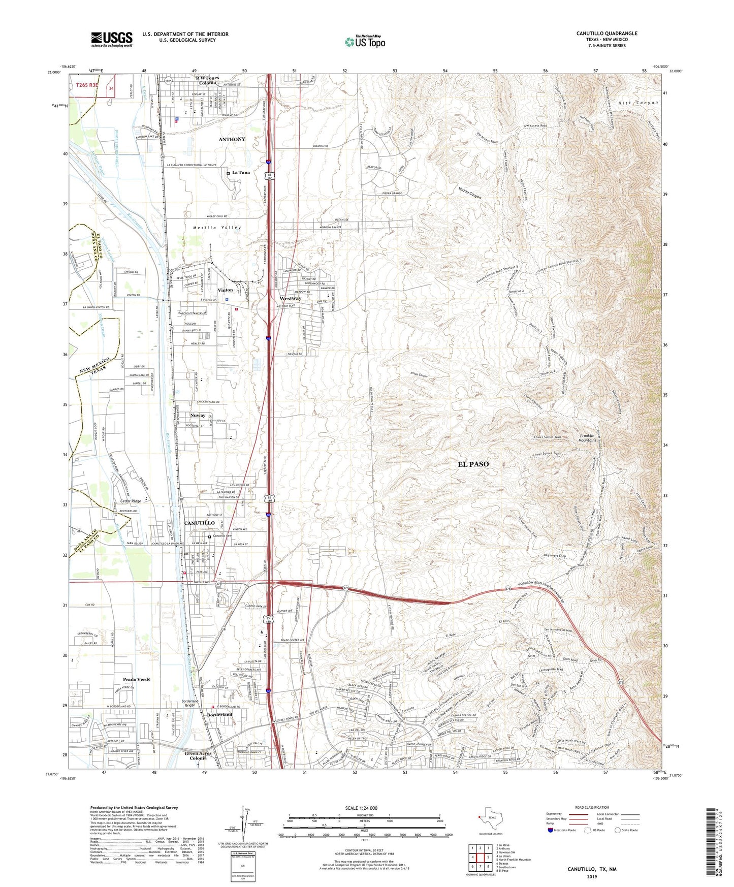
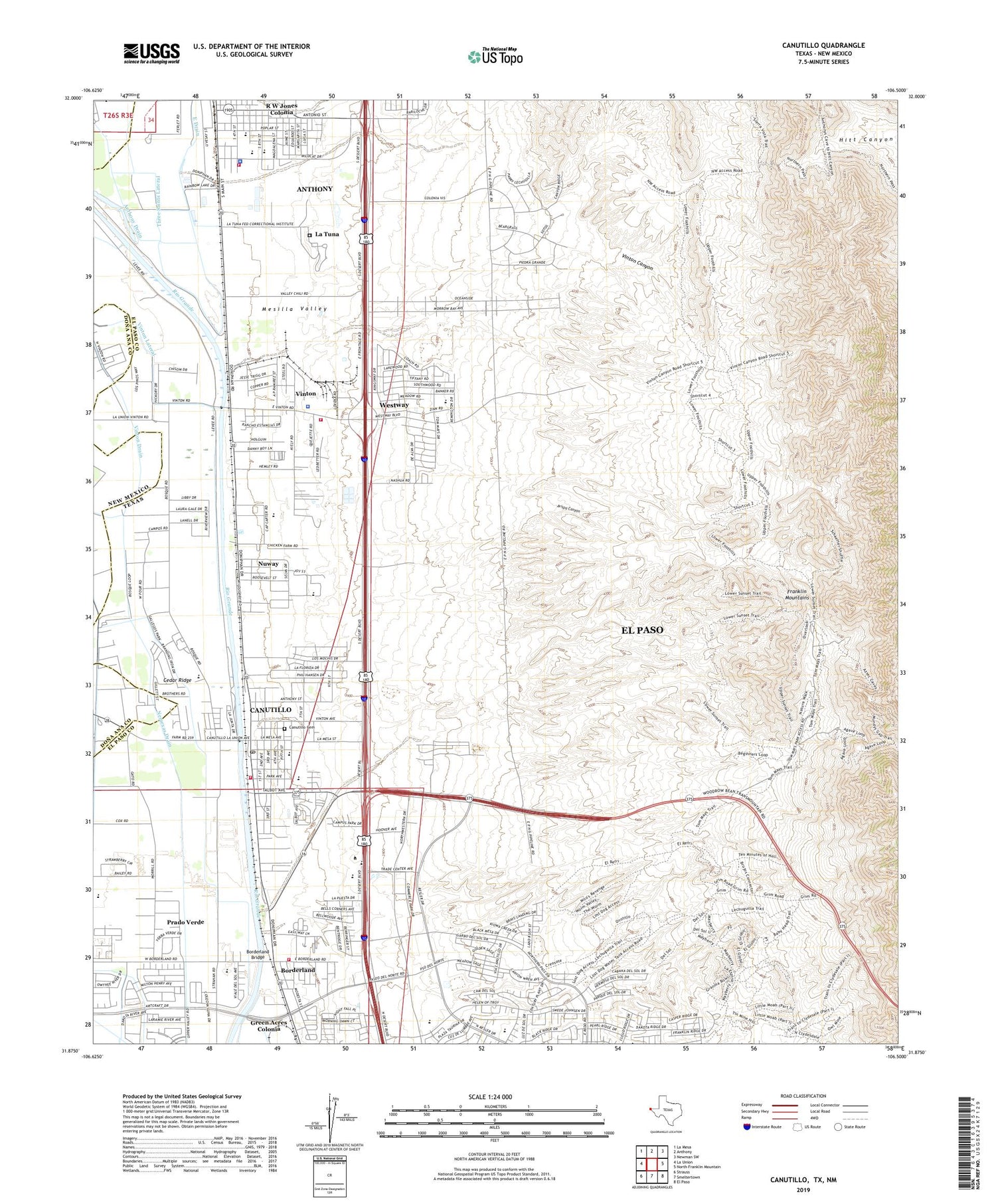
2019 topographic map quadrangle Canutillo in the states of Texas, New Mexico. Scale: 1:24000. Based on the newly updated USGS 7.5' US Topo map series, this map is in the following counties: El Paso, Doña Ana. The map contains contour data, water features, and other items you are used to seeing on USGS maps, but also has updated roads and other features. This is the next generation of topographic maps. Printed on high-quality waterproof paper with UV fade-resistant inks.
Quads adjacent to this one:
West: La Union
Northwest: La Mesa
North: Anthony
Northeast: Newman SW
East: North Franklin Mountain
Southeast: El Paso
South: Smeltertown
Southwest: Strauss
Contains the following named places: Anthony, Anthony Drain, Anthony Elementary School, Anthony Police Department, Anthony Town Hall, Avispa Canyon, Bill Childress Elementary School, Borderland, Borderland Bridge, Borderland Spur, Canutillo, Canutillo Alternative School, Canutillo Cemetery, Canutillo Census Designated Place, Canutillo High School, Canutillo Middle School, Canutillo Post Office, Canutillo Primary School, Cedar Ridge, City 301 Water Well, East Drain, El Paso County Constable's Office Precinct 7, El Paso County Sheriff's Office - Vinton Patrol Station, El Paso Fire Department Station 2, El Paso Northwest Division, Federal Correctional Institution La Tuna, First Baptist Church of Canutillo, Franklin Mountains State Natural Area, Franklin Mountains State Park Trail Network, Gallegos Park, Green Acres Colonia, Hermosa Vista Addition Colonia, Irnie Ranson Park, La Tuna, La Union East Lateral, La Union Estates Colonia, Life Ambulance Service Station 1, Mobile Haven Estates Colonia, Mount Zion Church, Nemexas Drain, NM 4904449 Water Well, Nuway, Nuway Addition Colonia, Polkinghorn Addition Colonia, Ponderosa Mobile Home Colonia, Prado Verde, Prado Verde Addition Number 1 Colonia, Prado Verde Census Designated Place, Q-63 Water Well, R W Jones Colonia, Resler Drive Walk and Bike Trail, Schuman Estates Colonia, Serene Acres Colonia, Three Saints Lateral, Tom Mays Unit Trail, Town of Anthony, United States Bureau of Reclamation 49 Water Well, United States Bureau of Reclamation 50 Water Well, Village of Vinton, Vinton, Vinton Acres Number 1 Colonia, Vinton Canyon, Vinton Drain, Vinton Lateral, Vinton River Drain, West Valley Fire Department Anthony Station, West Valley Fire Department Canutillo Station, West Valley Fire Department Vinton Station, Westside Baptist Temple Church, Westway, Westway Census Designated Place, Westway Number 1 Colonia, Westway Number 2 Colonia, Westway Number 3 Colonia, Westway Number 4 Colonia, Westway Number 6 Colonia, Westway Number 7 Colonia, ZIP Codes: 79821, 79835, 79911