MyTopo
North Franklin Mountain Texas US Topo Map
Couldn't load pickup availability
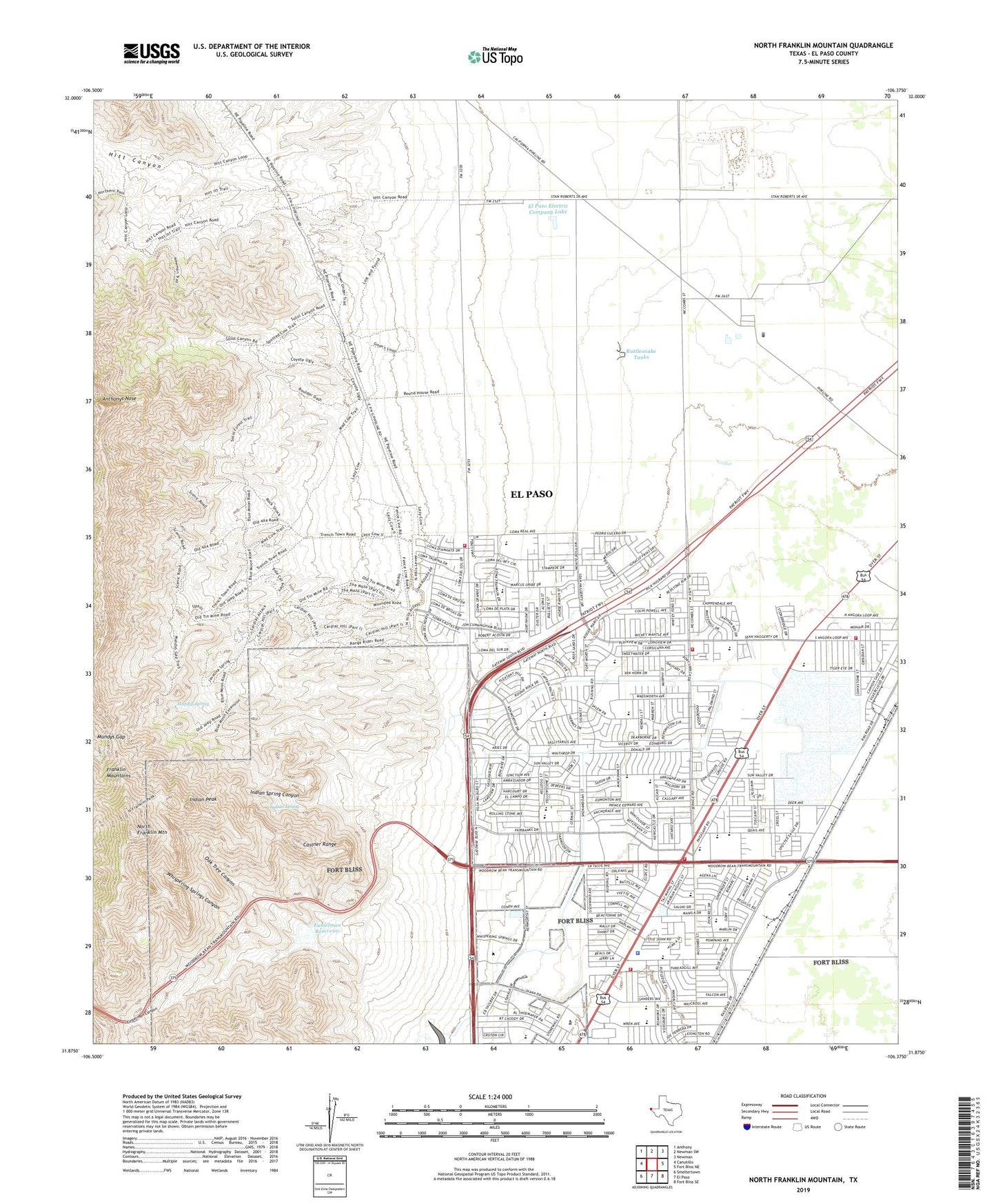
2022 topographic map quadrangle North Franklin Mountain in the state of Texas. Scale: 1:24000. Based on the newly updated USGS 7.5' US Topo map series, this map is in the following counties: El Paso. The map contains contour data, water features, and other items you are used to seeing on USGS maps, but also has updated roads and other features. This is the next generation of topographic maps. Printed on high-quality waterproof paper with UV fade-resistant inks.
Quads adjacent to this one:
West: Canutillo
Northwest: Anthony
North: Newman SW
Northeast: Newman
East: Fort Bliss NE
Southeast: Fort Bliss SE
South: El Paso
Southwest: Smeltertown
This map covers the same area as the classic USGS quad with code o31106h4.
Contains the following named places: Andress High School, Andress High School Stadium, Anthonys Nose, Apollo Heights Baptist Chapel Church, Arlington Park, Border Patrol Museum, Bradley Elementary School, Castner Range, Charles Middle School, Christ the Savior Catholic Church, Civic Leaders Park, Cohen Stadium, Collins Elementary School, Colonia Verde Park, Crosby Elementary School, Desertaire Elementary School, Dolphin Park, Dolphin Terrace Elementary School, Dowell Elementary School, El Paso Church of God Northeast, El Paso County Constable's Office Precinct 2, El Paso Electric Company Lake, El Paso Electric Company Lake Dam, El Paso Fire Department Station 21, El Paso Fire Department Station 23, El Paso Fire Department Station 28, El Paso Fire Department Station 30, El Paso Fire Department Station 34, El Paso Korean Baptist Church, El Paso Korean United Methodist Church, El Paso Police Department - Northeast Regional Command, El Paso Young NAK Presbyterian Church, Fannin Elementary School, First United Baptist Church, Franklin Mountains, Fusselman Canyon, Fusselman Dam, Fusselman Reservoir, Hitt Canyon, Hitt Ranch, Iglesia Apostolica de Northeast Church, Indian Peak, Indian Spring, Indian Spring Canyon, Irvin High School, J M Whitaker Elementary School, KROD-AM (El Paso), McCombs Baptist Church, Milagro Park, Mission Apostolic Church, Mount Zion Baptist Church, Mundys Gap, Mundys Spring, New Beginning Missionary Baptist Church, New Hope Pentecostal Church, New Well, Newman Elementary School, North Franklin Mountain, Northeast Seventh Day Adventist Church, Northgate Baptist Church, Northgate El Paso Post Office, NorthPark Shopping Center, Oak Tree Canyon, Open Gate Church of the Nazarene, Parkland Elementary School, Parkland High School, Parkland Middle School, Range Dam, Range Reservoir, Rattlesnake Tanks, Recreation Ranch Park, Saint Johns Lutheran Church, Schuster Elementary School, Shearman Park, Skyline Baptist Church, Skyline Optimist Youth Park, Smugglers Pass, South Well, Student Memorial Park, Sun Valley Baptist Church, Terrace Hills Middle School, That Marvelous Light Baptist Church, Tobin Park United Methodist Church, Veterans Park, West Well, Western District United Methodist Church, Whispering Springs Canyon, Wilderness Park Museum, Wilderness Park Museum Trail, ZIP Codes: 79924, 79934