MyTopo
Colleyville Texas US Topo Map
Couldn't load pickup availability
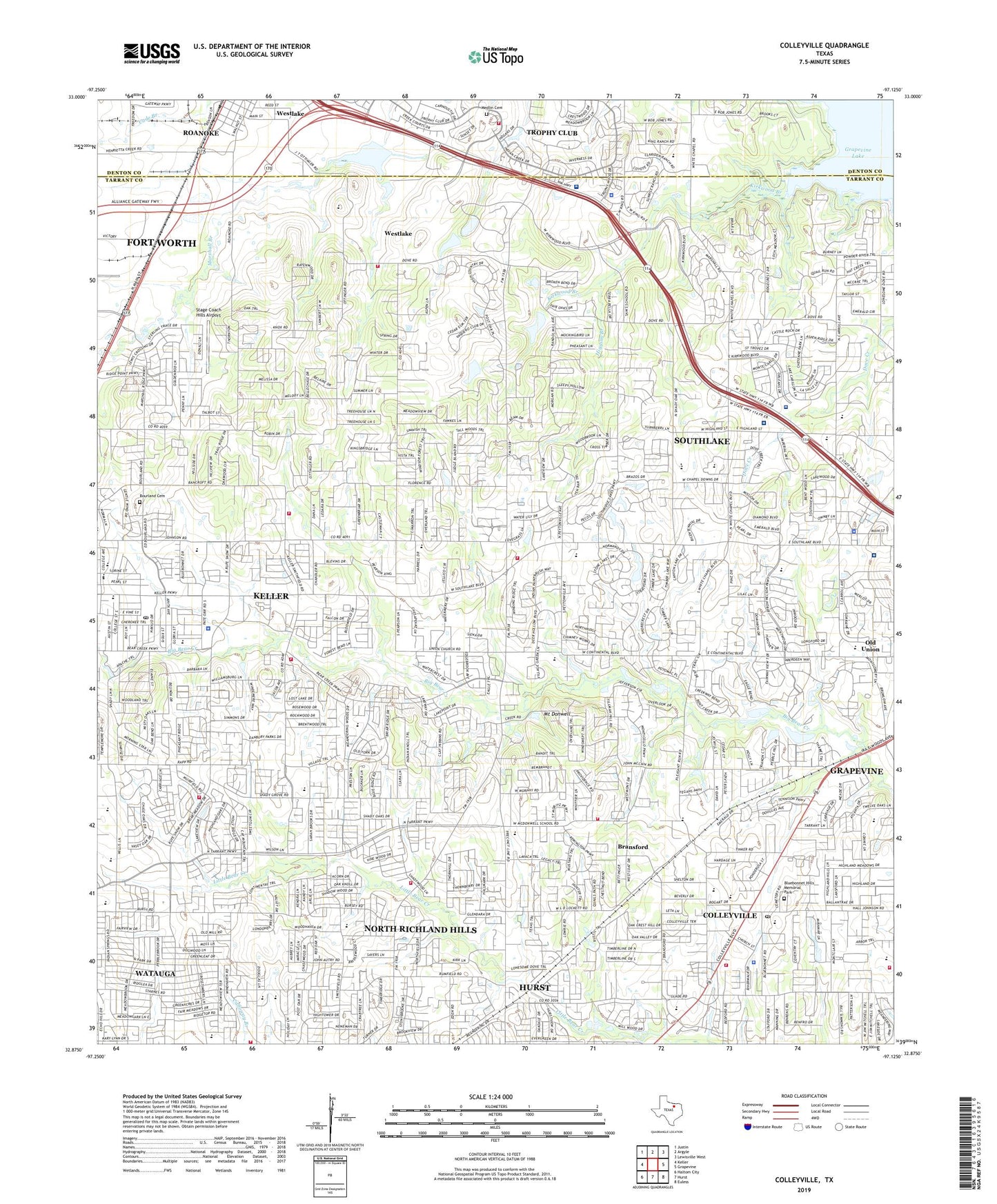
2022 topographic map quadrangle Colleyville in the state of Texas. Scale: 1:24000. Based on the newly updated USGS 7.5' US Topo map series, this map is in the following counties: Tarrant, Denton. The map contains contour data, water features, and other items you are used to seeing on USGS maps, but also has updated roads and other features. This is the next generation of topographic maps. Printed on high-quality waterproof paper with UV fade-resistant inks.
Quads adjacent to this one:
West: Keller
Northwest: Justin
North: Argyle
Northeast: Lewisville West
East: Grapevine
Southeast: Euless
South: Hurst
Southwest: Haltom City
This map covers the same area as the classic USGS quad with code o32097h2.
Contains the following named places: Baylor Scott and White Medical Center Trophy Club, Bear Creek Intermediate School, Bluebonnet Hills Memorial Park, Bourland Cemetery, Bransford, Bransford Elementary School, Camp Burnett, Carroll Elementary School, Carroll High School, Carroll Intermediate School, Carroll Middle School, Carroll Middle School Football Field and Track, Carroll Road Church, Church of God, City of Colleyville, City of Keller, City of Southlake, Colleyville, Colleyville Church of Christ, Colleyville City Hall, Colleyville City Park, Colleyville Elementary School, Colleyville Fire Department Station 1, Colleyville Fire Department Station 3, Colleyville Middle School, Colleyville Police Department, Colleyville Post Office, Craig Airport, Cross Timber Middle School, Don T Durham Elementary School, Don T Durham Intermediate School, First Baptist Church of Roanoke, First Baptist Church of Trophy Club, First United Methodist Church Colleyville, First United Methodist Church of Keller, Florence Elementary School, Flying Cap Valley Airport, Forest Village Park, Foster Village Elementary School, Glenhope Elementary School, Good Shepherd Catholic Community Church, Goode Airport, Green Valley Elementary School, Higgins Branch, Hillsboro City Library, Jack D Johnson Elementary School, Keller - Harvel Elementary School, Keller Fire and Rescue Station 2, Keller Fire and Rescue Station 3, Keller High School, Keller Independent School District Athletic Complex, Keller Middle School, Keller Police Department, Keller Post Office, Keller Town Hall, Kirkwood Branch, KMS Stadium, L D Lockett Park, Lakeside Presbyterian Church, Lazy K Acres Airport, Lonesome Dove Church, Medlin Cemetery, Mount Donwell, Mount Gilead Church, New Direction Learning Center, North Richland Hills Fire Department Station 1, North Richland Hills Fire Department Station 4, North Ridge Elementary School, North Ridge Middle School, Northeast Tarrant Division, Northfield Park, Old Continental State Bank, Old Union, Pleasant Run Baptist Church, Pleasant Run School, Roanoke City Hall, Robert H Rockenbaugh Elementary School, Shady Grove Church, Shady Grove Elementary School, Southlake, Southlake Assembly of God Church, Southlake City Hall, Southlake Department of Public Safety West Station 2, Southlake Fire Department Station 401, Southlake Police Department, Southlake Post Office, Southlake Town Square Shopping Center, Stage Coach Hills Airport, Taylor Elementary School, Texas Health Harris Methodist Hospital Southlake, Town of Trophy Club, Town of Westlake, Trophy Club, Trophy Club Fire Department, Trophy Club Police Department, Turner Lake, Turner Lake Dam, Walnut Grove Park, Walnut Grove Trail, Westlake, Westlake Department of Public Safety, Westlake Town Hall, Whites Chapel United Methodist Church, Willis Lane Elementary School, ZIP Codes: 76034, 76092, 76182, 76248