MyTopo
Grapevine Texas US Topo Map
Couldn't load pickup availability
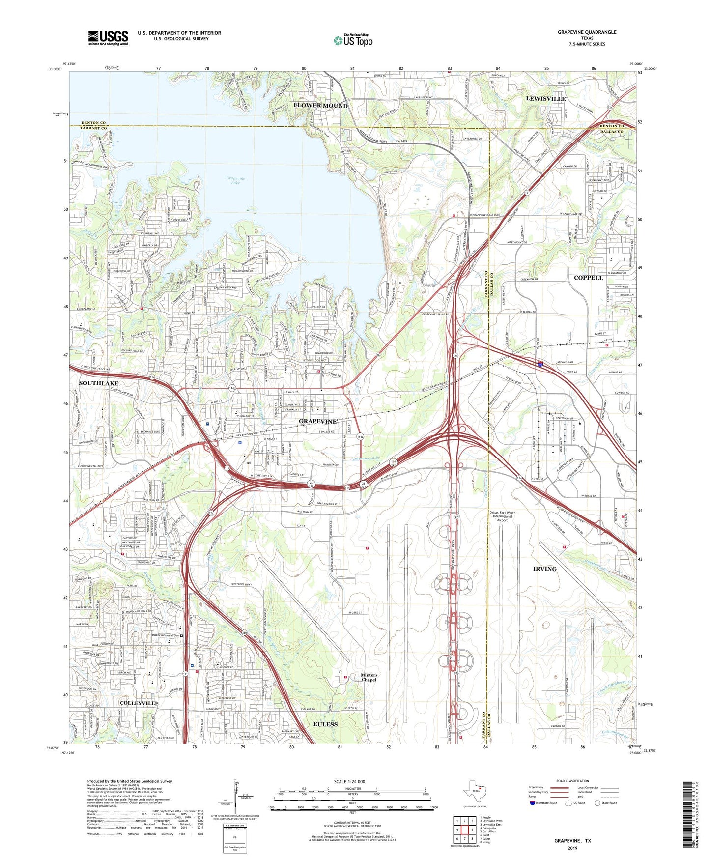
2022 topographic map quadrangle Grapevine in the state of Texas. Scale: 1:24000. Based on the newly updated USGS 7.5' US Topo map series, this map is in the following counties: Tarrant, Dallas, Denton. The map contains contour data, water features, and other items you are used to seeing on USGS maps, but also has updated roads and other features. This is the next generation of topographic maps. Printed on high-quality waterproof paper with UV fade-resistant inks.
Quads adjacent to this one:
West: Colleyville
Northwest: Argyle
North: Lewisville West
Northeast: Lewisville East
East: Carrollton
Southeast: Irving
South: Euless
Southwest: Hurst
This map covers the same area as the classic USGS quad with code o32097h1.
Contains the following named places: Abundant Life Assembly of God Church, Andrew Brown Community Park, Bakers Branch, Banyan Park, Baylor Scott and White Medical Center - Grapevine, Bear Run Park, Bethel Baptist Church, Cable Branch, Cannon Elementary School, Carroll Middle School, Christ Fellowship Church, Church of God, City of Grapevine, Cluck Park, Colleyville Heritage High School, Coppell, Coppell Fire Department Station 1, Coppell Middle School West, Cotton Belt Railroad Industrial Historic District, Cottonwood Creek Elementary School, Cowboy Stadium, Dallas Fort Worth Airport Department of Public Safety Ambulance, Dallas Fort Worth International Airport Department of Public Safety Fire Station 4, Dallas Fort Worth International Airport Department of Public Safety Station 2, Dallas Fort Worth International Airport Department of Public Safety Station 3, Dallas Fort Worth International Airport Department of Public Safety Station 5, Dallas-Fort Worth International Airport, Dove Creek, Dove Elementary School, Dove Park, Dragon Stadium, Faith Christian School Football Field, Farris Branch, First Presbyterian Church in Grapevine, Flower Mound Fire Department Station 5, Flower Mound Water Treatment Facility, Grapevine, Grapevine Baptist Church, Grapevine Church of Christ, Grapevine City Hall, Grapevine Commercial Historic District, Grapevine Dam, Grapevine Elementary School, Grapevine Fire Department Station 1, Grapevine Fire Department Station 2, Grapevine Fire Department Station 3, Grapevine Fire Department Station 4, Grapevine Fire Department Station 5, Grapevine High School, Grapevine Historic Museum, Grapevine Lake, Grapevine Middle School, Grapevine Mills, Grapevine Mills Mall Shopping Center, Grapevine Original Town Residential Historic District, Grapevine Police Department, Grapevine Post Office, Grapevine Recreational Area, H S Jackson Sand and Gravel Dam Number 1, Heritage Elementary School, Heritage Middle School, Heritage Park, Hudgens Branch, Irving Fire Department Station 9, Jackson Sand and Gravel Reservoir 1 Dam, Jones Branch, Lake Number 1, Lake View Park, Love Chapel Church of God in Christ, Meadowmere Park, Memorial Baptist Church, Minters Chapel, Morehead Branch, Mount Horum Baptist Church, Mustang-Panther Stadium, Northshore Trail, Northwest Crossing Shopping Center, Oak Grove Park, Park Wood Park, Parker Memorial Cemetery, Parr Park, Peach Street Wastewater Treatment Plant, Pecan Park, Pickering Park, Pleasant Glade Baptist Church, Reservoir Number 1, Rockledge Park, Sagecrest Hospital Grapevine, Saint Francis Catholic Church, Saint Laurence Episcopal Church, Silver Lake Branch, Silver Lake Elementary School, Silver Lake Park, Sonset Fellowship Church, The Bridges Academy, The Church of Jesus Christ of Latter Day Saints, Timberline Elementary School, Walnut Grove Trail, Wilson Elementary School, Yorkshire Meadows Park, ZIP Code: 76051