MyTopo
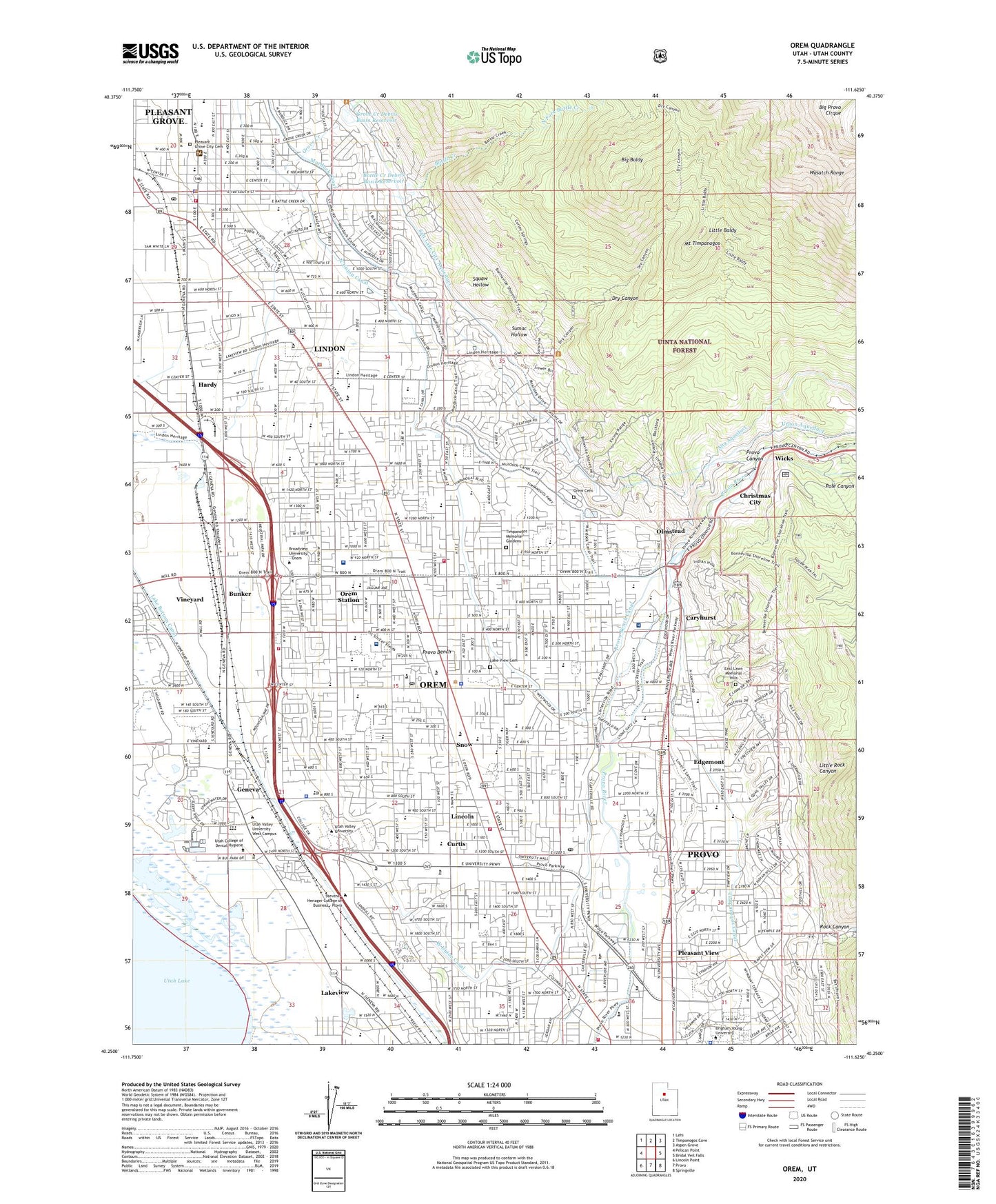
Orem Utah US Topo Map
Couldn't load pickup availability
Also explore the Orem Forest Service Topo of this same quad for updated USFS data
2023 topographic map quadrangle Orem in the state of Utah. Scale: 1:24000. Based on the newly updated USGS 7.5' US Topo map series, this map is in the following counties: Utah. The map contains contour data, water features, and other items you are used to seeing on USGS maps, but also has updated roads and other features. This is the next generation of topographic maps. Printed on high-quality waterproof paper with UV fade-resistant inks.
Quads adjacent to this one:
West: Pelican Point
Northwest: Lehi
North: Timpanogos Cave
Northeast: Aspen Grove
East: Bridal Veil Falls
Southeast: Springville
South: Provo
Southwest: Lincoln Point
This map covers the same area as the classic USGS quad with code o40111c6.
Contains the following named places: Alta Aqueduct, Aspen Elementary School, Battle Creek, Battle Creek Debris Basin Dam, Battle Creek Debris Basin Reservoir, Battle Creek Fort, Big Baldy, Bonneville Elementary School, Brigham Young University, Brigham Young University Police Department, Bunker, Canyon Crest Elementary School, Canyon View Junior High School, Caryhurst, Cascade Elementary School, Charter Canyon Hospital, Cherry Hill Elementary School, Christmas City, City of Lindon, City of Orem, City of Pleasant Grove, Cougar Stadium, Curtis, Dry Canyon, East Lawn Memorial Hills, Edgemont, Evangelical Free Church, First Baptist Church, Geneva, Geneva Elementary School, Geneva Steel Plant, Grace Baptist Church, Grandview School, Grove Creek, Grove Creek Debris Basin Dam, Grove Creek Debris Basin Reservoir, Grovecrest Elementary School, Hardy, Hellspot Tower, Hillcrest Elementary School, Indian Trail, KABE-FM (Orem), KOHS-FM (Orem), KPGR-FM (Pleasant Grove), Lake Bottom Canal, Lake View Cemetery, Lakeridge Junior High School, Lakeview, Lincoln, Lincoln High School, Lindon, Lindon Elementary School, Lindon Police Department, Little Baldy, Little Rock Canyon, Mountain Shadows Post Office, Mountain Shadows Shopping Center, Mountain View High School, North Fork Battle Creek, North Union Canal, Northridge Elementary School, Olmstead, Orchard Elementary School, Orem, Orem Bench Wildlife Management Area, Orem City Cemetery, Orem City Police Department, Orem City Water Reclamation Facility, Orem Community Church, Orem Community Hospital, Orem Elementary School, Orem Fire Department Station 1, Orem Fire Department Station 3, Orem Fire Station 2, Orem High School, Orem Junior High School, Orem Plaza Center Street, Orem Post Office, Orem Station, Page School, Parkway Center, Pleasant Grove, Pleasant Grove City Cemetery, Pleasant Grove EMS, Pleasant Grove Fire Department, Pleasant Grove High School, Pleasant Grove Junior High School, Pleasant Grove Police Department, Pleasant Grove Post Office, Pleasant Grove Ranger Station, Pleasant View, Pole Canyon, Powell Slough Waterfowl Management Area, Provo Bench, Provo Bench Canal, Provo Canyon, Provo Fire and Rescue Station 22, Provo Fire and Rescue Station 23, Provo Temple, Provo-Orem Division, Riverside Plaza, Rock Canyon, Rock Canyon Assembly of God Church, Rock Canyon Elementary School, Saint Marks Lutheran Church, Scera Park Elementary School, Sharon Elementary School, Snow, Spencer School, Squaw Hollow, Sumac Hollow, Suncrest Elementary School, The Church of Jesus Christ of Latter Day Saints, The Village Green, Timpanogos Canal, Timpanogos Memorial Gardens, Timpanogos Regional Hospital, Timpview High School, Union Aqueduct, University Mall, Upper Union Canal, Utah Highway Patrol Section 6 Orem Office, Utah Valley Specialty Hospital, Utah Valley State College Police Department, Utah Valley University Post Office, Valley View Elementary School, Vineyard, Vineyard School, West Union Canal, Westmore Elementary School, Westridge Elementary School, Wicks, Windsor Elementary School, ZIP Codes: 84042, 84057, 84058, 84097