MyTopo
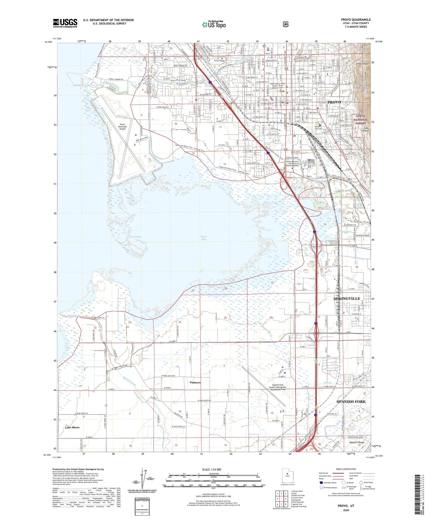
Provo Utah US Topo Map
Couldn't load pickup availability
Also explore the Provo Forest Service Topo of this same quad for updated USFS data
2023 topographic map quadrangle Provo in the state of Utah. Scale: 1:24000. Based on the newly updated USGS 7.5' US Topo map series, this map is in the following counties: Utah. The map contains contour data, water features, and other items you are used to seeing on USGS maps, but also has updated roads and other features. This is the next generation of topographic maps. Printed on high-quality waterproof paper with UV fade-resistant inks.
Quads adjacent to this one:
West: Lincoln Point
Northwest: Pelican Point
North: Orem
Northeast: Bridal Veil Falls
East: Springville
Southeast: Spanish Fork Peak
South: Spanish Fork
Southwest: West Mountain
This map covers the same area as the classic USGS quad with code o40111b6.
Contains the following named places: Big Dry Creek, Brigham Young University Emergency Medical Services, Church of the Nazarene, City of Provo, Community Congregational Church, Continental Plaza, Dixon Middle School, Dry Creek, East Bay Post High School - Central Utah Enterprises, East Bay Post Office, Farrer Junior High School, Franklin Elementary School, Gold Cross Ambulance, Harvest Bible Fellowship, Healthsouth Provo Surgical Center, Hobble Creek, Joaquin School, KDOT-AM (Provo), KEYY-AM (Provo), KFTN-AM (Provo), Kingdom Hall of Jehovahs Witnesses, KOA Campground, Lake Shore Census Designated Place, Lakeside Campground, Lower Union Canal, Maeser School, Mill Race, Palmyra, Palmyra Census Designated Place, Provo, Provo Bay, Provo City Cemetery, Provo Fire and Rescue Airport Operations Center, Provo Fire and Rescue Station 21, Provo Fire and Rescue Station 24, Provo Fire and Rescue Station 25, Provo Heliport, Provo High School, Provo Municipal Airport, Provo Police Department, Provo Post Office, Provo River, Provo Town Square, Provo United Pentacostal Church, Provost Elementary School, Riverwood Hospital, Rocky Mountain Helicopters Incorporated Heliport, Saint Francis Catholic Church, Saint Marys Episcopal Church, Seventh Day Adventist Church, Silver Fox Campground, Slate Canyon, Slide Canyon, Spanish Fork, Spanish Fork Airport-Springville-Woodhouse Field, Spring Creek, Springville Station, Sunset View Elementary School, The Church of Jesus Christ of Latter Day Saints, Timpanogos Elementary School, Uinta Post Office, Utah County Fire Department, Utah County Infirmary, Utah County Sheriff - Judicial Services, Utah County Sheriff's Office, Utah Lake State Park, Utah State Hospital, Utah Valley Hospital, Utah Valley Regional Medical Center Heliport, Utah Valley University Utah Fire and Rescue Academy, Wasatch Elementary School, ZIP Codes: 84601, 84606