MyTopo
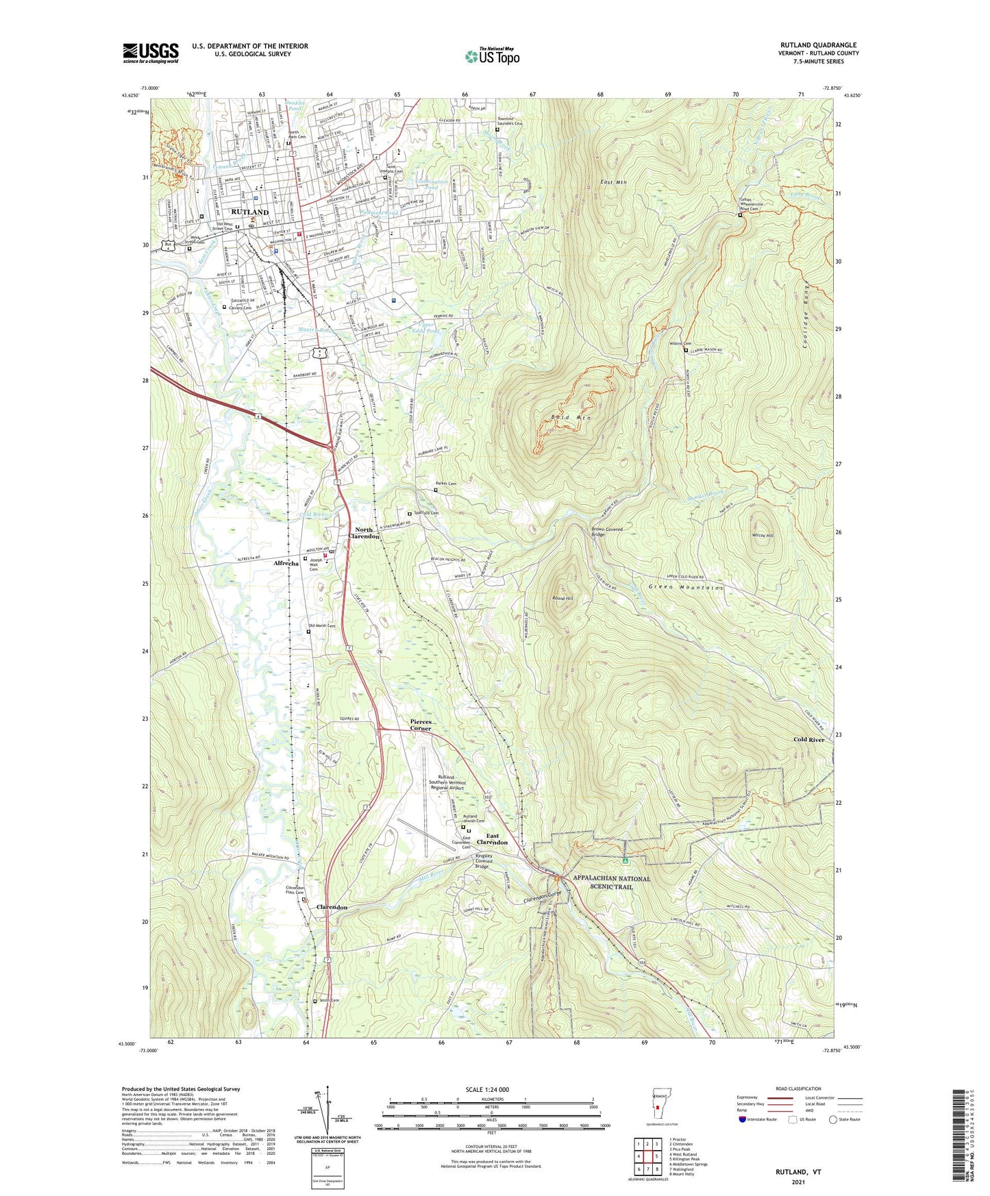
Rutland Vermont US Topo Map
Couldn't load pickup availability
Also explore the Rutland Forest Service Topo of this same quad for updated USFS data
2024 topographic map quadrangle Rutland in the state of Vermont. Scale: 1:24000. Based on the newly updated USGS 7.5' US Topo map series, this map is in the following counties: Rutland. The map contains contour data, water features, and other items you are used to seeing on USGS maps, but also has updated roads and other features. This is the next generation of topographic maps. Printed on high-quality waterproof paper with UV fade-resistant inks.
Quads adjacent to this one:
West: West Rutland
Northwest: Proctor
North: Chittenden
Northeast: Pico Peak
East: Killington Peak
Southeast: Mount Holly
South: Wallingford
Southwest: Middletown Springs
This map covers the same area as the classic USGS quad with code o43072e8.
Contains the following named places: Advent Christian Church, Aitken State Forest, Alfrecha, Alliance Church of Rutland, Bald Mountain, Bassett Development, Billings Mobile Manor, Brewers Corner, Brookside Trailer Park, Brookwood Estates, Brown Covered Bridge, Calvary Bible Church, Calvary Cemetery, Chaffee Art Center, Christ The King School, Church of Christ, Church of Christ the King Roman Catholic Church, Church of the Good Shepherd Lutheran Church, City of Rutland, City of Rutland Fire Department, Clarendon, Clarendon Congregational Church, Clarendon Elementary School, Clarendon Flats Cemetery, Clarendon Gorge, Clarendon Town Hall, Clarendon Volunteer Fire Department Station 1, Cold River, College of Saint Joseph Playhouse, Combination Pond, Community College of Vermont, Dana School, Diamond Run Mall Shopping Center, Dunklee Pond, Dyer School, East Clarenden Cemetery, East Clarendon, East Creek, East Mountain, Eastridge Acres, Eddy Brook, Eddy Pond, Eddy Pond Lower Dam, Eden Park Nursing Home, First Baptist Church, First Church of Christ Scientist, First Methodist Church, Grace Congregational Church, Grandview Acres, Green Acres, Green Mountain Shopping Plaza Shopping Center, H H Baxter Memorial Library, Havenwood School, Heritage Hill Development, Immaculater Heart of Mary Roman Catholic Church, Iroquois Land Family Campground, Joseph Wait Cemetery, Killington Heights, Kingsley Covered Bridge, Lawrence Recreation Center, Lincoln School, Longfellow School, Lydias - Wheelerville Road Cemetery, Main Street Park, Marble Valley Regional Correctional Facility - Rutland, Marolin Acres, McKerley Health Care Center, Mendon Brook, Messiah Lutheran Church, Mill River, Mill River Union High School, Moon Brook, Mount Saint Joseph Academy, Mount Saint Joseph Convent, Mussey Brook, North Branch Cold River, North Clarendon, North Clarendon Census Designated Place, North Clarendon Post Office, North Main Cemetery, Northeast Primary School, Northwest Primary School, Old Marsh Cemetery, Old West Street Cemetery, Park Street School, Parker Cemetery, Piedmont Pond, Pierces Corner, Pierpoint Primary Learning Center, Pine Hill Park, Regional Ambulance Service, Round Hill, Rutland, Rutland - Southern Vermont Regional Airport, Rutland Area Christian School, Rutland Central School District Office, Rutland City Hall, Rutland City School District Office, Rutland City Swimming Pool, Rutland Country Club, Rutland County Courthouse, Rutland County Sheriff's Office, Rutland Courthouse Historic District, Rutland Downtown Historic District, Rutland Free Library, Rutland High School, Rutland Historical Society Building, Rutland Historical Society Museum, Rutland Intermediate School, Rutland Jewish Cemetery, Rutland Jewish Center, Rutland Learning Center, Rutland Mall Shopping Center, Rutland Middle School, Rutland Plaza Shopping Center, Rutland Police Department, Rutland Post Office, Rutland Regional Medical Center, Rutland Regional Medical Center Health Science Library, Rutland South Supervisory Union, Saint Josephs Cemetery, Saint Josephs Convent, Saint Pauls Universalist Church, Saint Peters Roman Catholic Church, Saint Peters School, Salvation Army, Senior Citizens Center, Seventh Day Adventist Church, Smith Cemetery, Spafford Cemetery, Stafford Technical Center, Success School, Tenney Brook, The Synagogue, Town of Clarendon, Town of Rutland, Townline - Saunders Cemetery, Trinity Episcopal Church, Union Chapel, Upper Eddy Pond, Upper Eddy Pond Dam, Vermont Achievement Center, Vermont State Southwest Regional Library, West Street Cemetery, WFTF-FM (Rutland), Whites Playground, Wilcox Hill, Wilkins Cemetery, WSYB-AM (Rutland), ZIP Codes: 05701, 05759