MyTopo
Stowe Vermont US Topo Map
Couldn't load pickup availability
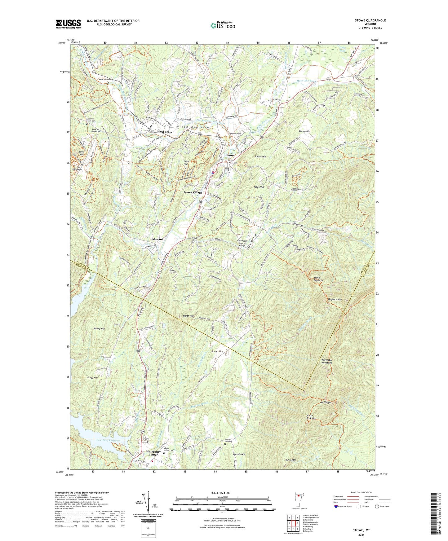
2021 topographic map quadrangle Stowe in the state of Vermont. Scale: 1:24000. Based on the newly updated USGS 7.5' US Topo map series, this map is in the following counties: Lamoille, Washington. The map contains contour data, water features, and other items you are used to seeing on USGS maps, but also has updated roads and other features. This is the next generation of topographic maps. Printed on high-quality waterproof paper with UV fade-resistant inks.
Quads adjacent to this one:
West: Bolton Mountain
Northwest: Mount Mansfield
North: Sterling Mountain
Northeast: Morrisville
East: Mount Worcester
Southeast: Montpelier
South: Middlesex
Southwest: Waterbury
Contains the following named places: 1860 House, Akeley Memorial Building, Alder Brook, Barnes Hill, Barrows Brook, Blessed Sacrament Church, Bloch Dam, Bloody Brook Schoolhouse, Brush Hill, Bryant Brook, Burnt Mountain, Cady Hill, Gold Brook, Gold Brook Campground, Gold Brook Covered Bridge, Grace Bible Church, Gregg Hill, Helen Day Memorial Library and Art Center, Hogback Mountain, Jackson Skating Area, Loomis Hill, Loomis Hill Cemetery, Lower Village, Luce Hill, Luce Hill North Cemetery, Luce Hill South Cemetery, Maple Street Cemetery, Miller Brook, Molly Pond, Moscow, Moscow Post Office, Moss Glen Brook, Mount Hunger, North Hill, Old Stowe High School, Peterson Brook, Riverbank Cemetery, Route 108 Cemetery, Saint Johns Episcopal Church, Sterling Brook, Stowe, Stowe Area Association, Stowe Census Designated Place, Stowe City Police Department, Stowe Community Church, Stowe Elementary School, Stowe Emergency Medical Services, Stowe Fire Department, Stowe Free Library, Stowe Golf Course, Stowe Historical Society Museum, Stowe Hollow, Stowe Hollow Campground, Stowe Middle / High School, Stowe Pinnacle, Stowe Post Office, Stowe Town Hall, Stowe Village Historic District, Stowe Village House, Stowe Village Municipal Offices, Sunset Hill, Taber Hill, The Standard Church, Topnotch Ski Touring Center, Town of Stowe, Town of Waterbury, Trapp Family Cemetery, Trapp Family Lodge and Cross Country Ski Center, Vermont Ski Museum, Village Center Cemetery, Waterbury Center, Waterbury Center Census Designated Place, Waterbury Center Community Church, Waterbury Center Library, Waterbury Fire Department Maple Street Station, Waterbury Grange Hall, West Branch, West Branch Cemetery, West Branch Little River, WGLY-FM (Waterbury), White Rock Mountain, Willey Hill, ZIP Codes: 05672, 05677