MyTopo
Morrisville Vermont US Topo Map
Couldn't load pickup availability
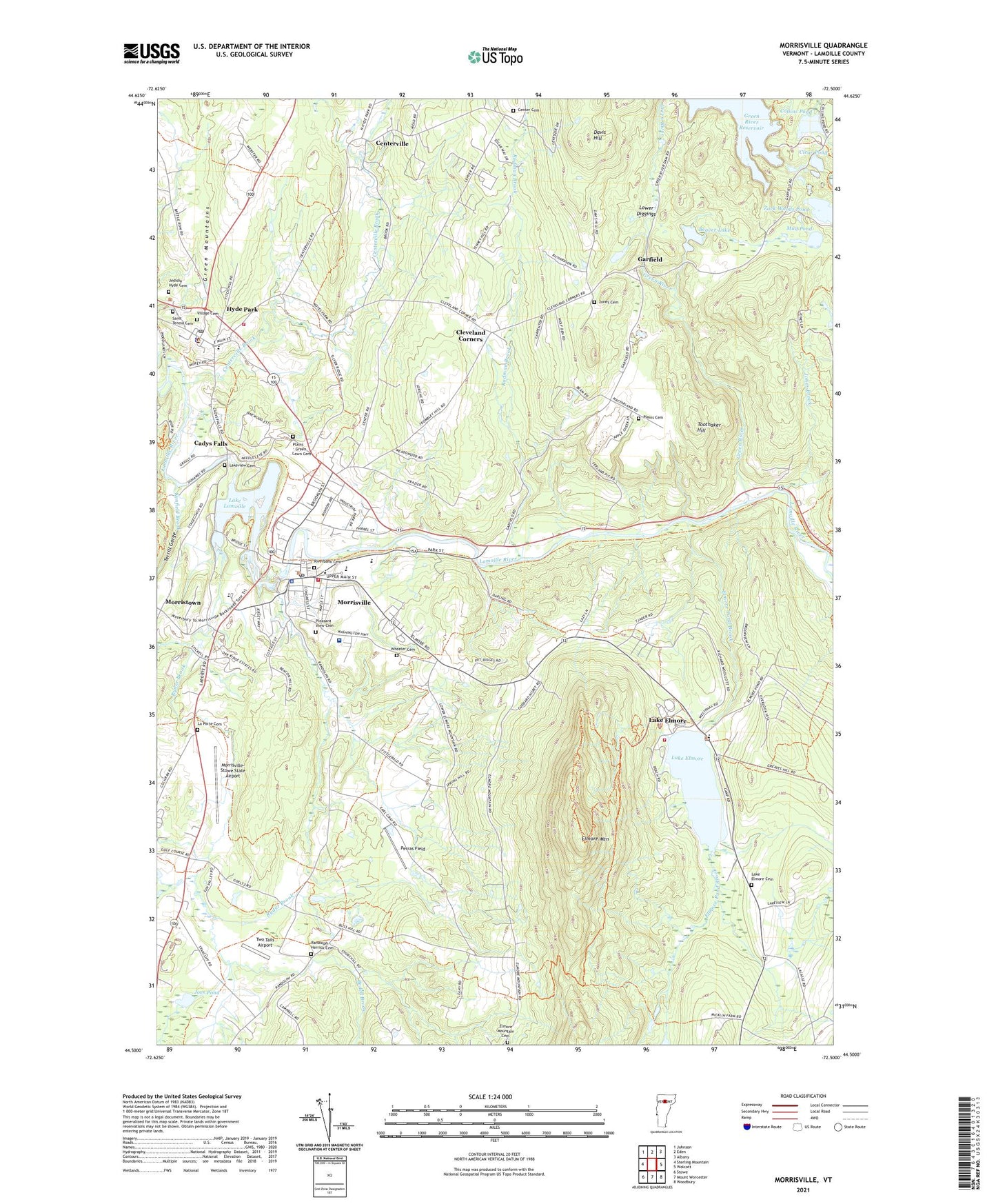
2024 topographic map quadrangle Morrisville in the state of Vermont. Scale: 1:24000. Based on the newly updated USGS 7.5' US Topo map series, this map is in the following counties: Lamoille. The map contains contour data, water features, and other items you are used to seeing on USGS maps, but also has updated roads and other features. This is the next generation of topographic maps. Printed on high-quality waterproof paper with UV fade-resistant inks.
Quads adjacent to this one:
West: Sterling Mountain
Northwest: Johnson
North: Eden
Northeast: Albany
East: Wolcott
Southeast: Woodbury
South: Mount Worcester
Southwest: Stowe
This map covers the same area as the classic USGS quad with code o44072e5.
Contains the following named places: Advent Christian Church, Agape Baptist Fellowship Church, Augmentative Learning and Movement Center, Beaver Lake, Beaver Lake Dam, Beaver Pond, Bedell Brook, Bishop Marshall School, Cadys Falls, Cadys Falls Dam, Center Cemetery, Centerville, Centerville Brook, Clear Pond, Cleveland Corners, Collins Pond, Community College of Vermont, Copley Country Club, Copley Hospital, Copley Hospital Medical Library, Cornerstone Foursquare Church, Davis Hill, Delano School, Elmore Fire Department, Elmore Mountain, Elmore Mountain Cemetery, Elmore Pond Brook, Elmore School, Elmore State Park, Elmore United Methodist Church, Fairground Plaza, Farm Resort Golf Course, First Congregational Church, Garfield, Grant Building, Green River, Holy Cross Catholic Church, Hyde Park, Hyde Park Courthouse, Hyde Park Elementary School, Hyde Park Opera House, Hyde Park Post Office, Hyde Park Town Fire Department, Hyde Park Town Offices, Jedidia Hyde Cemetery, Joes Pond, Jones Brook, Jones Cemetery, Kenfield Brook, La Porte Cemetery, Lake Elmore, Lake Elmore Cemetery, Lake Elmore Dam, Lake Elmore Post Office, Lake Lamoille, Lakeview Cemetery, Lamoille County Sheriff's Office, Lamoille Family Center, Lamoille Grange, Lamoille Valley Chamber of Commerce, Lamoille Valley Learning Together, Lamoille Valley Railroad Depot, Lawrence Brook, Lower Diggings, McKerley Health Care Center, Morristown, Morristown Centennial Library, Morristown Elementary School, Morristown Police Department, Morristown Rescue Squad, Morrisville, Morrisville Armory Heliport, Morrisville Baptist Church, Morrisville Dam, Morrisville Fire Department, Morrisville Graded School, Morrisville Historic District, Morrisville Plaza Shopping Center, Morrisville Post Office, Morrisville Village Forest, Morrisville Village Municipal Forest, Morrisville-Stowe State Airport, Mountain View Cottages and Campgrounds, Mud Pond, Northgate Plaza Shopping Center, Peoples Academy High School, Peoples Academy Middle School, Perras Field, Plains - Green Lawn Cemetery, Plains Cemetery, Pleasant View Cemetery, Puffer United Methodist Church, Randolph - Herrick Cemetery, Riverbank Cemetery, Rodman Brook, Ryder Brook, Saint Teresa Cemetery, Saint Theresa Catholic Church, Second Congregational Church, Terrill Gorge, The Mennonite School, Toothaker Hill, Town of Hyde Park, Two Tails Airport, Union Meeting House, Village Cemetery, Village of Hyde Park, Village of Morrisville, Wheeler Cemetery, Zack Woods Pond, ZIP Codes: 05655, 05657, 05661