MyTopo
Boyce Virginia US Topo Map
Couldn't load pickup availability
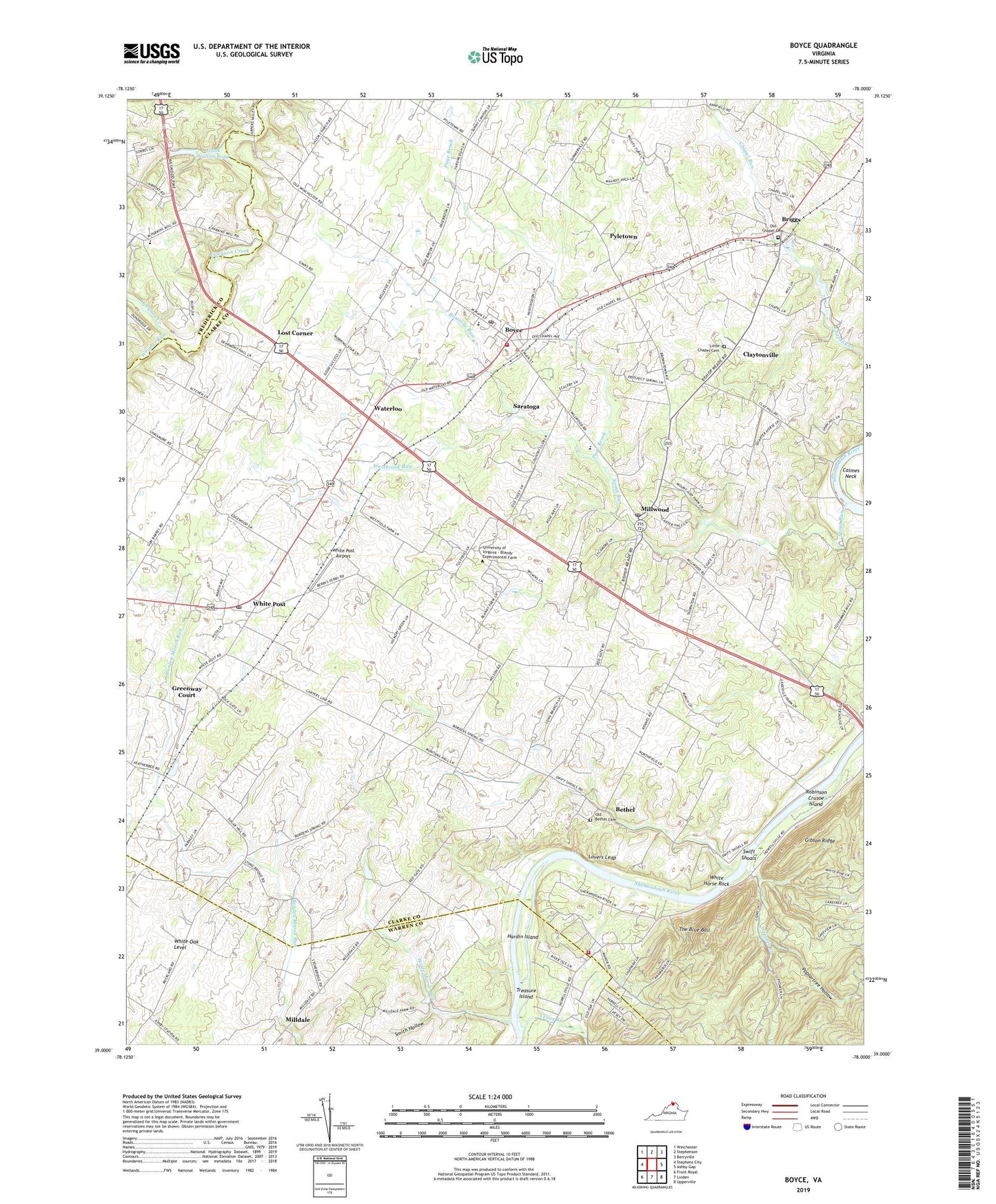
2022 topographic map quadrangle Boyce in the state of Virginia. Scale: 1:24000. Based on the newly updated USGS 7.5' US Topo map series, this map is in the following counties: Clarke, Warren, Frederick. The map contains contour data, water features, and other items you are used to seeing on USGS maps, but also has updated roads and other features. This is the next generation of topographic maps. Printed on high-quality waterproof paper with UV fade-resistant inks.
Quads adjacent to this one:
West: Stephens City
Northwest: Winchester
North: Stephenson
Northeast: Berryville
East: Ashby Gap
Southeast: Upperville
South: Linden
Southwest: Front Royal
This map covers the same area as the classic USGS quad with code o39078a1.
Contains the following named places: Bethel, Blue Ridge Downs, Boyce, Boyce Baptist Church, Boyce Elementary School, Boyce Methodist Church, Boyce Post Office, Boyce Volunteer Fire Company, Briggs, Burwells Mill, Carter Hall, Chapel Estates, Chapel Green Estate, Chapel Hill Estate, Clay Hill Estate, Claytonville, Cunningham Parish Chapel, Dearmont Chase, Ebenezer Primitive Baptist Church, Emmanuel Chapel Episcopal Church, Farnley Estate, Federal Hill Estate, Gaywood Estate, Gibson Ridge, Glenvin Estate, Goshen Estate, Greenville Estate, Greenway Court, Greenway Estates, Guilfield Church, Guilford Estate, Hampton Estate, Hardin Island, Huntingdon, Izaak Walton Park, Izaak Walton Park Pond Dam, Izaak Walton Pond, Lakeville Estate, Little Chapel, Little Chapel Cemetery, Long Branch Estate, Longwood Estate, Lost Corner, Lovers Leap, Lucky Hit Estate, Marsh Thoroughbred Farm, Mead Memorial Church, Milldale, Milldale Farms, Millwood, Millwood Church, Millwood Country Club, Millwood Farm Equestrian Center, Millwood Post Office, Millwood United Methodist Church, Morgan Mill, Mount Olive Baptist Church, Mount Zion, Mountain View Estate, New Market Estate, Oak Hill Silk Farm, Oakley Estate, Old Bethel Cemetery, Old Bethel Church, Old Chapel, Old Chapel Cemetery, Page Brook, Pagebrook Estate, Poplar Hill Estate, Poplartree Hollow, Powhatan School, Prospect Farms, Providence Estate, Pyletown, Robinson Crusoe Island, Rosemont Estate, Roseville Run, Rosney Estate, Sandstone Farms, Saratoga, Shenandoah Farms Baptist Church, Shenandoah Farms Volunteer Fire Department and Rescue Squad, Shenandoah Farms Volunteer Fire Department Company 6, Shiloh Baptist Church, Slonaker Orchard, Smith Hollow, Soldiers Retreat Estate, Spout Run, Stone Bridge, Sugar Hill, Summerville Estate, Sunnybrook, Swift Shoals, The Blue Ball, The Briars, The Meadow Estate, The Vineyard Estate, Town of Boyce, Treasure Island, Tuleyries Estate, University of Virginia - Blandy Experimental Farm, Venus Branch, Waterloo, Waterloo Heights, Westbrook Estate, Westbrook Run, White Horse Rock, White Oak Level, White Post, White Post Airport, White Post Dairy, White Post District, White Post Historic District, White Post Methodist Church, White Post Post Office, White Post Village Park, Winchester Montessori School, Wolfe Marsh Run, Wrights Branch, Wrights Run, Zion Baptist Church, ZIP Codes: 22620, 22646, 22663