MyTopo
Blacksburg Virginia US Topo Map
Couldn't load pickup availability
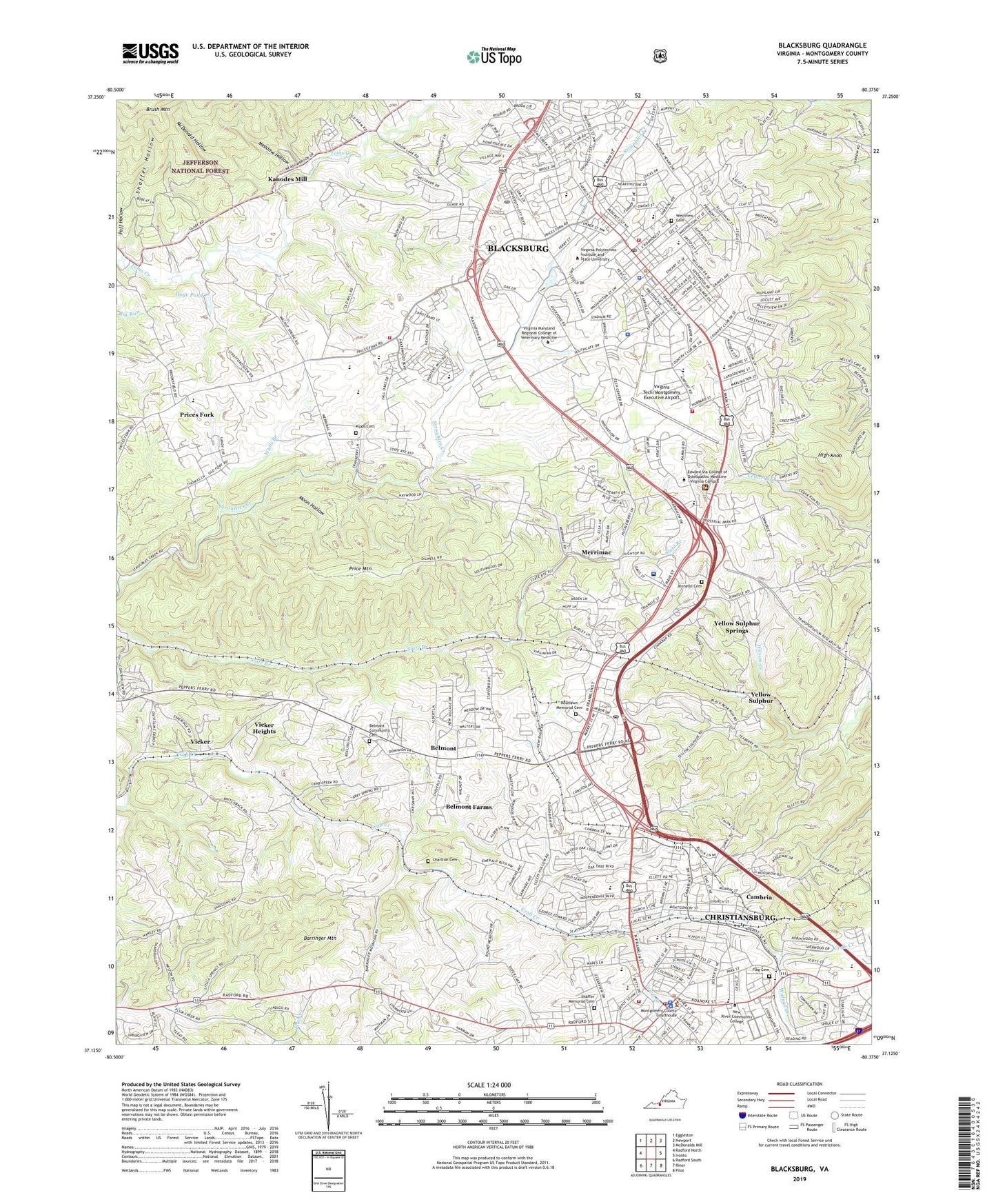
2019 topographic map quadrangle Blacksburg in the state of Virginia. Scale: 1:24000. Based on the newly updated USGS 7.5' US Topo map series, this map is in the following counties: Montgomery. The map contains contour data, water features, and other items you are used to seeing on USGS maps, but also has updated roads and other features. This is the next generation of topographic maps. Printed on high-quality waterproof paper with UV fade-resistant inks.
Quads adjacent to this one:
West: Radford North
Northwest: Eggleston
North: Newport
Northeast: McDonalds Mill
East: Ironto
Southeast: Pilot
South: Riner
Southwest: Radford South
Contains the following named places: Agnew Hall, Airport Acres, Alleghany Addition, Alleghany School, Ambler Johnston Hall - East Wing, Apperson Park, Apple Acres, Bangs, Barringer Mountain, Belmont, Belmont Community Cemetery, Belmont Estates, Belmont Farms, Belmont School, Berryfield, Beverly Hills, Blacksburg, Blacksburg Area Branch Library, Blacksburg Christian School, Blacksburg City Hall, Blacksburg High School, Blacksburg Historic District, Blacksburg Middle School, Blacksburg Post Office, Blacksburg Quarry, Blackwood, Blue Ridge Court, Brightwood Manor, Brodie Hall, Brumfield Acres, Burruss Hall, Cambria, Cambria Historic District, Campbell Hall - Main Wing, Carma Heights, Carriage Hill, Cassell Coliseum, Cedar Orchard, Charlton Cemetery, Cheatham Hall, Chowning Place, Christiansburg, Christiansburg City Hall, Christiansburg Elementary School, Christiansburg High School, Christiansburg Industrial School, Christiansburg Institute, Christiansburg Post Office, Christiansburg Primary School, Christiansburg Primary School Number 1, Christiansburg Primary School Number 2, Christiansburg Recreation Center, Clover Valley, Cochrane Hall, Country Club Park, Cowgill Hall, Craig Mountain, Crestwood Gardens, Davidson Hall, Dayspring Christian Academy, Derring Hall, Diamond Pointe, Dickerson, Dietrick Hall, District B-01, Downtown Blacksburg Post Office, Downtown Christiansburg Post Office, Dundas Heights, Dunton Addition, East Main Street Historic District, East Park Addition, Echo Hills, Eggleston Hall - Main Wing, Engel Hall, English Baseball Field, English Field, Evergreen, Fairview School, Farmview, Femoyer Hall, Flag Cemetery, Forest Hills, Friends School, G. Burke Johnston Student Center, Gables Shopping Center, Gilbert Linkous Elementary School, Glade Road Heights, Glade School, Gladewood, Graduate Life Center at Donaldson Brown, Hahn Hall - South Wing, Hancock Hall, Hans Meadow, Harding Avenue Elementary School, Harmon Forest, Henderson Student Health Service Building, Henley Place, Hethwood, Hethwood Square Shopping Center, High Knob, Highland Park, Hills Shopping Center, Hilltop Plaza, Hoge Pond, Holden Hall, Hubbard Haven, Hunters Ridge, Independence Secondary School, Jennelle Cemetery, Johnson Heights, Kanodes Mill, Karr Heights, Keister Addition, Kessler Park, Kipps Cemetery, Kipps Elementary School, Knob Hill, La Plateau, Lane Stadium, Lee-Hi Court, Lester Place, LewisGale Hospital Montgomery, Linkous, Longview Estates, Lowes Shopping Center, Margaret Beeks Elementary School, McBryde Village, McDonald Hollow, Meadow Hollow, Merrimac, Merrimac Census Designated Place, Midway Heights, Miller Addition, Miller-Johnson Track/Soccer Complex, Miller-Southside Historic District, Mission Hills, Montgomery County, Montgomery County Park, Montgomery Farms, Moon Hollow, Mosely Practice Field, Mountain View Estates, Mountain View Park, Murphy, Myers Acres, New Altamont Hospital, New River Community College, New River Valley Mall Shopping Center, Newcomb Heights, Nicholas Manor, Northgate Village Shopping Center, Oak Manor, Oakwood Park, Old Farm Village, Old Hecks Shopping Center, Old Hill School, Orchard View, Patrick Henry Centre Shopping Center, Patrick Henry Place, Pheasant Run, Piedmont, Pilgrims Pointe, Price Mountain, Prices Fork, Prices Fork Census Designated Place, Prices Fork Elementary School, Prices Fork Historic District, Prices Fork Research Center, Rainbow Ridge, Raintree Village, Ramble Ridge, Rock Road School, Rolling Hills, Roselawn Memorial Cemetery, Round Meadow Country Club, Saint John Neumann Academy, Shaffer Hollow, Shaffer Memorial Cemetery, Shelor Acres, Shenandoah, Sherwood Forest, Silver Lake Heights, Silver Leaf, Sleepy Hollow, Smithfield Plantation, Snidow Heights, South Franklin Street Historic District, Southeast Park, Southgate, Spradlin Addition, Stonegate, Stroubles Mill, Suburban Hills, Sundance Ridge, Sundance Village, Swanee Hollow Country Club, Tall Oaks Montessori School, Tekoa Community School, The Marketplace Shopping Center, The Orchard, The Vistas, Town Branch, Town of Blacksburg, Town of Christiansburg, Tremont Estates, University Mall Shopping Center, University Place, University Terrace, Vicker, Vicker Heights, Victory Heights, Virginia Maryland Regional College of Veterinary Medicine, Virginia Polytechnic Institute and State University, Virginia Polytechnic Institute and State University Horticultural Research Area, Virginia Tech Golf Course, Virginia Tech/Montgomery Executive Airport, Vista Via, Walls Branch, Walnut Branch, Weller Baker School, Westover Hills, Westview Cemetery, Wheeler Baker School, Whitehurst Hall, Windmill Hills, WJJJ Radio Tower (Tazewell), WJJJ-AM (Christiansburg), WKEX-AM (Blacksburg), Woodlyn, WUVT-FM (Blacksburg), WVVV-FM (Blacksburg), Yellow Sulphur, Yellow Sulphur Springs, Yellow Sulphur Springs Post Office, ZIP Code: 24073