MyTopo
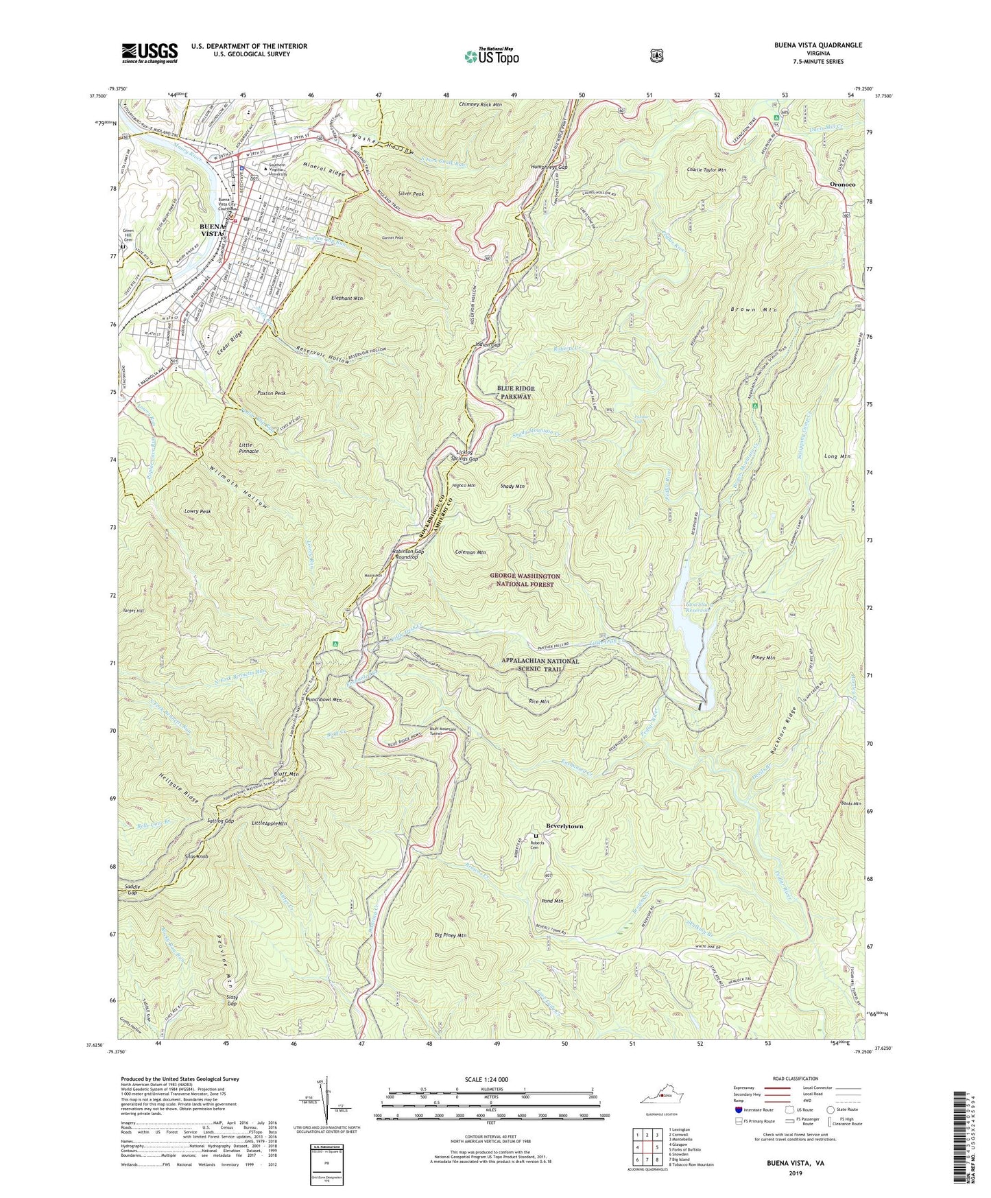
Buena Vista Virginia US Topo Map
Couldn't load pickup availability
Also explore the Buena Vista Forest Service Topo of this same quad for updated USFS data
2022 topographic map quadrangle Buena Vista in the state of Virginia. Scale: 1:24000. Based on the newly updated USGS 7.5' US Topo map series, this map is in the following counties: Amherst, Rockbridge, Buena Vista (city). The map contains contour data, water features, and other items you are used to seeing on USGS maps, but also has updated roads and other features. This is the next generation of topographic maps. Printed on high-quality waterproof paper with UV fade-resistant inks.
Quads adjacent to this one:
West: Glasgow
Northwest: Lexington
North: Cornwall
Northeast: Montebello
East: Forks of Buffalo
Southeast: Tobacco Row Mountain
South: Big Island
Southwest: Snowden
This map covers the same area as the classic USGS quad with code o37079f3.
Contains the following named places: Admissions Building, Ann B Stoddard Living Center, Arthur House, Beverlytown, Big Piney Mountain, Blue Ridge Baptist Church, Bluff Creek, Bluff Mountain, Bluff Mountain Overlook, Bluff Mountain Tunnel, Brown Mountain, Brown Mountain Creek, Brown Mountain Creek Shelter, Browns Creek, Buckhorn Ridge, Buena Vista, Buena Vista Baptist Church, Buena Vista Fire Department Company 10, Buena Vista Overlook, Buena Vista Police Department, Buena Vista Post Office, Buena Vista Presbyterian Church, Buena Vista Rescue Squad, Buena Vista Sheriff's Office, Buena Vista Town Hall, Camelot House, Cedar Ridge, Chalk Mine Run, Charlie Taylor Mountain, Christ Episcopal Church, Church of God, Church of God of Prophecy, Church of the Good Shepherd, City of Buena Vista, Coleman Mountain, Craton Hall, Dancing Creek Overlook, Davis Mill Creek, Devils Branch, Elephant Mountain, Enchanted Creek, Enderly Heights, Enderly Heights Elementary School, F W Kling Jr Elementary School, Fawson House, Ferrel House, First Apostolic Church of Buena Vista, First Baptist Church, First Brethren Church, First Evangelical Methodist Church, Garnet Peak, Glen Maury Park, Hellgate Ridge, Highco Mountain, House Mountain Overlook, Humphreys Gap, Indian Gap, Indian Gap Run, Keys Mill Dam, Knight Guest House, Knight Sports Arena, Lady Slipper Run, Lancelot House, Landrum House, Laurel Park, Licklog Springs Gap, Little Apple Mountain, Little Irish Creek, Little Pinnacle, Long Mountain, Lowry Peak, Lynchburg Reservoir, Mineral Ridge, Moore Mountain, Noels Run, Nyman House, Oronoco, Oronoco Campground, Oronoco Church, Oronoco School, Panther Falls, Park Avenue School, Parry McCluer High School, Parry McCluer Middle School, Paxton Peak, Peavine Mountain, Pedlar Gap Run, Pedlar River Dam, Pedlar Work Center, Pentecostal Holiness Church, Peoples Memorial United Methodist Church, Piney Mountain, Pleasantview Hunt Club Dam, Pond Mountain, Poplar Cove Run, President's House - Southern Virginia University, Punchbowl Mountain, Punchbowl Shelter, Racy Acres, Reservoir Hollow, Rice Mountain, Rice Mountain Overlook, Roberts Cemetery, Roberts Creek, Robey Hall, Robinson Gap, Roundtop, Saddle Gap, Saint Johns United Methodist Church, Saltlog Gap, Seventh Day Adventist Church, Shady Mountain, Shady Mountain Campground, Shady Mountain Creek, Silas Knob, Silver Peak, Skulking Branch, Slaty Gap, South Fork Chalk Run, Southern Seminary Junior College, Southern Virginia University, Spring Lake, Stone Church of the Brethren, Student Life Office Building, Swapping Camp Creek, Target Hill, The Peoples Baptist Church, Tucson House, Union Station, Von Canon Library, Washer Hollow, White Oak Plats Overlook, Wilmoth Hollow, ZIP Code: 24416