MyTopo
Chancellorsville Virginia US Topo Map
Couldn't load pickup availability
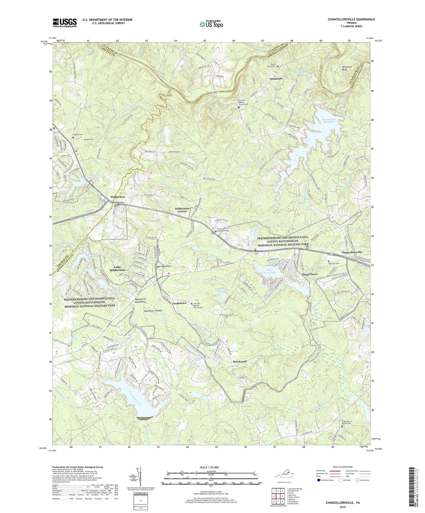
2022 topographic map quadrangle Chancellorsville in the state of Virginia. Scale: 1:24000. Based on the newly updated USGS 7.5' US Topo map series, this map is in the following counties: Spotsylvania, Orange, Culpeper. The map contains contour data, water features, and other items you are used to seeing on USGS maps, but also has updated roads and other features. This is the next generation of topographic maps. Printed on high-quality waterproof paper with UV fade-resistant inks.
Quads adjacent to this one:
West: Mine Run
Northwest: Germanna Bridge
North: Richardsville
Northeast: Storck
East: Salem Church
Southeast: Spotsylvania
South: Brokenburg
Southwest: Belmont
This map covers the same area as the classic USGS quad with code o38077c6.
Contains the following named places: Ashbys Dam, Ashbys Pond, Aunt Sarah Spring Creek, Beech Grove Cemetery, Beech Grove Church, Black Meadow Creek, Brock Road Elementary School, Brock Run, Brockroad, Cattail Branch, Chancellor District, Chancellorsville, Chancellorsville Battlefield, Cookstown, Cool Spring Lake, Cool Spring Lake Dam, Dunavant, Elys Ford, Elys Ford Baptist Church Cemetery, Elys Ford Church, Fairview Cemetery, Faulkner Run, Fawn Lake, Fawn Lake Country Club, Fawn Lake Dam, Fishing Run, Fredericksburg and Spotsylvania County Battlefields Memorial National Military Park, Fredericksburg and Spotsylvania National Military Park, Grant Lake, Grant Lake Dam, Hamiltons Thicket, Hays Monument, Hazel Grove, Hazel Grove Lake, Hazel Grove Lake Dam, Hazel Run, Horseshoe Bend, Hunting Run, Hunting Run Dam, Hunting Run Park, Hunting Run Reservoir, Jackson Trail, John Jones Run, Keatons Run, Lake of the Woods Dam Number Two, Lake of the Woods Number Two, Lake of the Woods Volunteer Fire Department and Rescue Squad, Lake Wilderness Census Designated Place, Laurel Hill Memorial Park, Laytons Branch, Lee Lake, Lee Lake Dam, Lewis Run, Little Hunting Run, Locust Grove Post Office, Middle Run, Mine Run, Mount Olive Church, Ni River Middle School, North Wilderness Run, Orange County Rescue Squad Station 29, Parker School, Paynes Store, Pilgrim Cemetery, Pilgrim Church, Piney Branch Baptist Cemetery, Piney Branch Church, Piney Branch School, Powell Branch, Rising Sun Church, Saint Patrick School, Saint Patricks Catholic Church, Shotgun Hill, Shotgun Hill Branch, South Wilderness Run, Spotsylvania County Fire and Rescue Station 7, Spring Creek, Wadsworth Monument, Waltonian Pond, Wash Branch, Widow Tapp Spring Drain, Wilderness, Wilderness Bridge, Wilderness Cemetery, Wilderness Church, Wilderness Corner, Wilderness Elementary School, Wilderness Park Estates Dam, Wilderness Run Lake, Zion Hill Baptist Church Cemetery, Zion Hill Church, ZIP Code: 22553