MyTopo
Storck Virginia US Topo Map
Couldn't load pickup availability
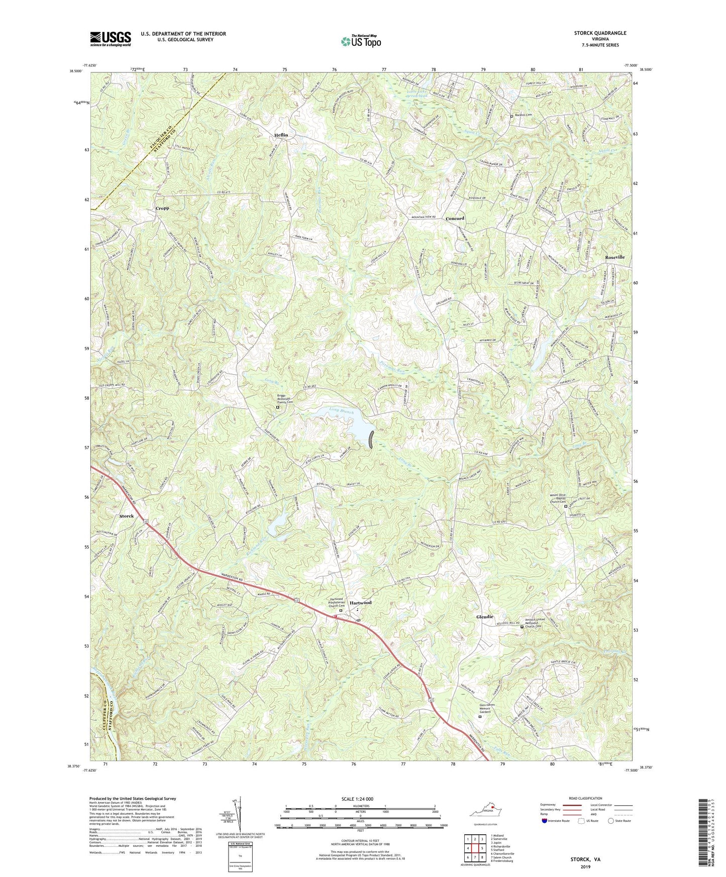
2022 topographic map quadrangle Storck in the state of Virginia. Scale: 1:24000. Based on the newly updated USGS 7.5' US Topo map series, this map is in the following counties: Stafford, Fauquier, Culpeper. The map contains contour data, water features, and other items you are used to seeing on USGS maps, but also has updated roads and other features. This is the next generation of topographic maps. Printed on high-quality waterproof paper with UV fade-resistant inks.
Quads adjacent to this one:
West: Richardsville
Northwest: Midland
North: Somerville
Northeast: Joplin
East: Stafford
Southeast: Fredericksburg
South: Salem Church
Southwest: Chancellorsville
This map covers the same area as the classic USGS quad with code o38077d5.
Contains the following named places: Amsonia, Antioch Church, Antioch United Methodist Church Cemetery, Ashburn Hills, Barrington Woods, Beach, Beverly Estates, Brandy Hills, Briggs-McDonald Family Cemetery, Cannon Knolls, Carrera Estates, Cedar Knolls Estates, Chesterfield, Chesterwood, Christy Farm, Colonial Beach Rescue Squad Station 1, Concord, Concord Estates, Cool River, Country Wood Estates, Crestwood, Cropp, Cropp Post Office, Cropp Road Estates, Crown Manor, Curtis Memorial Park, Curtis Memorial Park Dam, Curtis Park Lake, Curtis Park Lake Boat Ramp, Cypress Estates, Davis Corner, Deep Run, Diamond Park, Dodds Corner, Eagles Nest, Gauntlet Estates, Gauntlet Golf Course, Georgetown West, Glen Haven Memory Gardens, Glendie, Grace Church, Hampshire Forest, Hartlake Estates, Hartwood, Hartwood Airport, Hartwood District, Hartwood Elementary School, Hartwood Manor, Hartwood Meadows, Hartwood Post Office, Hartwood Presbyterian Church, Hartwood Presbyterian Church Cemetery, Hartwood Village, Hartwood Winery, Harwill Acres, Heflin, Hoys Way, Hunters Pond, Ivyglen, Keatwood, Kings Grant, Lakeland Forest, Laurelwood, Little Lake Arrowhead, Little Lake Arrowhead Dam, Long Branch, Majestic Ridge Estates, Manor Wood Estates, Mansefield, Marsh Run Estates, Milburn Estates, Mount Olive Baptist Church Cemetery, Mount Olive Church, Mount Olive School, Nellie Estates, Norwood Hills, Parkside, Paynes Corner, Potomac Chapel, Potomac Run, Rappahannock Ridge Estates, Red Hill, Richland Church, Richland Forest, Richland Run, Rock Hill Church, Rockhill Cemetery, Rose Hill Farms, Rosedale, Roseville, Roseville Heights, Roseville Plantation, Rosewood Estates, Royal Hills Estates, Seven Lakes, Seymour Knolls, Shackelford Estates, Shackleford Well, Sherwood Forest, Skidmore Corner, Skyline Hills, Stafford County Fire and Rescue Department Station 6 Hartwood, Stefaniga, Stefaniga Road, Stonehouse Wooded Estates, Stony Hill Estates, Storck, Storck Run, Tacketts Farm, The Blake Farm, The Cascades, The Estates, The Preserve on Aquia Creek, The Willows, Timberidge, Valhalla, Walden Ten, Water Edge Estates, Whitestone, Willowmere, Willowmere Park, Windsor Forest, Winslow Heights, ZIP Codes: 22406, 22556