MyTopo
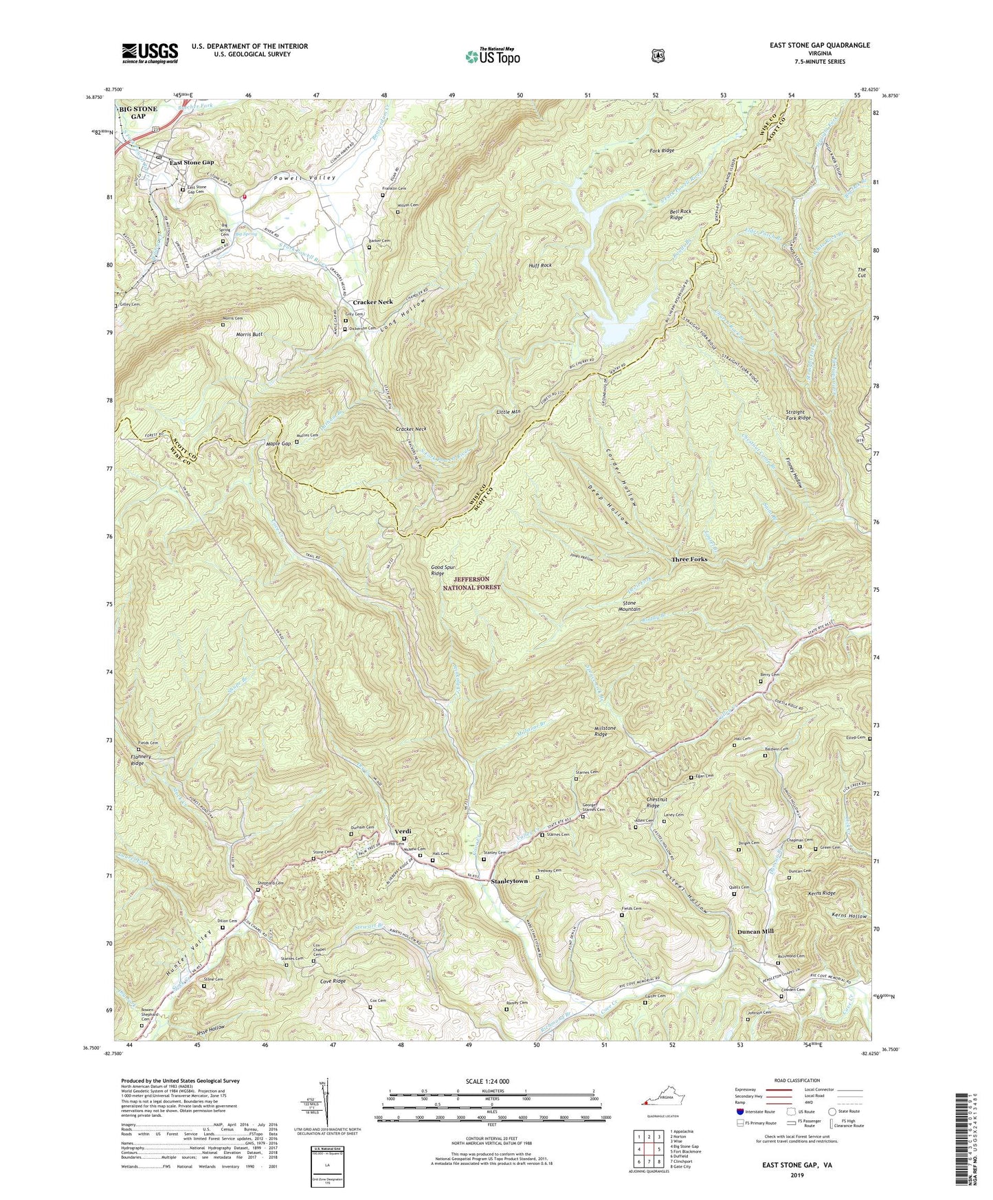
East Stone Gap Virginia US Topo Map
Couldn't load pickup availability
Also explore the East Stone Gap Forest Service Topo of this same quad for updated USFS data
2022 topographic map quadrangle East Stone Gap in the state of Virginia. Scale: 1:24000. Based on the newly updated USGS 7.5' US Topo map series, this map is in the following counties: Scott, Wise. The map contains contour data, water features, and other items you are used to seeing on USGS maps, but also has updated roads and other features. This is the next generation of topographic maps. Printed on high-quality waterproof paper with UV fade-resistant inks.
Quads adjacent to this one:
West: Big Stone Gap
Northwest: Appalachia
North: Norton
Northeast: Wise
East: Fort Blackmore
Southeast: Gate City
South: Clinchport
Southwest: Duffield
This map covers the same area as the classic USGS quad with code o36082g6.
Contains the following named places: Allen Cemetery, Baldwin Cemetery, Barker Cemetery, Beaverdam Creek, Bell Rock Ridge, Berry Cemetery, Big Cherry Dam, Big Cherry Reservoir, Big Oak Branch, Big Spring, Big Spring Cemetery, Bowen-Shephard Cemetery, Butcher Fork, Carter Cemetery, Casteel Hollow, Chapman Cemetery, Chestnut Camp Branch, Chestnut Ridge, Church Rock Branch, Corder Hollow, Cove Ridge, Cowden Cemetery, Cox Cemetery, Cox Chapel, Cox Chapel Cemetery, Cox Place, Cracker Neck, Cracker Neck Church, Cracker Neck School, Deep Hollow, Devil Fork, Dickerson Cemetery, Dillon Cemetery, Dingus Cemetery, District 3, Dry Creek, Dry Fork, Duncan Branch, Duncan Cemetery, Duncan Mill, Durham Branch, Durham Cemetery, Durham Chapel, East Stone Gap, East Stone Gap Cemetery, East Stone Gap Census Designated Place, East Stone Gap Post Office, Egan Cemetery, Elder Patch Branch, Estep Cemetery, Fields Cemetery, Finney Hollow, Fork Ridge, Franklin Cemetery, George Starnes Cemetery, Gilley Cemetery, Gilly Cemetery, Good Spur Ridge, Green Cemetery, Hall Cemetery, Hill Cemetery, Huff Rock, Jesse Hollow, Johnson Cemetery, Jones Hollow, Kerns Ridge, Lane Camp Branch, Laney Cemetery, Laurel Branch, Laurel Fork, Little Mountain, Long Hollow, Mabe, Maple Gap, McNew Cemetery, Midway Church, Midway School, Millstone Branch, Millstone Ridge, Mintons Store, Morris Butt, Morris Cemetery, Mullins Cemetery, Pendleton Church, Pendleton School, Powell Valley, Powell Valley Airport, Qualls Cemetery, Ramey Cemetery, Richmond Branch, Richmond Cemetery, Riggs, Roads Branch, Roddy Branch, Saint Branch, Shephard Cemetery, Shupe Branch, Spruce Lick Branch, Stanley Cemetery, Stanleytown, Starnes Cemetery, Stewart Branch, Stinking Creek, Stone Cemetery, Straight Fork Ridge, The Cut, Three Forks, Tredway Cemetery, Valley Creek, Valley Creek Church, Valley Creek School, Valley Volunteer Fire Department, Verdi, WAXM-FM (Big Stone Gap), White Rock Branch, Wildcat Creek, Wilson Cemetery, WLSD-AM (Big Stone Gap), ZIP Code: 24246