MyTopo
Norton Virginia US Topo Map
Couldn't load pickup availability
Also explore the Norton Forest Service Topo of this same quad for updated USFS data
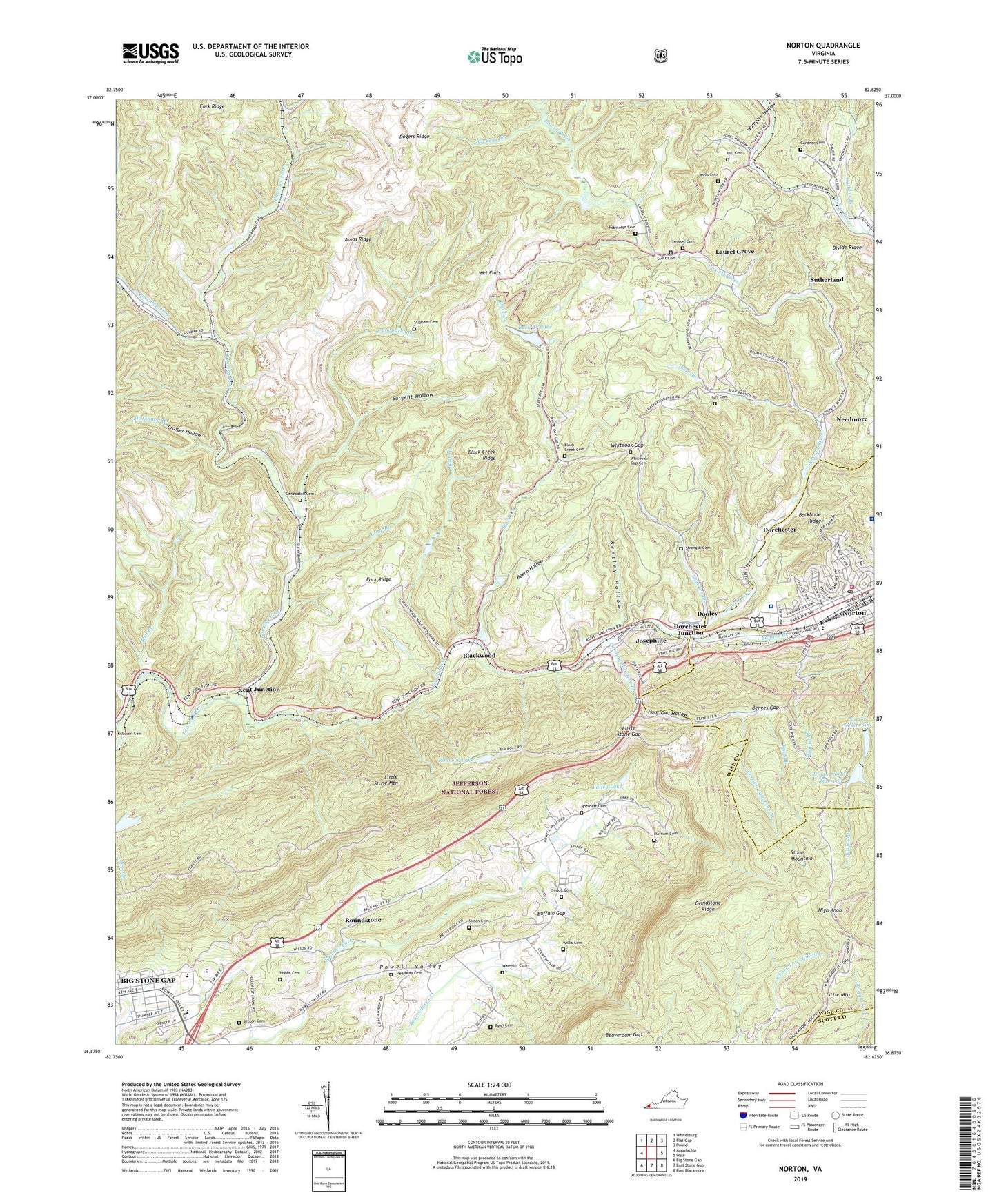
2022 topographic map quadrangle Norton in the state of Virginia. Scale: 1:24000. Based on the newly updated USGS 7.5' US Topo map series, this map is in the following counties: Wise, Norton (city), Scott. The map contains contour data, water features, and other items you are used to seeing on USGS maps, but also has updated roads and other features. This is the next generation of topographic maps. Printed on high-quality waterproof paper with UV fade-resistant inks.
Quads adjacent to this one:
West: Appalachia
Northwest: Whitesburg
North: Flat Gap
Northeast: Pound
East: Wise
Southeast: Fort Blackmore
South: East Stone Gap
Southwest: Big Stone Gap
This map covers the same area as the classic USGS quad with code o36082h6.
Contains the following named places: Amos Ridge, Appalachia Elementary School, Back Creek Dam, Back Creek Lake, Backbone Ridge, Bear Branch, Beaverdam Gap, Beech Hollow, Benges Branch, Benges Gap, Bentley Hollow, Big Stone Gap, Big Stone Gap East Census Designated Place, Black Creek, Black Creek Cemetery, Black Creek Ridge, Black Creek School, Blackwood, Blue Springs Church, Boatwrights Store, Buckeye Branch, Buffalo Church, Buffalo Gap, Buffalo School, Canepatch, Canepatch Cemetery, Canepatch Creek, Carding Machine Branch, Central Freewill Baptist Church, City of Norton, Craiger Hollow, Deadman Curve, Dooley, Dorchester, Dorchester Junction, Dunbar, Dunbar Census Designated Place, Egan Cemetery, First Baptist Church, Flag Rock Recreation Site, Fork Ridge, Gabe Branch, Gardner Cemetery, Gardner School, Gibson Cemetery, Graden, Grindstone Ridge, Guest River Chapel, Haddox Branch, High Knob, High Knob Lookout Tower, Hill Cemetery, Hobbs Cemetery, Hoot Owl Church, Hoot Owl Hollow, Huff Cemetery, Humphreys Heliport, John I Burton High School, Josephine, Kelly View, Kelly View School, Kent Junction, Knob Branch, Laurel Grove, Legion Memorial Church, Little Stone Gap, Little Stone Mountain, Locust Grove Church, Lonesome Pine Country Club, Lower Norton Reservoir, Lower Norton Reservoir Dam, Marcum Cemetery, McKinney Branch, Mill Branch, Mountain View Regional Medical Center, Needmore, Norton, Norton City Sheriff's Office, Norton Community Hospital, Norton Community Hospital Heliport, Norton Fire Department, Norton Police Department, Norton Post Office, Norton Quarry, Norton Rescue Squad, Norton Reservoirs, Pine Branch, Potcamp Fork, Powell Valley High School, Powell Valley Middle School, Powell Valley Primary School, Rimrock Lake, Rimrock Lake Dam, Roaring Fork, Robinet Branch, Robinett Cemetery, Robinette Cemetery, Roundstone, Saint Marys Catholic Church, Saint Marys Hospital Heliport, Sargent Hollow, Scott Cemetery, Skeen Cemetery, Stidham Cemetery, Stonega Lookout Tower, Strength Cemetery, Sutherland, Thacker Branch, Treadway Cemetery, Upper Norton Dam, Upper Norton Reservoir, Valley Chapel, Valley Lake, Wampler Cemetery, Wampler Hollow, Wells Cemetery, Wet Flats, Whiteoak Gap, Whiteoak Gap Cemetery, Willis Cemetery, Wilson Cemetery, Wilson Chapel, ZIP Code: 24273