MyTopo
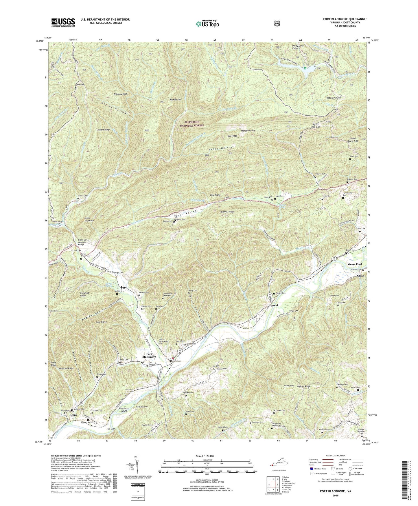
Fort Blackmore Virginia US Topo Map
Couldn't load pickup availability
Also explore the Fort Blackmore Forest Service Topo of this same quad for updated USFS data
2022 topographic map quadrangle Fort Blackmore in the state of Virginia. Scale: 1:24000. Based on the newly updated USGS 7.5' US Topo map series, this map is in the following counties: Scott. The map contains contour data, water features, and other items you are used to seeing on USGS maps, but also has updated roads and other features. This is the next generation of topographic maps. Printed on high-quality waterproof paper with UV fade-resistant inks.
Quads adjacent to this one:
West: East Stone Gap
Northwest: Norton
North: Wise
Northeast: Coeburn
East: Dungannon
Southeast: Hiltons
South: Gate City
Southwest: Clinchport
This map covers the same area as the classic USGS quad with code o36082g5.
Contains the following named places: Back Valley, Bagley Cemetery, Baldwin Cemetery, Baldwin Hollow, Ballard Gillenwater Cemetery, Banner Cemetery, Bark Camp Dam, Bark Camp Lake, Bark Campground, Beard Cemetery, Bearpen Branch, Begley Hollow, Big Branch, Board Tree Gap, Boatright Cemetery, Brickey Cemetery, Brickey Spring, Buckner Ridge, Buckner Ridge Lookout Tower, Buffalo School, Carter Cemetery, Carter Chapel, Carter Chapel Cemetery, Cassells Chapel, Chimney Rock, Chimney Rock Fork, Christ the King Mission, Coalpit Branch, Coalpit Ridge, Compton Cemetery, Corder Cemetery, Cornett Branch, Cox Cemetery, Cub Creek, Davey Land Branch, Davidson Cemetery, Dingus Branch, Dingus Cemetery, District 5, Duncan Cemetery, Flanary Cemetery, Ford Branch, Fort Blackmore, Fort Blackmore Cemetery, Fort Blackmore Methodist Church, Fort Blackmore Post Office, Fort Blackmore Primary School, Fort Blackmore Volunteer Fire Department, Fraysier Cemetery, Frazier Cemetery, George McConnell Cemetery, Gillenwater Family Cemetery, Glady Fork, Glenn Carter Memorial Bridge, Gray Branch, Gray Cemetery, Grays, Grays Ford, Grays Island, Grays School, Greear Cemetery, Greens Chapel, Greer Cemetery, Hagan Cemetery, Hagan Hall, Hagan Spring Branch, Henderson-Cox Cemetery, Hickerson Branch, Horne Cemetery, Hunneycutt Cemetery, Indian Grave Gap, Ivy Patch Branch, Joel Branch, John Gay Branch, John Wesley Lane Cemetery, Johnson Cemetery, Ka, Kendrick Cemetery, Kerns, Kerns Cemetery, Kerns Hollow, Lane Hollow, Lane Ridge, Laney Cemetery, Lano, Lick Creek, Lick Creek Church, Lick Creek School, Low Place Branch, Mahogany Gap, Mahogany Spring Branch, Mann Cemetery, Maple Spring Branch, McConnell Cemetery, McGhee Creek, Middle Ridge, Mill Creek, Moore Cemetery, Moore Hollow, Moping Hollow, Negro Hollow, New Buffalo Church, Osborne Cemetery, Osborne Ridge, Pendleton Cemetery, Pendleton Island, Peters Cemetery, Pierson Cemetery, Pine Grove Church, Pine Grove School, Pine Ridge, Quillen Cemetery, Quillen Hollow, Quillin Cemetery, Redmond Ridge, Riner Cemetery, Rocky Branch, Sluss Cemetery, Stacy Branch, Stallard Cemetery, Staunton Creek, Stony Creek, Straight Fork, Suck Branch, Sulphur Spring, The Suck, Valaho, Valley Creek, Valley View Church, Wood, Young Cemetery, ZIP Codes: 24245, 24250