MyTopo
Exmore Virginia US Topo Map
Couldn't load pickup availability
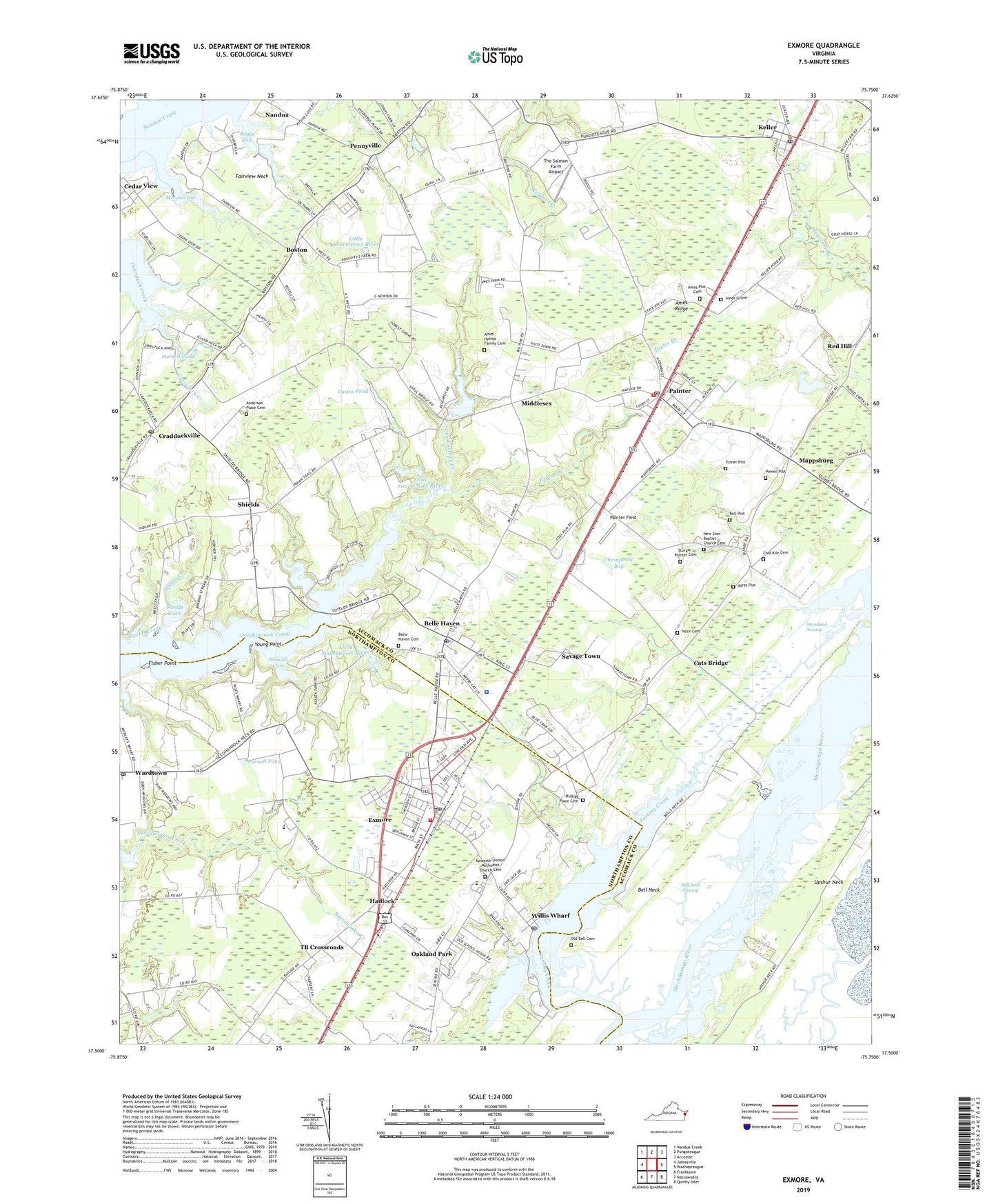
2022 topographic map quadrangle Exmore in the state of Virginia. Scale: 1:24000. Based on the newly updated USGS 7.5' US Topo map series, this map is in the following counties: Accomack, Northampton. The map contains contour data, water features, and other items you are used to seeing on USGS maps, but also has updated roads and other features. This is the next generation of topographic maps. Printed on high-quality waterproof paper with UV fade-resistant inks.
Quads adjacent to this one:
West: Jamesville
Northwest: Nandua Creek
North: Pungoteague
Northeast: Accomac
East: Wachapreague
Southeast: Quinby Inlet
South: Nassawadox
Southwest: Franktown
This map covers the same area as the classic USGS quad with code o37075e7.
Contains the following named places: Ames - Hyslop Family Cemetery, Ames Grave, Ames Plot Cemetery, Ames Ridge, Anderson Place Cemetery, Ayres Plot, Bacon Hill, Bell Neck, Bell Neck Swamp, Belle Haven, Belle Haven Cemetery, Belle Haven Post Office, Belle Haven Station, Boggs Gut, Boston, Boston Census Designated Place, Broadwater Academy, Bull Plot, Cats Bridge, Cats Bridge Census Designated Place, Central Middle School, Coal Kiln, Coal Kiln Cemetery, Coal Kiln Crossing, Community Fire Company, Craddockville, Craddockville Church, Craddockville Post Office, Custis Dam, Custis Pond, District 8, Duer Dam, Duer Pond, Ebenezer Church, Epworth Church, Epworth United Methodist Church Cemetery, Exmore, Exmore Baptist Church, Exmore Police Department, Exmore Post Office, Exmore Wesleyan School, Exmore-Willis Wharf Elementary School, Fairview Neck, Fisher Point, Hadlock, Hare Valley Elementary School, Highland Heights, Holy Trinity Church, Keller, Keller Post Office, Mappsburg, Mappsburg Census Designated Place, McLean Gut, Middlesex, Miles Wharf, Moreland Swamp, Mount Calvary Church, Mount Zion, Mount Zion Church, Nandua, New Zion Baptist Church Cemetery, Nock Cemetery, Northampton Shopping Center, Oakland Park, Occohannock Elementary School, Old Bell Cemetery, Painter, Painter Field, Painter Post Office, Painter Volunteer Fire Department, Parting Creek, Pennyville, Phillips Place Cemetery, Powell Plot, Red Hill, Rue Wharf, Saint Josephs Church, Savage Town, Savage Town Census Designated Place, Sheilds Wharf, Shields, Shields Cove, Shields Creek, Shiloh Church, Sneads Church, Sturgis - Painter Cemetery, Taylor Branch, TB Crossroads, The Salmon Farm Airport, Town of Belle Haven, Town of Exmore, Town of Keller, Town of Painter, Turner Plot, Upshur Neck, Virginia Marine Police - Eastern Shore Office, Virginia Tech - Virginia Cooperative Extension, Virginia Truck and Experimental Station Dam, Virginia Truck and Experimental Station Reservoir, Virginia Truck Experimental Station, Wardtown Post Office, Wescott Cove, Willis Wharf, Willis Wharf Census Designated Place, Willis Wharf Post Office, WPHG-FM (Exmore), Young Point, ZIP Codes: 23306, 23350, 23420, 23486