MyTopo
Pungoteague Virginia US Topo Map
Couldn't load pickup availability
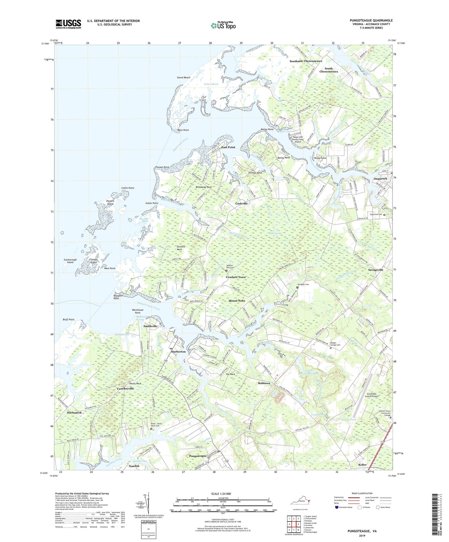
2022 topographic map quadrangle Pungoteague in the state of Virginia. Scale: 1:24000. Based on the newly updated USGS 7.5' US Topo map series, this map is in the following counties: Accomack. The map contains contour data, water features, and other items you are used to seeing on USGS maps, but also has updated roads and other features. This is the next generation of topographic maps. Printed on high-quality waterproof paper with UV fade-resistant inks.
Quads adjacent to this one:
West: Nandua Creek
Northwest: Tangier Island
North: Chesconessex
Northeast: Parksley
East: Accomac
Southeast: Wachapreague
South: Exmore
Southwest: Jamesville
This map covers the same area as the classic USGS quad with code o37075f7.
Contains the following named places: Accomack County Airport, Accomack County Bobtown Southern Landfill, Addison Plot Cemetery, Ames - Hacks Neck Cemetery, Andrew Chapel, Arlington Cemetery, Back Creek, Badger - Savage Cemetery, Bailey Neck, Bailey Point, Bluff Point, Bobtown, Bobtown Census Designated Place, Bobtown Nursery, Boggs Wharf, Broadway Church, Broadway Landing, Broadway Neck, Buckland Gut, Bull Branch, Cashville, Cedar Creek, Central Branch Onancock Creek, Chandler Marsh, Coffin Point, Coocheyville, Crockett Town, Dahl Swamp, Dinglers Mill, East Point, Eastern Shore Community College, Eastern Shore Community College Police Department, Eastern Shore Regional Fire Training Center, Eastern Shore Yacht and Country Club, Evans Wharf, Evergreen Church, Finneys Creek, Finneys Island, Finneys Neck, Finneys Wharf, Gaskin Chapel, Gospel Temple Church, Hacks Neck, Hacksneck, Hancock Gut, Harborton, Harborton Census Designated Place, Harborton Post Office, Harborton Solid Waste Receiving Facility, Hollies Church, Hollies Church Branch, Horse Hole Creek, Indian Point, Klondike Point, Kusian Cove, Leatherberry Creek, Little Hell, Locksville, Matchotank Creek, Moore Branch, Mount Nebo, Mount Olive Church, North Branch Onancock Creek, Onancock Cemetery, Onancock Creek, Onancock Post Office, Onley Point, Pakers Creek, Parkers Island, Parkers Marsh, Peace and Plenty Farm Airport, Pine Ridge Mobile Home Park, Poplar Cove, Poplar Cove Wharf, Pungoteague, Pungoteague Census Designated Place, Pungoteague Creek, Pungoteague Elementary School, Pungoteague Post Office, Saint Georges Church, Savageville, Savageville Census Designated Place, Scarborough Island, Scott Store, Sluitkill Neck, Smithville, Sound Beach, South Branch Onancock Creek, South Chesconessex, Southside Chesconessex Census Designated Place, Tankard Dam, Tankard Pond, Tarkill Creek, Taylor Creek, Thicket Creek, Thicket Point, Titlow Creek, Underhill Creek, Ware Point, Warehouse Point, Warehouse Prong, West Point, Yeo Neck, ZIP Codes: 23358, 23389, 23401, 23422