MyTopo
Fredericksburg Virginia US Topo Map
Couldn't load pickup availability
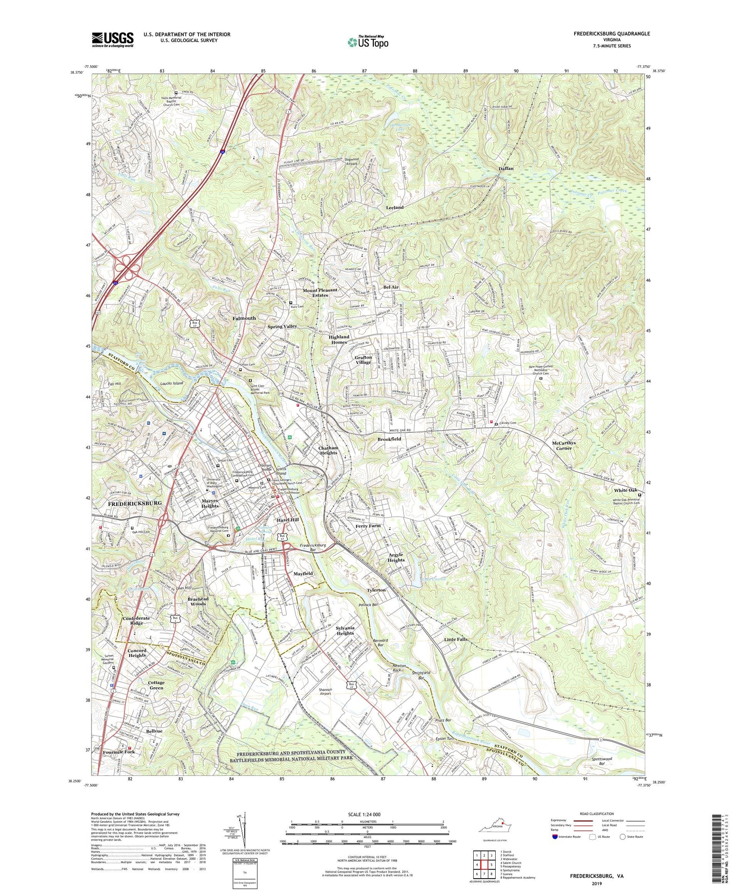
2022 topographic map quadrangle Fredericksburg in the state of Virginia. Scale: 1:24000. Based on the newly updated USGS 7.5' US Topo map series, this map is in the following counties: Stafford, Spotsylvania, Fredericksburg (city). The map contains contour data, water features, and other items you are used to seeing on USGS maps, but also has updated roads and other features. This is the next generation of topographic maps. Printed on high-quality waterproof paper with UV fade-resistant inks.
Quads adjacent to this one:
West: Salem Church
Northwest: Storck
North: Stafford
Northeast: Widewater
East: Passapatanzy
Southeast: Rappahannock Academy
South: Guinea
Southwest: Spotsylvania
This map covers the same area as the classic USGS quad with code o38077c4.
Contains the following named places: Alum Springs Park, Amaret Shopping Center, Argyle Heights, Argyle Hills, Argyle Terrace, Artillery Ridge, Basil Gordon, Battlefield Industrial Park, Bel Air, Bel Plains Estates, Belle Air Heights, Belle Oaks, Bellvue, Belmont, Belmont Hills, Bermard Bar, Bexley Manor, Blythedale, Boscobel, Boscobel Woods, Bourne, Braehead Woods, Briarwood Estates, Bridle Lake Estates, Brookewood Estates, Brookewood Farms, Brookfield, Brookfield Hills, Brooks, Brookstone, Burnside, Butterfield, Cannon Ridge, Cedar Bluff, Chapel View, Charlestown Commons, Chatam, Chatam Square Office Park, Chatham Farms, Chatham Heights, Chatham Landing, Chatham Shopping Center, Chatham Village, City Dock Park, City of Fredericksburg, City of Fredericksburg Wastewater Treatment Facility, Claiborne Run, Clarion Woods, Clearview, Clearview Heights, Colonial Heights, Concord Heights, Confederate Ridge, Cottage Green, Cranes Corner, Cranewood, Daffan, Dahlgren Junction, Deacon Road Estates, Deacon Woods, Debruyn, Deep Run, Deer Forest, Dogwood Airpark, Duff McDuff Green Memorial Park, Earls Shopping Center, East Argyle Heights, East Chatham Heights, Embrey Dam, Embrey Industrial Park, England Run North, Epson Turn, Fairview and Oakland, Fall Hill, Fall Quarry Run, Fall Run Park, Falls Run, Falls Run Industrial Park, Falmouth, Falmouth Beach Park, Falmouth Bridge, Falmouth Census Designated Place, Falmouth District, Falmouth Heights, Falmouth Historic District, Falmouth Village, Ferry Farm, Ferry Road, Fitzhugh, Fourmile Fork, Fredericksburg, Fredericksburg Agricultural Fairgrounds, Fredericksburg Bar, Fredericksburg Battlefield, Fredericksburg Confederate Cemetery, Fredericksburg Country Club, Fredericksburg Park and Shop Shopping Center, Fredericksburg Sand and Gravel Pit, Fredericksburg Shopping Center, General Mercer Monument, George Rogers Clark Monument, George Washington District, George Washingtons Ferry Farm, Gordon and Keziah Sullivan Estates, Grafton Village, Grandview, Graninger, Graninger Mobile Home Park, Greenbrier Shopping Center, Greenstreet Mobile Home Park, Hamlin Hills, Hampstead Village, Hart Division of Little Falls, Hazel Hill, Hazel Run, Heather Hills, Henderson Dam, Henderson Lake, Heritage Commons, Hickory Ridge, High School Heights, Highland Homes, Hillcrest Terrace, Holly Ridge, Hoyt, Huntington Hills, Hurkamp Park, Ingleside, Interstate Business Park, Jefferson Place, John Lee Pratt Memorial Park, John W. Warner Rapids, Joseph Sullivan Estates, Kendallwood East, Kendallwood Estates, Kenmore Park, Kennedy Dam, Kurz Cemetery, Lake Carroll, Lansberry Park, Laucks Island, Lee Hill Industrial Park, Lee Plaza Shopping Center, Leeland, Leeland Creek Estates, Leeland Heights, Leeland Station, Lees Hill, Light Oak Glen, Little Creek, Little Falls, Little Falls Boat Landing, Little Falls Run, Little Falls Village, Locust Knolls, Long Branch, Lynwood, Mary Washington Athletic Field, Maryes Heights, Massaponax Creek, Mayfield, McCarthys Corner, Meade Pyramid, Melchers Complex, Michaelbrooke Estates, Misty Forest, Moreland, Mount Pleasant Estates, Mount Ringold Farm, New Hope Estates, Newton Rock, North Clearview Heights, North Ferry Farms, North Potomac, Northridge, O Bannon Land, Oak Ridge, Oakland and Fairview, Old Mill Historic District, Old Mill Park, Olde Forge, Olde Forge Shopping Center, Olde Greenwich Shopping Center, Park and Shop Shopping Center, Part Little Falls, Phillips, Pollock Bar, Potomac, Potomac Run Farm, Pratt Bar, Pratt Park, Richard Kirkland Monument, Ridge Pointe, River Club Center Shopping Center, River Heights, River Road Park, Saint Clair Brooks Memorial Park, Scotts Island, Shannon Airport, Smithfield Bar, Spotsylvania County Industrial Park, Spottswood Bar, Spring Valley, Stones Corner, Stratford Place, Sullivan, Sunnyside Division, Sunset Memorial Gardens, Sweetbriar Woods, Sylvania Heights, The Hills of Potomac Creek, The Hills of Stafford, The Oaks at Ferry Farm, Thomas Jefferson Religious Freedom Monument, Towns of East Chatham Heights, Travellers Rest, Twin Lakes, Tylerton, Upper Redoubt Heights, Victoria Woods, Village Plaza Shopping Center, Walnut Hill, Walter Roberson Estate, Waltlou Mobile Home Park, Wellford Sullivan Estate, Westwood Office Park, Westwood Shopping Center, White Oak, White Oak Hills, Wildcat Corner, Will-More, Woodland, Woodlawn, ZIP Codes: 22401, 22405