MyTopo
Stafford Virginia US Topo Map
Couldn't load pickup availability
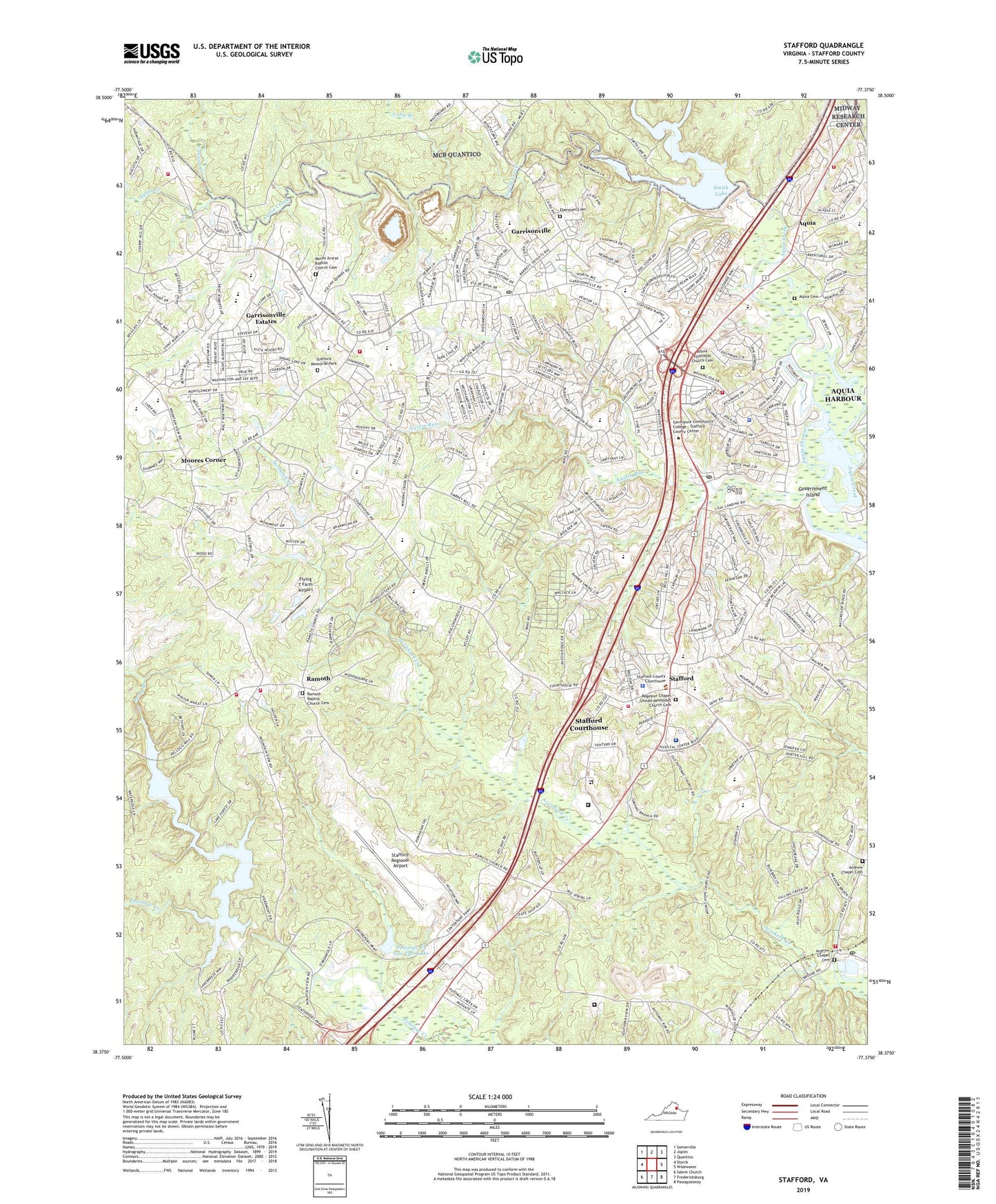
2022 topographic map quadrangle Stafford in the state of Virginia. Scale: 1:24000. Based on the newly updated USGS 7.5' US Topo map series, this map is in the following counties: Stafford. The map contains contour data, water features, and other items you are used to seeing on USGS maps, but also has updated roads and other features. This is the next generation of topographic maps. Printed on high-quality waterproof paper with UV fade-resistant inks.
Quads adjacent to this one:
West: Storck
Northwest: Somerville
North: Joplin
Northeast: Quantico
East: Widewater
Southeast: Passapatanzy
South: Fredericksburg
Southwest: Salem Church
This map covers the same area as the classic USGS quad with code o38077d4.
Contains the following named places: A G Wright Middle School, Abel Lake, Abel Lake Forest, Abel Reservoir Boat Landing, Andrew Chapel Cemetery, Anne E Moncure Elementary School, Anthony Burns Elementary School, Apple Grove, Aquia, Aquia Cemetery, Aquia Channel, Aquia Creek, Aquia Creek Dam, Aquia Episcopal Church Cemetery, Aquia Harbor Police, Aquia Harbor Volunteer Rescue Squad Company Number 9, Aquia Harbour, Aquia Harbour Census Designated Place, Aquia Harbour Golf Course, Aquia Harbour Marina, Aquia Pines Campground, Aquia Professional Village, Aquia Regional Wastewater Facility, Aquia Wastewater Treatment Plant, Arbor Glen, Armstrong Tract School, Augustine Golf Course, Augustine North, Austin Ridge, Austin Ridge Elementary School, Austin Ridge Park, Austin Run, Autumn Ridge, Autumn Ridge Park, Azalea Woods, Bald Eagle Hills, Barrett Heights, Barrett Knolls, Beau Ridge, Beaverdam Run, Bells Run, Beverly Forest, Bowers, Brafferton, Brafferton Shopping Center, Brentwood Estates, Brooke, Brooke Point High School, Brooke Post Office, Brookwood Nursing Home, Cabin Creekwood, Camp Barrett, Cannon Creek, Canterbury Village, Cherry Hill Estates, Coal Landing, Cobblestone, Colonial Academy, Colonial Forge High School, Colonial Terrace, Country Ridge, Courthouse Square at Stafford, Courts at Stafford, Cresent Pointe, Crucifix Monument, Devon Green, Dittmeier, Docstone Commons, Docstone Woods, Eastern View, Ebenezer Cemetery, Elizabeth Park, Embrey Mill Elementary School, Estates of Brooke, Flying T Farm Airport, Foreston Woods North, Fritters Lane, Garrisonville, Garrisonville District, Garrisonville Elementary School, Garrisonville Estates, Garrisonville Post Office, Georgetown East, Glenwood Forest, Government Island, Grace Preparatory School, Grays Steven Tract, Greenridge, Groves Estates, H H Poole Middle School, Hallbrooke Woods, Hampton Oaks, Hampton Oaks Elementary School, Heritage Oaks, Highpointe, Hollymead, Hunter Trail at Stafford, J A Macgregor Estate, Kate Waller Barrett Elementary School, King James Village, Kings Crest, Lake Ridge and Bethany Pointe, Liberty Place, LifeEvac II, Locklears Knoll, Locklears Landing, Long Branch, Magnolia Woods, Manors at Greenridge, Margaret Brent Elementary School, Marine Corps Base Quantico, Marshall Estates, Meadowbrook Estates, Meadowlark, Meadowood Park, Meadowood Village, Minnieland Academy, Moores Corner, Mount Ararat Baptist Church Cemetery, Mountain View, Mountain View High School, Mountain View Volunteer Rescue Squad Company Number 4, North Stafford High School, North Stafford Industrial Park, North Stafford Public Library, Oakbrooke, Oakridge Overlook, Oakridge Pointe, Old Homestead, Onville, Park Ridge, Park Ridge Athletic Fields, Park Ridge Elementary School, Patriots Landing, Peacock Station, Penny Industrial Park, Peppermint Forest, Perry Farms, Pool School, Port Aquia, Port Aquia Commercial Center, Potomac Creek Number One Dam, Potomac Creek Number Two Dam, Potomac Creek Site Two Lake, Potomac Hills, Potomac Industrial Park, Quail Run, Raintree, Ramoth, Ramoth Baptist Church Cemetery, Ramoth Church Estates, Rappahannock Juvenile Detention Home School, Regester Chapel United Methodist Church Cemetery, Rockhill Elementary School, Rodney Thompson Middle School, Rolling Meadows, Rollinswood South, Saint Georges, Saint Georges Estates, Saint William of York Catholic School, Serena Forest, Settlers Landing, Shadow Woods, Shawnee Forest, Sheltons Run, Sheltons Shop, Shenandoah, Sky Terrace, Skywoods, Smith Lake, Smith Lake Estates, Smith Lake Landing, Smith Lake Overlook, Smith Lake Park, Somerset Landing, Spring Lake Farm, Stafford, Stafford County, Stafford County Fire and Rescue Department Emergency Medical Services Station 1 Stafford, Stafford County Fire and Rescue Department Emergency Medical Services Station 4 Mountain View, Stafford County Fire and Rescue Department Emergency Medical Services Station 8 Rockhill, Stafford County Fire and Rescue Department Fire Marshal's Office, Stafford County Fire and Rescue Department Station 10 Potomac Hills, Stafford County Fire and Rescue Department Station 2 Stafford, Stafford County Fire and Rescue Department Station 4 Mountain View, Stafford County Fire and Rescue Department Station 5 Brooke, Stafford County Fire and Rescue Department Station 9 Aquia Harbour, Stafford County Sheriff's Office, Stafford Courthouse Census Designated Place, Stafford Elementary School, Stafford Greens, Stafford Heights, Stafford Hospital, Stafford Market Place, Stafford Memorial Park, Stafford Mews, Stafford Middle School, Stafford Oaks, Stafford Post Office, Stafford Quarry, Stafford Regional Airport, Stafford Square, Stafford Volunteer Rescue Squad Rescue 1, Stafford Wayside, Staffordborough, Stallings, Stefin Woods Estate, Stone River, Stonefield, Stonehill Estates, Stowe of Amyclae, Summerwind, Summerwood, Sunnyside, Tamarlane, Taylor Bott Industrial Park, The Columns, The Falls, Townes of Ashleigh, Twin Oaks, Vestavia Woods, Vintage Oaks, Virginia Department of Correctional Education - Stafford Diversion Center, Vista Woods, Wayside, Whitson Ridge, Whitson Run, Widewater Village at Stafford, Will Morgan Farm, Winding Creek Elementary School, Woodleigh, Woodmont, Woods of Able Lake, WRFS-AM (Garrisonville), Youngstead