MyTopo
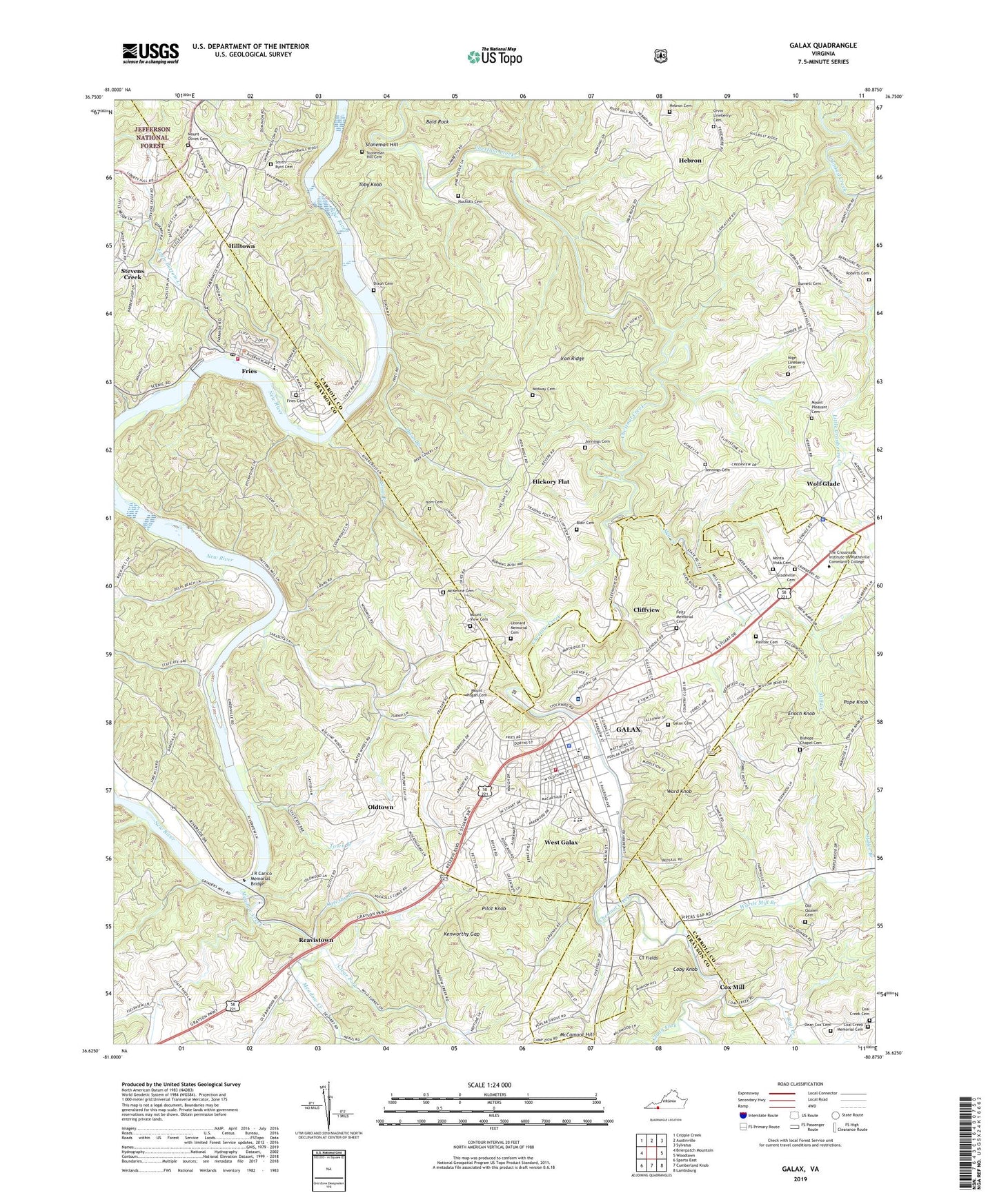
Galax Virginia US Topo Map
Couldn't load pickup availability
Also explore the Galax Forest Service Topo of this same quad for updated USFS data
2022 topographic map quadrangle Galax in the state of Virginia. Scale: 1:24000. Based on the newly updated USGS 7.5' US Topo map series, this map is in the following counties: Carroll, Grayson, Galax (city). The map contains contour data, water features, and other items you are used to seeing on USGS maps, but also has updated roads and other features. This is the next generation of topographic maps. Printed on high-quality waterproof paper with UV fade-resistant inks.
Quads adjacent to this one:
West: Brierpatch Mountain
Northwest: Cripple Creek
North: Austinville
Northeast: Sylvatus
East: Woodlawn
Southeast: Lambsburg
South: Cumberland Knob
Southwest: Sparta East
This map covers the same area as the classic USGS quad with code o36080f8.
Contains the following named places: Austin School, Bald Rock, Ballard Cemetery, Beulah Church, Bishop School, Bishops Chapel, Bishops Chapel Cemetery, Blair Cemetery, Blair Ferry, Burnett Cemetery, Calvary Church, Camp Zion Church, Chestnut Yard, Church of the Good Shepherd, City of Galax, Clear Fork, Cliffview, Cliffview Church, Coal Creek, Coal Creek Church, Coal Creek Memorial Cemetery, Coal Creek School, Coby Knob, Cooperative Center for Exceptional Children, Cox Mill, CT Fields, Daniel Branch, Dean Cox Cemetery, Dickinson Ferry, Dixon Branch, Dixon Cemetery, Eagle Bottom Creek, Enoch Knob, Faith Temple, Farmville School, Felts Junior High School, Felts Memorial Cemetery, Felts Park, First Christian Church, Fries, Fries Cemetery, Fries Church, Fries Middle School, Fries Mill Dam, Fries Post Office, Fries Tabernacle, Fries Volunteer Fire and Rescue Squad, Galax, Galax - Grayson Emergency Medical Services, Galax Cemetery, Galax Church, Galax Elementary School, Galax High School, Galax Middle School, Galax Police Department, Galax Post Office, Galax Volunteer Fire Department, Gladeville Cemetery, Gladeville Church, Gladeville Elementary School, Glady Fork, Glenwood Church, Grace Church, Hebron, Hebron Cemetery, Hebron Church of Christ, Hickory Flat, Hilltown, Hilltown Census Designated Place, Iron Ridge, Isom Cemetery, J R Carico Memorial Bridge, Jennings Cemetery, Kenworthy Gap, Leonard Church, Leonard Memorial Cemetery, Life Center of Galax, Locust Grove School, McCamant Hill, McKenzie Cemetery, Meadow Creek, Midway Cemetery, Midway Church, Mill Creek, Miller Branch, Monta Vista Cemetery, Mount Ararat Church, Mount Olivet Church, Mount Olivet United Methodist Church Cemetery, Mount Pisgah Church, Mount Pisgah School, Mount Pleasant Cemetery, Mount Sinai Church, Mount Vernon School, Mount View Cemetery, Mount View Church, Nige Lineberry Cemetery, Nuckolls Cemetery, Oak Hill School, Oglesby Branch, Old Quaker Cemetery, Oldtown, Orvin Lineberry Cemetery, Painter Cemetery, Pilot Knob, Pinegrove School, Pope Knob, Poplar Grove School, Quaker Church, Reavistown, Redman Branch, Roberts Cemetery, Smith - Byrd Cemetery, Stevens Creek, Stevens Creek Census Designated Place, Stoneman Hill, Stoneman Hill Cemetery, Stout Branch, Toby Knob, Town Branch, Town of Fries, Twin County Plaza Shopping Center, Twin County Regional Hospital, Union Church, Vaughan School, Virginia State Police Division 4 Area 25 Office, Ward Knob, Wards Mill Branch, WBOB-AM (Galax), West Galax, West Galax Methodist Church, Whiteoak Grove School, Wolf Glade, WPRH-FM (Galax), ZIP Code: 24333