MyTopo
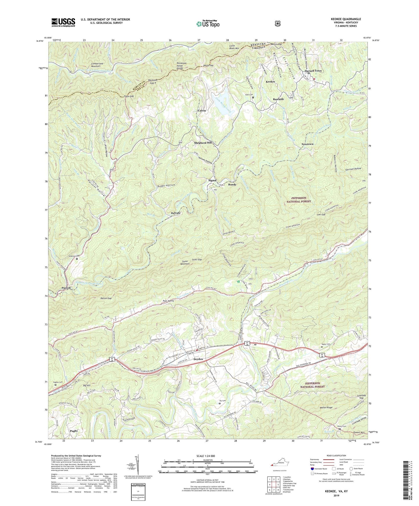
Keokee Virginia US Topo Map
Couldn't load pickup availability
Also explore the Keokee Forest Service Topo of this same quad for updated USFS data
2022 topographic map quadrangle Keokee in the states of Virginia, Kentucky. Scale: 1:24000. Based on the newly updated USGS 7.5' US Topo map series, this map is in the following counties: Lee, Harlan. The map contains contour data, water features, and other items you are used to seeing on USGS maps, but also has updated roads and other features. This is the next generation of topographic maps. Printed on high-quality waterproof paper with UV fade-resistant inks.
Quads adjacent to this one:
West: Pennington Gap
Northwest: Louellen
North: Benham
Northeast: Appalachia
East: Big Stone Gap
Southeast: Duffield
South: Stickleyville
Southwest: Ben Hur
This map covers the same area as the classic USGS quad with code o36082g8.
Contains the following named places: Allen Hollow, Anderson Cemetery, Baker Cemetery, Bear Branch, Big Hill, Big Stone Gap 6, Boggs Hollow, Buckles, Bundy, Bundy Creek, Calvary Church, Calvin, Camp Creek, Carroll Hollow, Cave Springs Campground, Clear Spring Branch, Colliers Cove, Cox Creek, Craborchard Creek, Craft Hollow, Dalton Gap, Darnell Town, Darty Gap, De Busk Ford, Delvale, District 4, District 5, Dry School, Dryden, Dryden Census Designated Place, Dryden Elementary School, Dryden Post Office, Dryden Volunteer Fire Department, Eden Cemetery, Ely, Ely Cemetery, Ely Creek, Ely Memorial Church, Flanary Branch, Garrison Hollow, Green Hill Church, Green Hill School, Haupts Branch, Heads Creek, Holmes Hollow, Holmes House, Holmes School, Hoover Chapel, Huff Creek, Hughes Cemetery, Jack Bailey Branch, Johnsons Mill, Jones Creek, Jordon Branch, Keokee, Keokee Census Designated Place, Keokee Elementary School, Keokee Post Office, Keokee Volunteer Fire Rescue, Keokee Volunteer Rescue Squad, Laurel Branch, Lick Branch, Little Bundy Creek, Lovelady Gap, Low Gap, Low Gap Branch, Lower Trace Branch, Marcum Branch, Marcum Hollow, McConnell Branch, McConnell Hollow, Meadow Branch, Med Short Branch, Mill Branch, Mohawk, Mohawk School, Moore Branch, Morris Gap, Mud Creek, Newtown, Olinger Lookout Tower, Parsons Hollow, Payne Branch, Peters Cemetery, Poor Valley Creek, Pughs, Purcell, Rawhide, Reeds Creek, Right Fork Jones Creek, Right Fork Mud Creek, Robbins, Robbins Chapel, Robbins Chapel School, Roberts Hollow, Scott Gap, Shepherd Hill, Sigma, Stallard Ford, Stone Mountain Wilderness, Trace Gap, Valley View Church, Wells Branch, Whisman Hollow, Willis Chapel, Yokum Station District, ZIP Codes: 24243, 24265