MyTopo
Lebanon Virginia US Topo Map
Couldn't load pickup availability
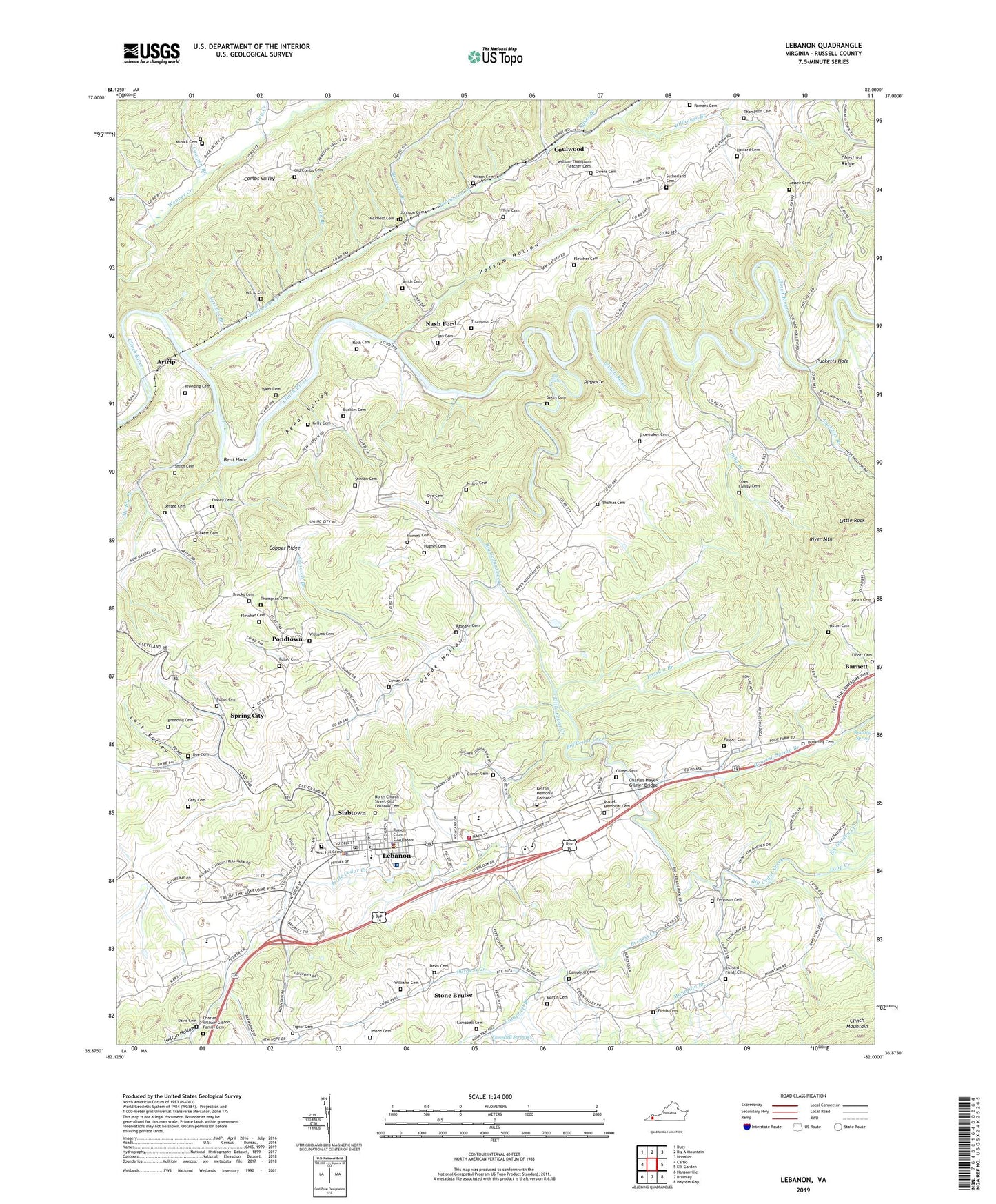
2022 topographic map quadrangle Lebanon in the state of Virginia. Scale: 1:24000. Based on the newly updated USGS 7.5' US Topo map series, this map is in the following counties: Russell. The map contains contour data, water features, and other items you are used to seeing on USGS maps, but also has updated roads and other features. This is the next generation of topographic maps. Printed on high-quality waterproof paper with UV fade-resistant inks.
Quads adjacent to this one:
West: Carbo
Northwest: Duty
North: Big A Mountain
Northeast: Honaker
East: Elk Garden
Southeast: Hayters Gap
South: Brumley
Southwest: Hansonville
This map covers the same area as the classic USGS quad with code o36082h1.
Contains the following named places: Alvy Creek, Artrip, Artrip Cemetery, Balltown Branch, Barnett, Bascom Church, Bent Hole, Big Cedar Creek, Big Cedar Mill, Big Falls, Breeding Cemetery, Breezers Branch, Brooks Cemetery, Browning Cemetery, Buckles Cemetery, Burgess Creek, Campbell Branch, Campbell Cemetery, Campbell Springs, Cedar Creek Mission, Cedar Creek Park, Charles Hayes Gilmer Bridge, Charles William Gibson Family Cemetery, Clinchfield Heliport, Combs Valley, Concord Church, Cooper Ridge School, Copper Ridge Church, Corner, Corner School, Coulwood, Cowan Cemetery, Cowpen Branch, Cumberland Plateau Regional Industrial Park, Davis Cemetery, Dilly Branch, Dye Cemetery, Elk Garden Creek, Elliott Cemetery, Ferguson Cemetery, Fields Cemetery, Fife Cemetery, Finney Cemetery, Fletcher Cemetery, Fuller Cemetery, Fullers, Gilmer Cemetery, Glade Hollow, Gray Cemetery, Grizzles Branch, Helton Cemetery, Helton Hollow, Howard Cemetery, Hughes Cemetery, Jessee Cemetery, Johnson Cemetery, Kelly Cemetery, Ketron Memorial Gardens, Lebanon, Lebanon District, Lebanon Elementary School, Lebanon High School, Lebanon Lifesaving Crew, Lebanon Middle School, Lebanon Police Department, Lebanon Post Office, Lebanon Primary School, Lebanon Town Hall, Lebanon Volunteer Fire Department, Lick Branch, Little Cedar Creek, Little Rock, Loop Creek, Lost Valley, Martin Cemetery, Maxfield Cemetery, Mercy Ambulance Service, Miller View Church, Mount Olive Church, Mountain Branch, Muddy Branch, Munsey Cemetery, Musick Cemetery, Musick School, Nash Cemetery, Nash Ford, New Gardner Church, North Church Street-Old Lebanon Cemetery, Oak Grove Baptist Church, Old Combs Cemetery, Owens Cemetery, Pauper Cemetery, Pinnacle, Pondtown, Possum Branch, Possum Hollow, Puckett Cemetery, Pucketts Branch, Pucketts Hole, Rasnake Cemetery, Ray Cemetery, Reeds Valley, Reeds Valley Church, Richard Fields Cemetery, Roaring Spring, Roaring Spring Branch, Romans Cemetery, Russell County, Russell County Career and Technology Center, Russell County Courthouse, Russell County Industrial Park, Russell County Library, Russell County Medical Center, Russell County Sheriff's Office, Russell Memorial Cemetery, Shoemaker Cemetery, Slabtown, Smith Cemetery, Smootch Branch, Spring City, Spring City Baptist Church, Spring City Baptist School, Stillhouse Branch, Stinson Cemetery, Stone Bruise, Sutherland Cemetery, Sykes Branch, Sykes Cemetery, Thomas Cemetery, Thompson Cemetery, Thompson Creek, Tignor Cemetery, Town of Lebanon, Weaver Creek, Weaver Creek School, West Hill Cemetery, William Thompson Fletcher Cemetery, Williams Cemetery, Wilson Cemetery, WLRV-AM (Lebanon), Yates Family Cemetery