MyTopo
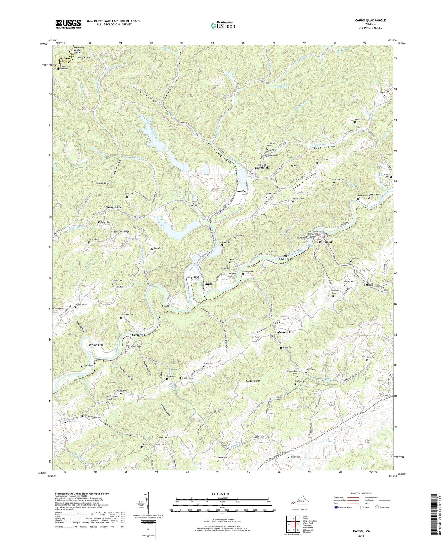
Carbo Virginia US Topo Map
Couldn't load pickup availability
2022 topographic map quadrangle Carbo in the state of Virginia. Scale: 1:24000. Based on the newly updated USGS 7.5' US Topo map series, this map is in the following counties: Russell, Dickenson. The map contains contour data, water features, and other items you are used to seeing on USGS maps, but also has updated roads and other features. This is the next generation of topographic maps. Printed on high-quality waterproof paper with UV fade-resistant inks.
Quads adjacent to this one:
West: Saint Paul
Northwest: Nora
North: Duty
Northeast: Big A Mountain
East: Lebanon
Southeast: Brumley
South: Hansonville
Southwest: Moll Creek
This map covers the same area as the classic USGS quad with code o36082h2.
Contains the following named places: Abby Counts Island, Anderson Creek, Aranco-Kiser Cemetery, Artrip Cemetery, Ash Pond Area Number One, Ash Pond Number Two, Ashbrook Cemetery, Back Valley, Bee Branch, Blankenship Cemetery, Brushy Ridge, Burke Cemetery, Candler, Candler Cemetery, Carbo, Carter Cemetery, Carterton, Castlewood District, Chafin Cemetery, Chaney Creek, Chaney Fork School, Chaney Hollow, Clark Cemetery, Cleveland, Cleveland Elementary School, Cleveland Lifesaving Crew, Cleveland Post Office, Cleveland Volunteer Fire Department, Clinch River Flyash Dike Number One Dam, Clinch River Flyash Dike Number Two Dam, Clinch River Steam Plant, Clinchfield, Couch Cemetery, Counts, Counts Cemetery, Dark Hollow, Davis Cemetery, Dickenson Cemetery, Dickenson Corner, Dorton Hollow, Dry Run, Dry Run Bend, Dumps Creek, Eagle Nest Branch, Evans Cemetery, Glade View Church, Gose Cemetery, Grassy Branch, Gravel Lick, Gravel Lick School, Grizzle, Grizzle Cemetery, Hackney Cemetery, Hazel Mountain Lookout Tower, Honey Branch, Hop Hollow, Huffman Cemetery, Hurricane Fork, Ivy Ridge, Ivy Ridge Church, Jessee Cemetery, Jessee Hollow, Jessees Mill, John Counts Memorial Bridge, Johnson Cemetery, Kiser, Kiser Bend, Kiser Cemetery, Lake Bonaventure, Lake Bonaventure Dam, Laurel Branch, McReynolds Cemetery, Meade Branch, Meade Cemetery, Middle Fork Clinch River, Middle Fork Slurry Impoundment Dam, Mill Creek, Mill Creek Church, Mill Creek School, Millstone Branch, Monk Branch, Moss Number 2 Mine and Preparation Plant, Moss Number 3 Preparation Plant, Moss Number Three Preparation Plant Upper Slurry, Moss Number Two Mine Pond Dam, Muddy Branch, Muddy Hollow, Munseys Chapel, Musick Cemetery, Pennus Hollow, Pleasant Hill Church, Possum Hollow, Purcell, Rasnake Cemetery, Red Oak Ridge, Reeds Valley Church Cemetery, Rocky Fork, Sexton Branch, Sexton Hollow, Sinkhole Valley, Sinking Creek, Skeen Cemetery, Smith Cemetery, South Clinchfield, Springfield Church, Spruce Pine Hollow, Stillhouse Hollow, Stonecoal Creek, Sutherland Cemetery, Tank Hollow, Tank Hollow Falls, Town of Cleveland, Tunnel Hill, Turner Cemetery, Weaver Creek Church, Winney Hollow, Wolfpen Branch, ZIP Code: 24225