MyTopo
Lincoln Virginia US Topo Map
Couldn't load pickup availability
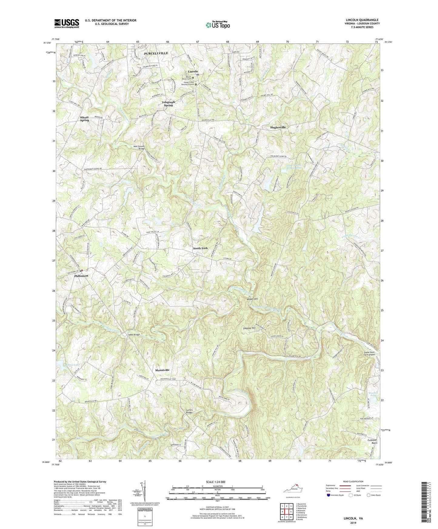
2022 topographic map quadrangle Lincoln in the state of Virginia. Scale: 1:24000. Based on the newly updated USGS 7.5' US Topo map series, this map is in the following counties: Loudoun. The map contains contour data, water features, and other items you are used to seeing on USGS maps, but also has updated roads and other features. This is the next generation of topographic maps. Printed on high-quality waterproof paper with UV fade-resistant inks.
Quads adjacent to this one:
West: Bluemont
North: Purcellville
Northeast: Waterford
East: Leesburg
Southeast: Arcola
South: Middleburg
Southwest: Rectortown
This map covers the same area as the classic USGS quad with code o39077a6.
Contains the following named places: Beaverdam Creek, Bell Dam, Bell Pond, Blue Ridge District, Bronze Hill Farm Dam, Camp Highroad, Carters Bridge, Circleville, Corti-Jencen Dam, Creekspring Court Dam, Crooked Run, Dogwood Farm, Egypt Farm, Flint Hill, Fox Chase, Goose Creek Burying Ground, Goose Creek Historic District, Goose Creek Meeting House, Greggsville, Haynes Dam, Hibbs Bridge, Hibbs Mill, Huber-Mount Gilead Road Dam, Hughesville, Izaak Walton League Dam, Izaak Walton League Pond, Jacks Run, Kingsley Lake, Lawrence Dam, Lincoln, Lincoln Elementary School, Lincoln Post Office, Loudoun County, Loudoun County Agricultural and Chemical Institute, Loudoun County Fire and Rescue Philomont Station 8, Marble Quarry, Marble Quarry School, McGhee Dam, McGhee Lake, Mercer District, Mount Gilead, Mount Olive Baptist Church, Mount Olive Cemetery, Mountville, New Guinea Bridge, New Zion Baptist Church, North Fork, North Fork Goose Creek, NW Arkansas Dam, Oliver Dam, Oliver Lake, Philomont, Philomont Community Center, Philomont Post Office, Reckmeyer Dam, Roszell Chapel United Methodist Church, Silcott Spring, Steptoe Hill, Telegraph Spring, The Quarry Dam, Trammeltown, Vesper Hill, Wancopin Creek, Watermill Road Dam, White Goose Lane Dam, Woodall Dam, Woodall Pond, Woodburn School, Zion Church