MyTopo
Norge Virginia US Topo Map
Couldn't load pickup availability
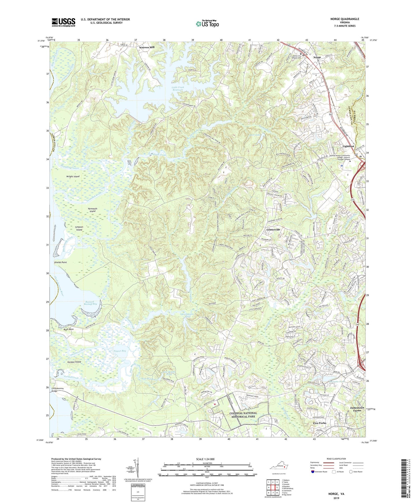
2022 topographic map quadrangle Norge in the state of Virginia. Scale: 1:24000. Based on the newly updated USGS 7.5' US Topo map series, this map is in the following counties: James City, York, Charles City. The map contains contour data, water features, and other items you are used to seeing on USGS maps, but also has updated roads and other features. This is the next generation of topographic maps. Printed on high-quality waterproof paper with UV fade-resistant inks.
Quads adjacent to this one:
West: Brandon
Northwest: Walkers
North: Toano
Northeast: Gressitt
East: Williamsburg
Southeast: Hog Island
South: Surry
Southwest: Claremont
This map covers the same area as the classic USGS quad with code o37076c7.
Contains the following named places: Adams Hunt, Assisted Living at Patriots Colony at Williamsburg, Baron Woods, Bazzard Bay, Black Stump School, Blackstump Creek, Brickbat School, Burton Woods, Bush Neck, Buzzard Bay, Camelot, Camp Chickahominy, Camp Chickahominy Lake, Camp Chickahominy Lake Dam, Centerville, Chestnut Hill, Chickahominy Church, Chisel Run, Christian Life Center, Claybank Landing, Colby Swamp, Colonial Heritage Golf Club, Colonial Towne Plaza Shopping Center, Cranstons Dam, Cranstons Pond, Crosswalk Community Church, D J Montague Elementary School, Deer Lake, Deerwood Hills, Dominion Village of Williamsburg Assisted Living Facility, Eastern State Hospital Reservoir, Farmville Estates, Fieldcrest, Five Forks, Fords Colony, Fords Colony Golf Course, Forest Glen, Fox Ridge, Gallery Shops At Lightfoot Shopping Center, Gordon Island, Governors Green Shopping Center, Green Spring, Green Springs National Historic Landmark District, Greensprings Mobile Home Park, Heath Trailer Park, Heritage Landing, Hog Neck Creek, Hunters Creek, James City Chapel Cemetery, James City County, James City County Fire Department / Ambulance Station 5, James City County Landfill, James City County Police Department, James River Church, James Shire Settlement, Jamestown Church, Jamestown District, Jamestown High School, John Tyler Commercial Park, Jolly Dam, Jolly Pond, Kristiansand, Lafayette High School, Lafayette Square, Lake Toano Estates, Lightfoot, Lightfoot Post Office, Little Creek, Little Creek Dam, Little Creek Reservoir, Little Creek Reservoir Recreation Area, Long Hill Swamp, Longhill Gate, Marstons Mobile Home Park, Matoaka Elementary School, Mid County Park, Middle Plantation, Mobile Estates, Mount Pleasant Church, Nayses Bay, New Zion Church, Norge, Norge Court, Norge Crossing Shopping Center, Norge Elementary School, Norge Post Office, Oakland, Olde Towne Shopping Center, Our Savior Church, Peninsula Scout Reservation, Pine Woods Creek, Pine Woods Pond, Powhatan Crossing, Powhatan District, Powhatan of Williamsburg, Powhatan Plantation, Powhatan Secondary, Providence Classical School, Rennicks Pond, Rennicks Pond Dam, Saint Bedes Catholic Church, Seasons Trace, Shields Point, Shipyard Creek, Shipyard Landing, Simpson Island, Smith Memorial Church, Springhill, Steeple Chase, The Convalescent Center at Patriots Colony, The Foxes, The Links, The Meadows, Toano Trace, Uncles Neck Creek, Warburton Pond, Warburton Pond Dam, Warhill High School, Warren Mill, Wellspring United Methodist Church, Williamsburg Community Chapel, Williamsburg Montessori School, Williamsburg National Golf Club, Williamsburg Outlet Mall Shopping Center, Williamsburg Pavilion Shops Shopping Center, Williamsburg Pottery and Factory Outlet Shops Shopping Center, Williamsburg West, Windsor Forest, WMBG-AM (Williamsburg), Wright Island, Wright Island Landing, Yarmouth Creek, Yarmouth Island, Zion Church, ZIP Code: 23188