MyTopo
Williamsburg Virginia US Topo Map
Couldn't load pickup availability
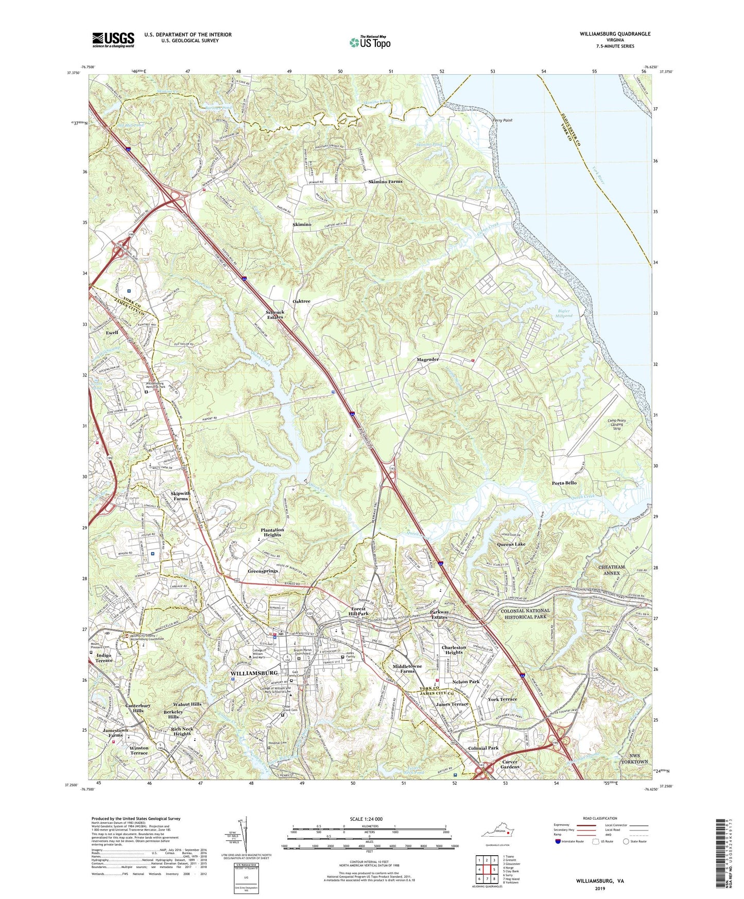
2022 topographic map quadrangle Williamsburg in the state of Virginia. Scale: 1:24000. Based on the newly updated USGS 7.5' US Topo map series, this map is in the following counties: York, Williamsburg (city), James City, Gloucester. The map contains contour data, water features, and other items you are used to seeing on USGS maps, but also has updated roads and other features. This is the next generation of topographic maps. Printed on high-quality waterproof paper with UV fade-resistant inks.
Quads adjacent to this one:
West: Norge
Northwest: Toano
North: Gressitt
Northeast: Gloucester
East: Clay Bank
Southeast: Yorktown
South: Hog Island
Southwest: Surry
This map covers the same area as the classic USGS quad with code o37076c6.
Contains the following named places: Abby Aldrich Rockefeller Folk Art Collection, Adair Gymnasium, Andrews Hall, Baldwin Memorial Garden, Banbury Cross, Barlows Corner, Barlows Pond, Barlows Pond Dam, Barrett Hall, Beaver Dam, Beaverdam Pond, Bell Building, Bell Hospital, Belo Shopping Center, Berkeley Commons Outlet Center, Berkeley High School, Berkeley Hills, Berkeley Middle School, Bigler Mill, Bigler Mill Dam, Bigler Millpond, Blaine Landing, Blow Gymnasium, Blow Memorial Hall, Botetourt Residence Complex, Brafferton, Bridges House, Brown Hall, Bruton Census Designated Place, Bruton Heights School, Bruton High School, Bruton Parish Episcopal Church Cemetery, Bryan Complex, Bryan Hall, Burkes Corner, Busch Commerce Park, Busch Industrial Park, Busch Soccer Field, Busch Tennis Courts, Camm Hall, Camp Peary, Camp Peary Landing Strip, Camp Skimino, Campus Center, Canterbury Hills, Carriage Heights, Carter Creek, Carver Gardens, Cary Stadium, Cedar Grove Cemetery, Cedar Valley Shopping Center, Center for Archaelogical Research, Chandler Hall, Charleston Heights, Chisel Run, City of Williamsburg, College Apartments, College Landing Park, College of William and Mary, College of William and Mary School of Law, College Yard, Colonial Campground, Colonial Park, Colony Square Shopping Center, Commuter Student House, Corner House, Crim Dell, Davis House, Dawson Hall, Decorative Arts Branch Colonial Williamsburg Foundation Library, District 1, Druid Hills, Duncan Pond, Dupont Hall, Earl Gregg Swem Library, Eastern State Hospital, Ewell, Ewell Hall, Ewell Industrial Park, Ewell Station Shopping Center, Farm Fresh Shopping Center, Ferry Point, Folk Art Branch Colonial Williamsburg Foundation Library, Forest Hill Park, Fort Magruder, Fort Magruder Heights, Fraternity Complex, Galt Family Cemetery, Golden Horseshoe Golf Course, Governors Palace, Graduate House, Greensprings, Haring Swamp, Hawtree Landing, Historic Trades Branch Colonial Williamsburg Foundation Library, Hoke House, Holmes House, Horsby House, Hospital Cemetery, Hunt Hall, Indigo Terrace, International Center Business Center, James Blair Hall, James Blair Middle School, James City County Courthouse, James Terrace, James York Mobile Home Park, Jamestown Academy, Jamestown Farms, James-York Plaza Shopping Center, Jefferson Hall, Jones Family Cemetery, Jones Hall, Jones Mill Pond Dam, Jones Millpond, Joseph L Muscarelle Muscarelle Museum of Art, Keck Environmental Field Lab, Kings Creek Commerce Center, Kingsgate Green Shopping Center, Kiwanis Municipal Park, Lake Matoaka Art Studio, Lambert House, Landrum Hall, Lettie Pate Whitehead Evans Graduate Student Housing, Magruder, Magruder Elementary School, Magruder Middle School, Marshall Wythe Hall, Marshall-Wythe Law Library, Marshall-Wythe School of Law, Matoaka Dam, Matoaka Lake, Matthew Whaley Elementary School, McCormack-Nagelsen Tennis Center, McGlothlin-Street Hall, Middletowne Farms, Millington Hall, Monroe Hall, Monticello Post Office, Monticello Shopping Center, Morton Hall, Mount Pleasant Cemetery, National Center for State Courts, National Wildflower Refuge, Nelson Park, New Quarter Industrial Park, Oaktree, Old Dominion Hall, Old Lodges, Old Mill Pond, Old Mill Pond Dam, Old Quaker Estates, Old Stage Manor, Palace Green, Paper Mill Creek, Parkway Estates, Penniman Road Commerce Park, Phi Beta Kappa Memorial Hall, Physical Plants Crafts Shop, Plantation Heights, Porta Bello, Powell Dam, Powell Lake, President's House-College of William and Mary, Prime Outlets at Williamsburg Shopping Center, Prince George House, Providence Hall, Quarterpath Park, Queens Lake, Queens Lake Dam, Queens Lake Middle School, Queenswood, Randolph Student Residence Complex, Recreational Sports Center, Reves Center for International Studies, Rich Neck Heights, Riverside Doctors' Hospital, Schenck Estates, Scotts Pond, Sentara Williamsburg Regional Medical Center, Skimino, Skimino Creek, Skimino Dam, Skimino Farms, Skimino Hills, Skimino Pond, Skipwith Farms, Springfield, Springfield Terrace, Sunken Garden, Taliaferro Hall, The Brafferton, The Capitol, The Hamlet, The Mews, The Sir Christopher Wren Building, Trinkle Hall, Tutters Neck Pond, Tutters Neck Pond Dam, Tyler Hall, Village of Williamsburg, Wabden Pond, Waller Mill Dam, Waller Mill Elementary School, Waller Mill Reservoir, Walnut Hills, Walnut Hills Baptist Church Learning Center, Walsingham Academy Lower School, Walsingham Academy Upper School, Washington Hall, Water Country USA, Whiteman Swamp, William and Mary Hall, William Barton Rogers Hall, Williamsburg, Williamsburg Battlefield, Williamsburg Christian Academy, Williamsburg Community Hospital, Williamsburg Crossing Shopping Center, Williamsburg Historic District, Williamsburg Memorial Park, Williamsburg Municipal Building, Williamsburg Office Park, Williamsburg Post Office, Williamsburg Regional Library, Williamsburg Shopping Center, Williamsburg Terrace Mobile Home Park, Williamsburg Theatre, Winston Terrace, York County Department of Fire and Life Safety Station 3 Bruton, York County Department of Fire and Life Safety Station 5 Skimino, York County New Quarter Park, York Terrace, Zable Stadium, ZIP Code: 23187